
| Trumpington Local History Group Clay Farm Archaeology Open Day: 11 August 2010 |
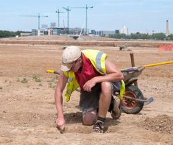
| Over 100 people attended an Open Day at the Clay Farm archaeology site on 11th August 2010. This was organised by Richard Mortimer of Oxford Archaeology East, Project Manager, with help for publicity by Stephen Brown. We are indebted to both of them. Small groups were given tours of the site by team members; one group by invitation was led by Tom Phillips, Project Officer for the excavation, and we are grateful to him for providing most of the information reported here, and for checking this text for any glaring inaccuracies. Report by Howard Slatter. |
| Copyright © Trumpington Local History Group, 2014. Updated 1 July 2014. Email: admin@trumpingtonlocalhistorygroup.org |
| Archaeological investigations on Clay Farm, near Shelford Road and the Addenbrooke's Road, with the hospital in the distance. Photo: Stephen Brown, 19 July 2010. |
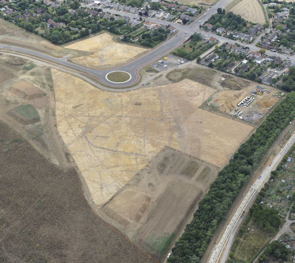
| Aerial view of the archaeological investigations on Clay Farm, to the east of Shelford Road, with the new Addenbrooke's Road and work on the Guided Busway in the old railway cutting, July-August 2010. Looking across the site from north east at bottom to south west at top. Source: Oxford Archaeology East. |
| The archaeology of an area of approximately 6 hectares to the east of Shelford Road is being investigated by a team from Oxford Archaeology East (formerly CAMARC of Cambridgeshire County Council). This is in preparation for the development of the site for housing by Countryside Properties Ltd; the cost of the archaeology is borne by the developers. A further area to the north, nearer Long Road, will be investigated once this first section is complete. The first phase evaluation of the archaeological potential was the digging of trial trenches across the whole of the Clay Farm site in 2005, after some initial geophysics. Based on the findings of that first evaluation, it was decided that the two areas mentioned should be excavated more thoroughly. About 70 cm of the topsoil was removed in early May 2010, and since then the archaeologists have been on site; they expect to complete this phase by the end of September. Once the topsoil was removed, a large number of surface features were revealed. These vary in date from ditches from the middle Bronze Age (1500 to 1200 BC) up to modern field drains and trenches associated with the use of the site for the Royal Show in 1951 and 1961. The aerial photograph shows many of these features quite clearly, as darker lines and patches on the generally lighter coloured gravel subsoil. Those ditches and other features which were identified as medieval or earlier were then excavated, either with sampling trenches or completely. There is a series of roughly parallel middle Bronze Age ditches, which would have served as field boundaries. Most are quite narrow (about a metre across at the topsoil horizon), but two are much bigger, being about two metres wide. Originally these would all have been accompanied by a bank made from the spoil, but that has been lost over time. In section, the darker infilling of the ditch itself is very obvious when compared with the surrounding gravel. The larger ditches are thought to be a 'political statement' by the owner, representing his local status, and would have been a second phase of construction after the smaller ditches were dug. |
| In the north-eastern corner of the site is a series of post holes, a pit and associated burnt sandstones. This could have been a settlement, or more likely a structure for processing crops or treating animal skins, as it is on the lower part of the site and may have been too wet for an actual settlement. The pit would have contained water, and the stones heated in a fire before being placed in the pit to heat the water. The nearby broad curved ditch contains a very dark infill, indicating charcoal and domestic debris; a lot of pottery sherds and three flint arrowheads were found here. The ditch itself seems to form part of a D-shaped enclosure, and is probably from the late Bronze Age/early Iron Age. A Romano-British ditch crosses above this curved older ditch. There are also several large deep Roman pits, probably for water; one was being excavated as we were shown round, and contained the discarded skull of a cow; many animal bones have been found on the site, nearly all those of cattle. The truncated remains of a small early Roman era pottery kiln were visible, complete with a broken kiln bar; originally this would have been covered with a clay shell and pots would have been baked inside. The shell would be broken to access the pots after firing, then the kiln reused a few times before abandoning it. |
| Along the modern northern edge of the site are a series of parallel trenches of much more recent origin. It is possible that these are 19th century coprolite diggings, or are the remains of gravel extraction; further excavation is planned. The western end of the site contains a late Iron Age settlement. The perimeter ditch has been fully excavated, but no domestic rubbish was found, and there is now no trace of the house itself. Alongside the ditch was found a human baby inhumation. |
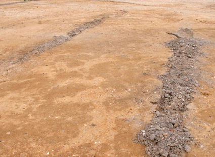
| Series of narrow parallel cultivation beds at about three metre spacing. Photo: Stephen Brown, 11 August 2010. |
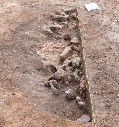
| Truncated remains of a small early Roman period pottery kiln. Photo: Stephen Brown, 11 August 2010. |
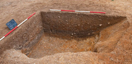
| Part of the large trench of the 'D' shaped enclosure. Photo: Stephen Brown, 11 August 2010. |
| There are two features of interest on the part of the site to the south of the new Addenbrookes Road. Firstly is a series of narrow parallel cultivation beds at about three metre spacings. It is not known what they were used for; possibilities are vines or other fruit, but no evidence has been found. In the southern corner is a large double ditched enclosure. Other than the find of a Neolithic flint blade, the surface proved to be archaeologically sterile. However, at one location within the inner ditch itself were some very abraded late Roman pottery sherds, together with five late Roman bracelets, some large Roman nails and fragments from three different human skulls. It is believed to be some kind of funerary monument, with the remains brought in from elsewhere. |
| Finds on display in the team's store included much domestic pottery from the Bronze and Iron ages and the Roman era; a fragment of Samian ware, mended with a lead staple; a couple of Roman coins; and a piece of a first century AD pillar-moulded glass bowl. |