
| Trumpington Local History Group Background to bird names on Seven Acres |
| Copyright © Trumpington Local History Group, 2016. Updated 2 January 2016. Email: admin@trumpingtonlocalhistorygroup.org |
| Sign at the entrance to the Seven Acres development. Photo: Howard Slatter, November 2015. |
| When the Local History Group and the Residents' Association proposed names as street names in 2010-11, Howard Slatter recommended a set of bird names for the particular species that he knew could be seen on the farmland which was due to turn into the new Clay Farm development. The concern at that time was whether these species would still be seen after the houses were built. We are very pleased that the developer of Seven Acres did adopt the names and we are beginning to see how the bird species are faring. Howard has had a conversation with a resident of one of these roads, in which she started to complain that these were just pretty names dreamed up by the developer; he soon put her right. Kingfisher Gardens is the road off Addenbrooke's Road into the Seven Acres development. This was part of the first phase, with homes constructed in 2012-13 and occupied from late 2012. Lapwing Avenue is the road going east (left) from Kingfisher Gardens, parallel with Addenbrooke's Road. The first homes were constructed from 2012 and work continued to 2014, with the homes occupied from mid 2014. Skylark Road is at the western end of the development, off Kingfisher Gardens. Homes were constructed in 2012-13 and occupied from 2013. Partridge Close is located off Skylark Road, between Kingfisher Gardens and Addenbrooke's Road. Homes were constructed in 2012-13 and occupied from 2013-14. |
| Seven Acres streets. Source: © OpenStreetMap contributors (Howard Slatter). |
| Howard Slatter gave a presentation about the origin of the names 'Kingfisher Gardens', 'Lapwing Avenue', 'Skylark Road' and 'Partridge Close' at the Local History Group meeting on 12 November 2015. These streets are named after birds which were common on the land prior to the construction of Addenbrooke's Road and the Seven Acres housing development. There is a separate page with information about the derivation of street names. |

| We are fortunate in having a number of aerial photographs of the area, including one from 2002, looking south, while the land was still farmed, and 2015, showing the Seven Acres area bottom left and the large pond in the green space that will soon be the Clay Farm park. This balance between housing, green spaces and a large pond has been an important factor for the bird species. |
| Kingfishers can be seen every winter on Hobson’s Brook, and occasionally in summer. Howard Slatter has been recording the birds seen in this area since 1988 and in August 2001 he saw a family party of 5 birds on the brook, which suggests that they may have bred here. |


| Kingfisher Gardens. Photo: Andrew Roberts, 20 November 2015. |
| The native grey partridge, as opposed to the introduced French or red-legged partridge, is one of the species on the Royal Society for the Protection of Birds (RSPB) 'red list' of birds, having undergone serious declines in its population during the last 30 years. In that time, Howard certainly saw numbers on the farmland go down considerably, but since coming out of agricultural production, their numbers have increased to levels well above those of 25 years ago. The Clay Farm park is now one of the best places in the county to see these birds. |


| Partridge Close. Photo: Andrew Roberts, 20 November 2015. |
| The skylark tells a similar story. The park has a very healthy breeding population, despite another tale of national decline, and being red-listed by the RSPB. |


| Street sign on Skylark Road. Photo: Andrew Roberts, 20 November 2015. |
| The northern end of Skylark Road. Photo: Andrew Roberts, 20 November 2015. |
| The skylark tells a similar story. The park has a very healthy breeding population, despite another tale of national decline, and being red-listed by the RSPB. |
| And finally, the lapwing. A rather different story here, again amidst a picture of national decline. When this area was farmed, there were large winter flocks of lapwing on and over the fields. This graph shows the number Howard has recorded every month since 1988. In the 1990s, there were winter flock sizes of up to 4000 birds, gradually declining until in the 2010-11 winter Howard saw hardly any. But from summer 2011 onwards, once farming had stopped and the pond was excavated, lapwings started breeding here for the first time in Howard's experience. There have now been up to 5 pairs nesting round the pond every summer. Howard suspects that once the park is fully open and the amount of human pressure increases accordingly, this number will shrink, but one or two pairs should hold on. |
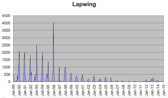
| Lapwing occurrence in Trumpington, 1988 to 2015. Source: Howard Slatter. |


| Lapwing Avenue and Raeburn House. Photo: Andrew Roberts, 11 April 2015. |
| Street signs at the junction of Lapwing Avenue and Kingfisher Gardens. Photo: Andrew Roberts, 20 November 2015. |
| So all the street name birds are still here, and can, with a bit of luck, be seen from the housing development. |

| Aerial photograph of Clay Farm from the south east, with Seven Acres lower left. Countryside/Tamdown, 9 September 2015. |

| Aerial photograph of Clay Farm from the north, before the development of Addenbrooke's Road and housing, with the main railway line to the left, Shelford Road and the camp site upper right. Source: Howard Slatter. |
