Cambridge-Barkway turnpike road (Trumpington Road/Trumpington High Street):
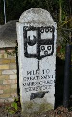
The first milestone erected by Trinity Hall on the Cambridge-Barkway turnpike road, Trumpington Road/Brooklands Avenue. Andrew Roberts, Mar 2017.
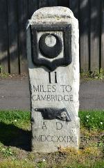
The second Trinity Hall milestone on Trumpington High Street near Wingate Way. Andrew Roberts, Apr 2017.
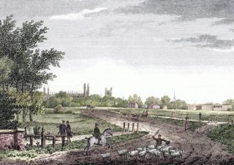
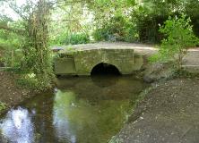
‘Cambridge from the London road’, looking from the Stone Bridge and the first milestone to Coe Fen and the road into Cambridge, Cantabrigia Depicta . R.B. Harraden, 1809.
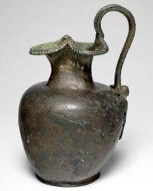
Bronze jug dated to 30-70 AD, discovered at Dam Hill (between Latham Road and Chaucer Road). The Fitzwilliam Museum, Cambridge / Reproduced with the kind permission of the Master and Fellows of Trinity College, Cambridge
Welcome to The Changing Face of Trumpington . This is one of a series of pages showing how Trumpington has changed over time, with this page about the area to the north of the village centre. The information is on display in the Clay Farm Library at The Clay Farm Centre. See the Introduction for a link to other pages.
Evelyn Nursing Home/Nuffield Hospital, Trumpington Road:
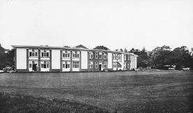
Evelyn Nursing Home, founded in the early 1920s. Percy Robinson, 1920s.
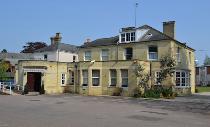
The Evelyn Nursing Home became the Nuffield Health Hospital in 2003. Andrew Roberts, Apr 2011.
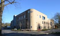
New building constructed for the Nuffield Hospital, 2014-15. Andrew Roberts, Jan 2018.

Trumpington Road/Long Road:
G. Willers, nurseryman premises, on the corner of Trumpington Road and Latham Road, Cambridgeshire Collection. Cambridge Central Library, c. 1900.
House at the corner of Trumpington Road and Latham Road. Andrew Roberts, Jan 2018.
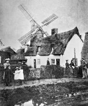
Windmill near the junction of Long Road (formerly Mill Road) and Trumpington Road, 1873. There is a path and cottages in the foreground, with a number of men, women and children, and the mill in the background. Cambridgeshire Collection, Cambridge Central Library.
Trumpington Road/Long Road:
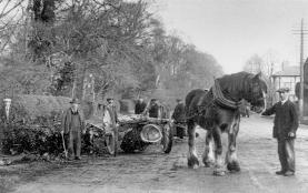
Clearing fallen trees on Trumpington Road, a timber drug, c. 1930. Antony Pemberton (Dr Stephen Brown).
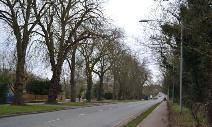
Looking north east along Long Road from near Clay Farm house, as contractors start to remove trees in preparation for the construction of the Clay Farm spine road (Lime Avenue). Andrew Roberts, Jan 2011.
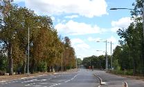
Nearing the completion of work to widen Long Road at the new junction with Lime Avenue. Andrew Roberts, Sep 2012.
North of Long Road:
Looking towards the footbridge over Hobson’s Brook, between Long Road and Porson Road, with the original line of the Vicar’s Brook on the right. Howard Slatter, Oct 2010.
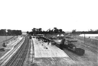
The Royal Show was held north of Long Road in 1922, with a railway station between the main line and the Bedford line. The Royal Show Station in use by freight and passengers, The Railway Magazine , 1922. Edmund Brookes.
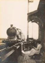
Sarah Fairweather sitting outside the Long Road railway gatehouse, at the level crossing on the main line (before the bridge was built), 1920s. Jane Fairweather.

St Faith’s Preparatory School, Trumpington Road:
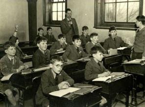
St Faith’s classroom, c. 1950s. Howard Slatter.
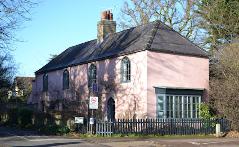
St Faith’s School House and new entrance gates. Andrew Roberts, Apr 2011.