Trumpington High Street:
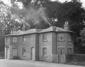
The Toll House and Weighbridge House, High Street, in the 1920s. Percy Robinson collection.
The Tour de France peloton passing the Tollhouse on Trumpington High Street. Bridget Partridge, Jul 2014.
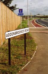
Addenbrooke’s Road street sign at the Shelford Road junction, the day of the opening of the new road. Photo: Andrew Roberts, Oct 2010.
Welcome to The Changing Face of Trumpington . This is one of a series of pages showing how Trumpington has changed over time, with this page about the area to the south of the village centre including Glebe Farm. The information is on display in the Clay Farm Library at The Clay Farm Centre. See the Introduction for a link to other pages.

Shelford Road/Hauxton Road junction:
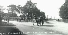
‘Shelford and Royston Roads’, Trumpington, Ted Mott, 1920s. Cambridgeshire Collection. Cambridge Central Library.
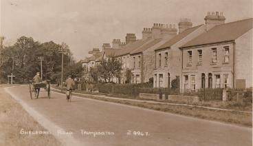
Shelford Road from the junction with the High Street and Hauxton Road, c. 1914. (A postcard sent to Kitty Willers in 1914). Cambridgeshire Collection. Cambridge Central Library.
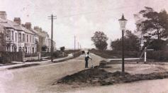
Shelford Road, from the junction with the High Street and Hauxton Road, 1930, with houses on the north east side of the road up to and beyond the railway bridge, an AA box at the junction, a line of telegraph poles but no street lights. Cambridgeshire Collection, Cambridge Central Library.
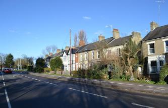
Shelford Road:
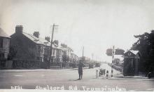
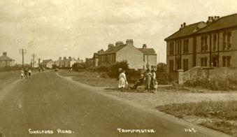
Looking from the west side of Shelford Road to the earliest houses, numbers 3-17, towards the junction with Trumpington High Street, 1920s. There is a horse and trap and cyclist in the road, a finger sign post at the junction, a grass and gravel roadside verge and telegraph poles and wires along the verge. Cambridgeshire Collection, Cambridge Central Library.
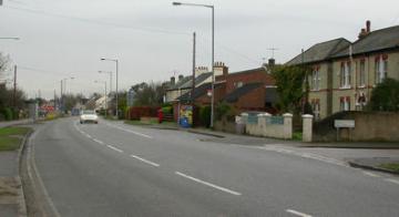
Shelford Road near the High Street junction. Andrew Roberts, Jan 2018.
Shelford Road:
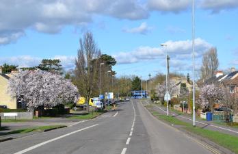
Spring blossom on Shelford Road, with the width resulting from its history as a former turnpike road. Andrew Roberts, Mar 2017.
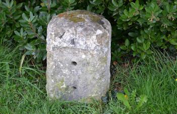
The Stump Cross Turnpike milestone near 174 Shelford Road. Andrew Roberts, Apr 2017.
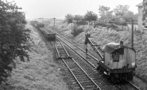
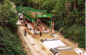
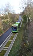
Railway cutting to the east of Shelford Road bridge:
The removal of the railway track from the cutting to the east of the bridge. Margaret Marrs, 1969 (Dr Stephen Brown).
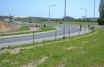
Laying the track for the Busway to the east of the bridge. Andrew Roberts, Sep 2010.
The Busway in operation, from Shelford Road bridge. Andrew Roberts, Dec 2011.
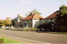
Shelford Road/Bishop’s Road junction:
Shelford Road in c. 1927, at the junction with Bishop’s Road (with a name plate at the start of Bishop’s Road), showing 80-82 Shelford Road and other houses, with a group of people possibly waiting for a bus. The group probably include Mrs Amelia Pamplin and her disabled son William Pamplin (in wheelchair), who lived at 80 Shelford Road (the house to the right). The road has a good surface but there is no pavement. There is a line of telegraph posts on the east side of the road. John Galley (Dr Stephen Brown).
Shelford Road at the junction with Bishop’s Road, showing 80-82 Shelford Road and other houses. Howard Slatter, Nov 2008.
Glebe Farm farmland:
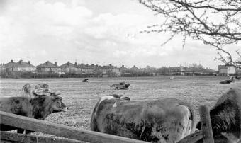
Looking across the farm to Bishop’s Road. Maurice Rayner, 1964 (Dr Stephen Brown).
Looking from Bishop’s Road towards the farmhouse. Dr Stephen Brown, 2002.
Glebe Farm, from farmland to housing:
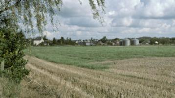
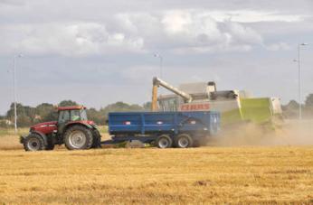
Harvesting on Glebe Farm, looking towards Bishop’s Road, with Addenbrooke’s Road in the background. Dr Stephen Brown, Aug 2008.
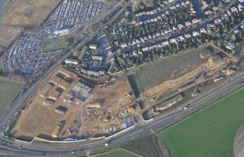
Glebe Farm development area, with Addenbrooke’s Road below and Hauxton Road to left. Tamdown/Countryside Properties, Dec 2011.
Glebe Farm and Hauxton Road:
Shepherd, sheep dog and sheep in snow on the Cambridge to London road (Hauxton Road), c. 1890. Cambridgeshire Collection. Cambridge Central Library.
Advertising signs for the Novo development (Glebe Farm), Hauxton Road. Andrew Roberts, Mar 2012.
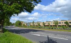
Newly completed homes on Beech Drive from Hauxton Road, Novo development. Andrew Roberts, May 2014.
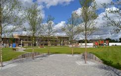
Glebe Farm central play area:
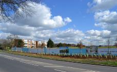
Looking across the site of the central play area towards Bishop’s Road, from the roof of the Glebe Farm show home. Elizabeth Rolph, Apr 2012.
Play area under construction. Andrew Roberts, Jul 2012.
Play area and Tebbit Street, Novo development. Andrew Roberts, Nov 2012.
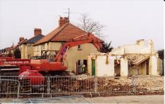
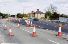
Addenbrooke’s Road junction, east side of Shelford Road:
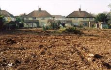
Preliminary work to clear the grounds of 109-13 Shelford Road. Andrew Roberts, Nov 2007.
Demolition work on the east side of Shelford Road. Andrew Roberts, Dec 2007.
Work on the realignment of Shelford Road at the Addenbrooke’s Road junction. Andrew Roberts, May 2009.
Addenbrooke’s Road roundabout, east of Shelford Road:
Clearance work at the rear of 107-113 Shelford Road, from the Showground site. Andrew Roberts, Nov 2007.
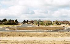
Surfacing the new road and roundabout to the east of Shelford Road. Andrew Roberts, Apr 2008.
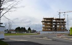
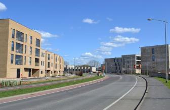
Building apartments at the Addenbrooke’s Road roundabout, Abode development, Clay Farm. Andrew Roberts, Mar 2013.
From Showground fields to Addenbrooke’s Road:
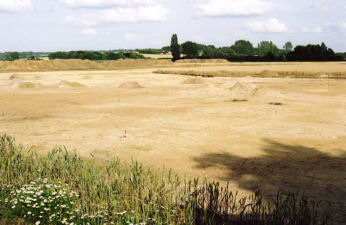
Clearing topsoil for archaeology excavation on the line of Addenbrooke’s Road, Showground site to the north east of Shelford Road, looking across the site to south east. Andrew Roberts, Jul 2007.
Progress with the construction of Addenbrooke’s Road between Shelford Road and the railway, with the railway bridge and Addenbrooke’s in the distance. Andrew Roberts, Sep 2008.
Looking along Addenbrooke’s Road toward Hobson’s Brook and the railway bridge. Andrew Roberts, Apr 2011.
Homes on Ellis Road, Partridge Close and Kingfisher Gardens, Paragon and Seven Acres developments. Andrew Roberts, Apr 2015.