Village origins, excavations at Trumpington Meadows and Anstey Hall Farm gave evidence of a Saxon settlement near the current church:
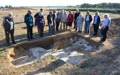
Looking at a Late Saxon/Early Medieval sunken structure, Trumpington Meadows archaeological site. Andrew Roberts, May 2011.
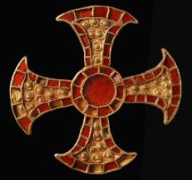
Gold and garnet ‘Trumpington cross’ dated to c. 650 AD, found in a bed burial. © Cambridge Archaeological Unit.
Piper Road being built across the archaeological site. Andrew Roberts, Dec 2014.
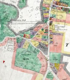
Trumpington village centre, Land Value map for Trumpington, 1910-11 , Cambridgeshire Archives, file 470/047, sheet XLVII.10.
Welcome to The Changing Face of Trumpington . This is one of a series of pages showing how Trumpington has changed over time, with this page focusing on the village centre. The information is on display in the Clay Farm Library at The Clay Farm Centre. See the Introduction for a link to other pages.
Trumpington Church and Grantchester Road:
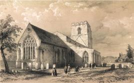
Trumpington Church from the North East, Cambridge Camden Society, 1845. Cambridgeshire Collection. Cambridge Central Library.
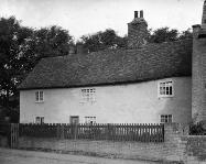
18 Grantchester Road, marked with the date 1654, in the 1920s. Percy Robinson collection.
18 Grantchester Road and nearby houses from the church tower. Andrew Roberts, Apr 2012.
Anstey Hall Farm:
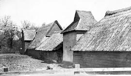
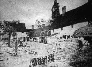
Anstey Hall Farm barns and dovecote, c. 1900s. Percy Robinson collection.
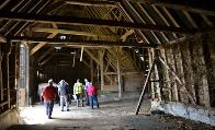
Interior of the main barn, before renovation. Andrew Roberts, May 2015.
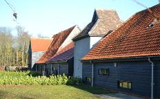
New homes after the renovation of the farm buildings. Andrew Roberts, Dec 2017.
Cross Hill, junction of High Street and Church Lane:
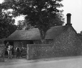
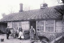
The blacksmith’s workshop at the junction of the High Street and Church Lane, c. 1900. Percy Robinson collection.
Blacksmith’s workshop at the junction of the High Street and Church Lane, c. 1900. Cambridgeshire Collection, Cambridge Central Library.
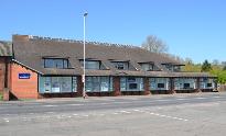
Now Bidwells estate agent Stonecross offices opposite Village Hall. Andrew Roberts, Apr 2017.
High Street:
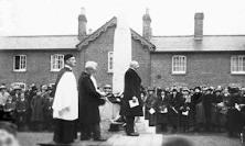
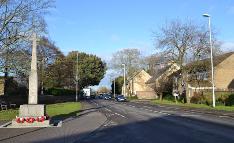
The unveiling of the War Memorial, 11 December 1921. Percy Robinson collection.
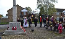
Rev. Andy Chrich and other participants at Trumpington War Memorial, Remembrance Sunday. Andrew Roberts, Nov 2014.
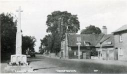
Looking south along the High Street towards Beverley Way, September 1973. The War Memorial is in the foreground, with 71 High Street across the road (soon to be demolished), Beveley Way, the Village Hall and the Tally Ho. Cambridge Antiquarian Society. Cambridgeshire Collection, Cambridge Central Library.
High Street:
High Street with the War Memorial and Red Lion, 1920s. Source: Cambridgeshire Collection, Cambridge Central Library.
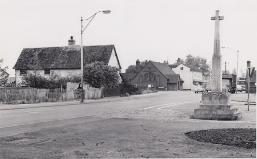
High Street/Church Lane junction, looking north, now with houses. Andrew Roberts, Dec 2017.
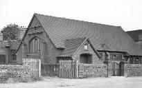
Village Hall, with the entrance to Manor Farm to the left, 1920s. Percy Robinson collection.

High Street/Maris Lane:
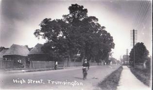
Looking north along the High Street from the east side of the road, opposite Maris Lane, with Church Farm stack yard and trees on the left, 1920s. The woodyard is hidden in the trees, with Newell’s shop beyond. The entrance to the recreation ground is on the right. Cambridgeshire Collection, Cambridge Central Library.
The Mayor of Cambridge and local children from Fawcett School, at the unveiling of the new village sign, in front of Bidwells (site of the stack yard). Dr Stephen Brown, Jun 2010.
E.J. Smith & Sons, Carpenters, Wheelwrights and Undertakers, 1920s. Percy Robinson collection.
High Street:
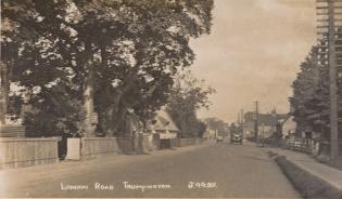
Looking north along the High Street, with the gate into the wood yard and lock up on the left and the thatched cottage beyond, early 1920s. The recreation ground is to the right, with P.E. Noble’s shop (‘The Hut’) on the right further along the road. Cambridgeshire Collection, Cambridge Central Library.
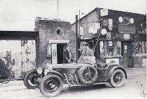
H.J. Newell and Sons shop and garage and the village lock up, 1932. In the foreground, Frank Whittle is standing beside his car being served petrol by Harry Newell in front of the village lock up, with the shop to the right. Cambridgeshire Collection, Cambridge Central Library.
Noel Young Wines, Gregory’s Pharmacy and Opticians, High Street. Andrew Roberts, Jan 2018.
Whitelocks/Whitlocks:
Cottages and yard, thought to be Whitelock’s in the 1880s. Percy Robinson collection.
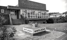
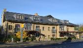
Rebuilt in 1960s, now named Whitlocks. Jo Elliot (Dr Stephen Brown), c. 2000.
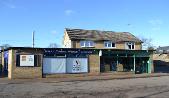
Rebuilt in 2004. Andrew Roberts, Nov 2012.
Coach & Horses/Wok ‘n’ Grill:
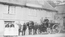
The Coach & Horses pub, c. 1900. There is a horse-drawn cart from the Sawston Aerated Water Company in front of the pub and three women and two men in the foreground. Cambridgeshire Collection, Cambridge Central Library.
The Coach & Horses pub, 1920s. Percy Robinson collection.
The Coach & Horses/Wok ‘n’ Grill. Andrew Roberts, Apr 2017.
The Green Man:
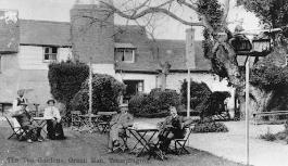
The Green Man Tea Gardens, 1900s. Looking across the tea gardens: at ground level, there are four customers at two tables, with a waiter in the background; there are two additional women in a tree house to the left. The pub is in the background, including its Medieval chimney. Cambridgeshire Collection, Cambridge Central Library.
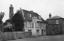
The Green Man pub, 1920s. Percy Robinson collection.
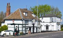
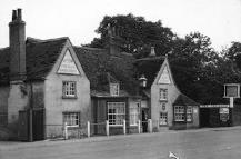
The Green Man pub, on the east side of the High Street. Andrew Roberts, Apr 2017.
The Unicorn pub/Lord Byron Inn:
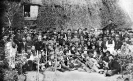
A group of nearly 100 men gathered in front of the thatched Unicorn public house, with the Trumpington Brass Band in the foreground and the Amicable Brotherly Friendly Society in the background, and three figures looking on from a window. The photograph has been dated to probably the early 1880s. Percy Robinson collection.
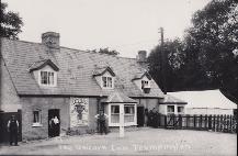
The Unicorn Inn, early 1920s, with 5 figures in front of the public house, a marquee in the grounds to the right and an advertisement for Dale’s Prize Beers. There is a large lantern with the name ‘The Unicorn’ above the door. The licensee sign over the door names Thomas Pawsey (Thomas and Margaret Elizabeth Pawsey are known to be at The Unicorn in 1920-23). Cambridgeshire Collection, Cambridge Central Library.
Renamed The Lord Byron pub, May 2012. Andrew Roberts, Feb 2015.
The Tally Ho pub/Hudson’s Ale House:
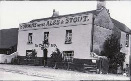
The Tally Ho public house, 1920s. The frontage of the pub has ‘The Tally Ho.’ over the door and ‘Hudson’s Noted Ales and Stout.’ in larger text under the roofline. There is a lantern with the name ‘Tally Ho’ above the door. The Village Hall is just visible to the left. Cambridgeshire Collection, Cambridge Central Library.
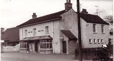
The Tally Ho pub. Peter Dawson, 1970s.
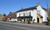
Renamed Hudson’s Ale House, October 2015. Andrew Roberts, Apr 2017.