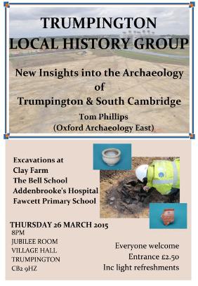
There were over 60 participants at the Local History Group meeting in the Village Hall on 26 March 2015, when Tom Phillips, Project Officer, Oxford Archaeology East, gave an update on the archaeology of Trumpington and the Southern Fringe of Cambridge. Report by Andrew Roberts.
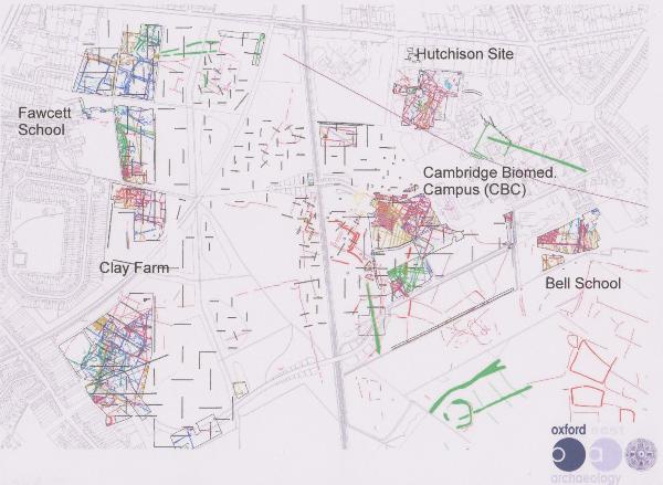
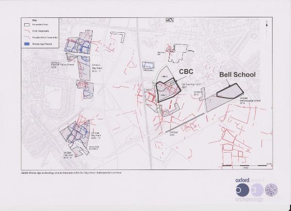
Tom Phillips concentrated on excavations by Oxford Archaeology East (OAE) at Clay Farm (2010-11), Fawcett Primary School (2014), Cambridge Biomedical Campus (CBC) (Papworth Hospital) (2014) and the Bell School (2014). Tom was project manager of the large scale excavation at Clay Farm and the more recent excavations across the Southern Fringe. In addition to the work by OAE, other sites have been excavated by the Cambridge Archaeological Unit (CAU), including work on the line of Addenbrooke’s Road and across the CBC development at the Hutchinson, Laboratory of Molecular Biology (MRC-LMB) and AstraZeneca sites.
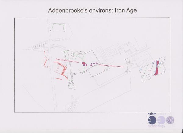
Tom focused on the Prehistoric archaeology of the ‘Hobson’s Brook valley’, with intensive archaeological evidence in the land both sides of the valley and a quiet area in the valley itself. He kindly provided a copy of his illustrations, some of which have been incorporated in this report.
This was the latest in a series of site visits and talks about the significant discoveries that have resulted from the housing, infrastructure and biomedical developments in and around Trumpington See the Subjects page for a checklist of site visits and other archaeology talks.
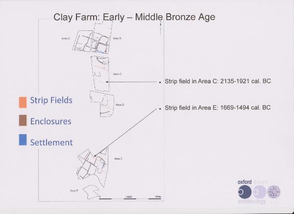
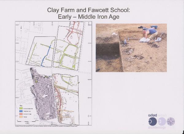
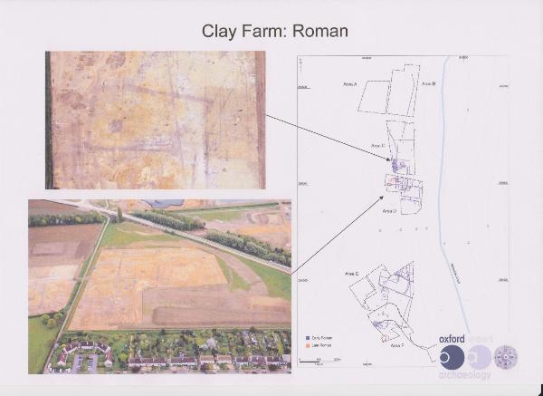
During the OAE excavations, Clay Farm was divided into six areas:
A, south of Long Road, east of Wingate Way, at the northern end of the site (now the Halo development area);
B, south of Long Road, between Area A and the spine road, at the northern end of the site (now the Halo and Aura development areas);
C, south of the tree belt, east of Fawcett School and the Cambridge Professional Development Centre (CPDC) to the spine road, west of the community college site;
D, east of Foster Road (now including the Virido development area and the local square);
E, east of Shelford Road (now the Abode and Paragon developments);
F, also east of Shelford Road, south of the Addenbrooke’s Road roundabout (now the Abode and Seven Acres developments).
Bronze Age evidence
Tom starting with the Bronze Age evidence from Clay Farm and Fawcett School, on the west side of the valley.
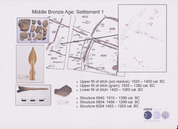
Tom said that in the Middle Bronze Age, from c. 1500 BC, the Clay Farm landscape was divided into large fields for the first time. There was a network of regular linear strip fields, with their boundary ditches running across the contours. The earliest parts of the network have been dated to before 1500 BC, which was unusually early compared with other sites. The researchers had carried out an intensive radio-carbon dating programme and had been able to obtain 25 radio-carbon dates making this one of the best dated sites in the country. The early network was followed by more complex field systems which were maintained and developed from c. 1500 BC to c. 1250 BC. There was good preservation of organic material, including elderberry seeds near the bottom of ditches, suggesting nearby elder hedges, and smaller quantities of blackthorn and hawthorn.
There were two settlement areas in the north and south parts of the site (in Areas B and E), which Tom suggested were possibly two communities. In Area B, there was an exceptional quantity of midden material, including pottery (some of fine ware), bone, flint, metalwork, and environmental evidence like charred grain. These may have been rubbish middens near the northern settlement, with material eroding into the boundary ditch.
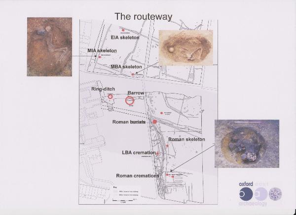
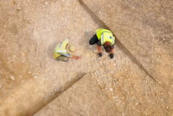
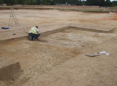
There was further evidence from the recent excavation at Fawcett School, immediately south of Area A and west of Area C in Clay Farm. (The development site is for the extension to the school, to the rear of the original buildings.) This included a Bronze Age barrow and a cremation cemetery with 37 burials. As the barrow was on the edge of the development site, only part of it was excavated. Its first phase was dated to the Early Bronze Age. The cremations were in a series of pits around the perimeter of the barrow, which had been added over an extended period.
The barrow was in a good location overlooking a dip and the valley and only 100 m from the northern settlement. Its dating fitted well with that of the settlement and it seemed likely this area was used for burials from the settlement.
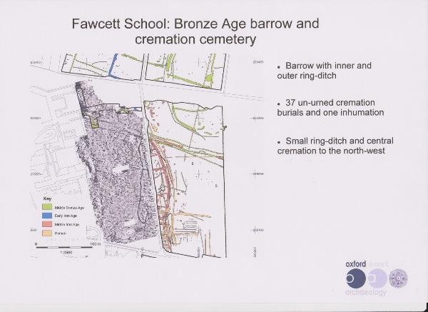

There was a small ring ditch 30 m to the north west of the barrow, with a central burial. This was similar to examples on sites in northeast Essex and Suffolk which were positioned close to earlier burial sites. This suggests an exchange of ideas from the coastal area.
There was also evidence of a routeway which was on a similar alignment to the boundary ditches in nearby Clay Farm. The alignment can be traced for 260 m from the Fawcett site to the east, with more substantial ditches in the dryer areas at the western end. The route is thought to be Middle Bronze Age. Tom said it can be thought of as a route across the landscape rather than a specific track. It is possible the alignment had been in use from the Neolithic and gradually became formalised in the Bronze Age, acting as a statement of ownership. Tom said that there is evidence that the alignment became an ongoing focus for burials, including Early and Middle Iron Age and high status Roman cremations.
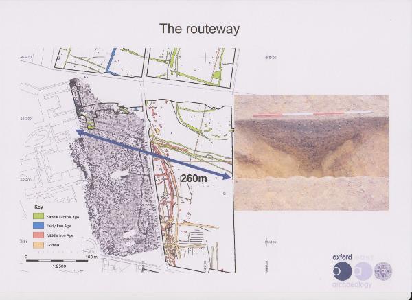
The alignment probably became a road in the later period. The route may have extended to the west, past a possible Bronze Age? barrow (near the High Street/Alpha Terrace junction) and to a river crossing to Grantchester. This alignment has been discussed in an article by Walker in 1911 and in Cyril Fox’s book The Archaeology of the Cambridge Region in 1923. Tom added that the north-south route followed by Trumpington Road was also possibly Roman but may be earlier.

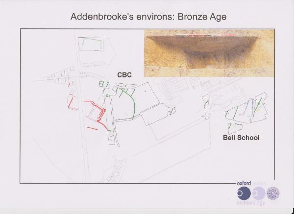
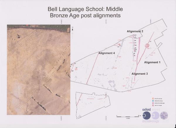
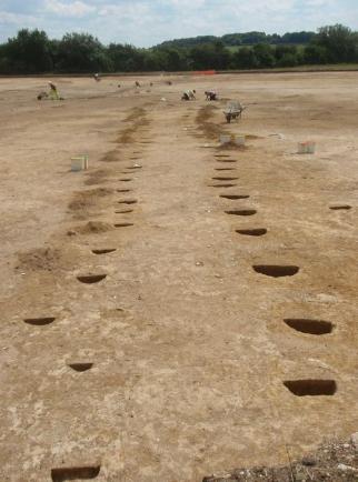
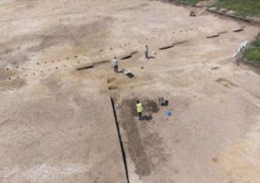
On the east side of the valley, Tom described a major area of Bronze Age settlement. This included a triple ditched enclosure, now cut by the railway line and also identified on the Papworth site. The main feature on the Bell School site was a remarkable pattern of Middle Bronze Age post holes. There were four alignments in the excavated area, running broadly NNE to SSW, each with up to three closely spaced post holes, with a total of around 400 post holes. There was another example of this type of activity at Barleycroft Farm, Bluntisham, where there were 950 post holes in 9 distinct rows, interpreted there as a ceremonial feature. In the Bell School case, the post holes may be another form of boundary or also have a ceremonial function perhaps leading towards the Gog Magog hills. They would have required a large-scale effort.
Iron Age evidence
Turning back to the west side of the valley, Tom noted that the extensive Early – Middle Iron Age evidence from Clay Farm had been covered in previous talks (see March 2012).
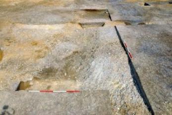
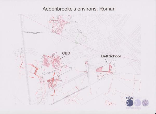
The evidence from the Addenbrooke’s side of the valley was more difficult to analyse. It included areas of stone surfaces, patchy at the Papworth site and more extensive at the Bell School site. The Papworth evidence was difficult to date, with few sherds, but the stratigraphic relationships suggested it was Iron Age. There was better dating evidence at the Bell School site, suggesting the features were Early Iron Age, c. 800-700 BC. A metalled surface had survived in hollows in well draining gravels where there was no practical reason for this type of work. This level of investment was unexpected in the Iron Age and again may have had a ceremonial function.
The alignment at the Papworth site seems similar to the routeway at Fawcett School/Clay Farm. The CAU excavations to the north of the Papworth site also identified this alignment and suggested it was a Roman route. There is also evidence of a north-south route in this complex area.
Roman evidence
By the Roman period, the local area had a substantial scale of activity.
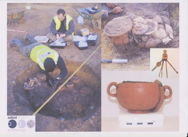
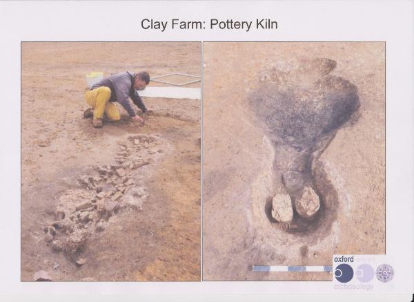
Across Clay Farm, there was evidence of Early Roman settlements. The excavation discovered two high status burials surrounded by enclosures. One cremation burial (east of CPDC) had the remains in a leather covered wooden casket, with a toiletry set (which Tom said still jangles) and stamped pottery dated to c. 43 AD. There was also evidence of craft activity including pottery kilns.
To the east, the recently excavated Papworth Hospital and Bell School areas seemed to be more focused on agriculture in the Early Roman period, with extensive field systems. There were further linear features, which may have been cultivation beds, possibly for asparagus or vines. At this time, there seemed to have been an economic opportunity to produce cash crops for export. This area may have been too wet for settlement, which seemed to have been a short distance to the north (identified during the excavation of the Hutchison site). There are similar examples of cultivation beds on Clay Farm and the North West Cambridge site.

Long-term continuity
Tom stressed that there seemed to have been long-term continuity in land use across the area for over 3000 years. For example, at the CBC sites, a major Bronze Age ditch was overlain by a Roman ditch and the Post-Medieval field system seemed to follow a similar pattern. It was only after the enclosure process in the 19th century that a different field system was introduced.
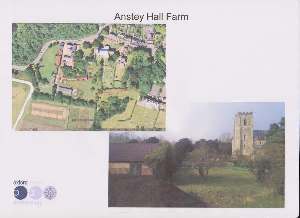
Anstey Hall Farm
Tom ended with a brief reference to current work at Anstey Hall Farm (2015), where OAE had just started to investigate the area adjacent to the Saxon site excavated by CAU in 2011. They hoped to identify boundaries and pits from the 8th-11th centuries AD, Middle-Late Saxon, in an area that was hopefully part of the early layout of the village.
Conclusion
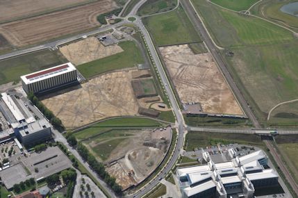
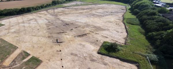
Tom closed his talk with an aerial photograph of the Cambridge Biomedical Campus area, with the Papworth Hospital site to the left and the AstraZeneca site and railway below and to the right. This clearly showed the triple ditched enclosure in the central AstraZeneca area, part of a remarkably rich landscape. The photograph demonstrated the impressive scale of recent excavations.
Questions
1. Comment on the Middle Bronze Age ditches and fields.
Tom: the large scale ditches may have been 3-4 m wide and 1 m deep, probably with hedges and fences. The size seems monumental if it were just for the control of animals and may also have been a political statement. The enclosures were not large enough to hold large numbers of animals for long periods.
2. You presumably have limited time to do the archaeological work during the building projects?
Tom: the excavations are well planned, we know how much time is available and work to this after an earlier evaluation.
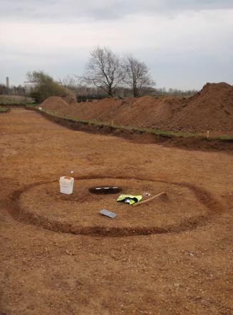
3. Why did you only excavate half of the Fawcett School barrow?
The rest of the area will remain in use as the school playing field, so is safe from development. The idea is to leave evidence in the ground unless it is threatened. We would avoid excavating a barrow with potential burials unless this was necessary.
4. What was the population of the area?
The use of the landscape developed over 1000s of years. There seems to have been an extended family group every 1/2 km or so, a fairly dense population. This was very good farmland at the right contours, with good supplies of water and good drainage.
5. What will happen to the excavated bodies and were there auroch bones?
The bones from bodies have been analysed to check their sex and age but DNA analysis is too expensive and it is difficult to analyse cremations. The ages of the individuals in the Fawcett School barrow range from babies up to 30-40 year old adults.
Tom was not aware of any auroch bones being excavated.
6. How was the metalled road produced by a small population.
The work would have required a large scale effort but may have been done over 100s of years. The community would have had to process the local pebbles.
Howard Slatter closed the meeting with thanks to Tom Phillips and commented on the irony that the latest wave of incomers into the Trumpington area were revealing the past of the area.