Howard Slatter
At the meeting of the Local History Group on 21 November 2013, Howard Slatter discussed sources of information about the history of Trumpington from the 19th and 20th centuries. See also other sources of evidence.
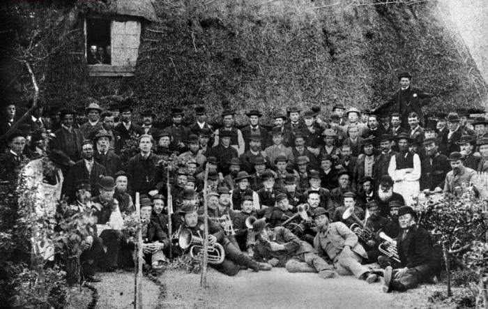
This a picture of the men of Trumpington, taken some time in the 1880s, from Percy Robinson’s slides. A fine body of men, but who were they, individually? I cannot answer that question, but there are ways of finding out something of the lives of the ordinary people of the village.
There is quite a variety of different sources for researching the people of Trumpington through the 19th and first half of 20th century, including:
Parish Registers
Newspapers
Censuses
Electoral Registers
Street Directories
Parish Magazines
Local Societies
The Trumpington Parish Registers have been transcribed up to 1950 by Margaret Marrs and others, and can be supplemented with other information about births, marriages and deaths from online databases, and also by information recorded on memorial stones in the church and churchyard.
To read local old newspapers, one previously had to visit the Cambridgeshire Collection and scour the copies there. Now many of those are available online, with a sophisticated search facility. Searching for Trumpington turns up many references to our village, plus a lot of Trumpington Streets and Trumpington Road in Forest Gate, east London. An example illustrates the kind of thing we can pick up. The 1841 census shows two ladies, Joanna and Sarah Crane, running a “Ladies Seminary” in Trumpington, but it is impossible to work out where that was. And here, in a cutting from the Cambridge Independent Press of 1843, is the answer. Two houses for sale by auction at the Green Man. One, “a modern and substantially built brick and slate dwelling house, desirably situate opposite the church, as now occupied by Miss Crane, as a ladies’ seminary” and the adjoining house, both “situate in the most pleasant part of the village, having good views in front and behind”. The rest of the description makes it clear that it is this pair of houses being described.

Although that cutting comes from a local paper, it is interesting that quite a lot of information comes from much further away – for instance the only mention I have seen of a terrible storm in 1763 that killed the wife and daughter of Elias Bland was in the Bath Chronicle and Weekly Gazette.
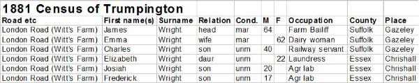
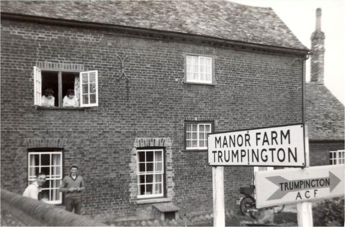
There are plenty of other references to census records, and here is just one example. When the news of the recent street naming award appeared in the Cambridge News , we received an email from someone who wanted to propose another name for future consideration. The name was Mr Samuel Witt, who had never lived in the parish, but had leased a farm from the Pembertons somewhere in Trumpington in the late 1800s. He and his siblings are commemorated in the parish church, but not buried there. Our correspondent did not know which farm his distant cousin had leased, only that it had been managed by a man called James Wright. The 1881 census shows James Wright, a Farm Bailiff, and his family living at Witt’s Farm, in London Road, next door to the Tally Ho.
By comparing this with other census records from earlier and later, we could be quite certain that the farm in question was actually what we think of as Manor Farm, now demolished and built over by Beverley Way and the nearby houses.
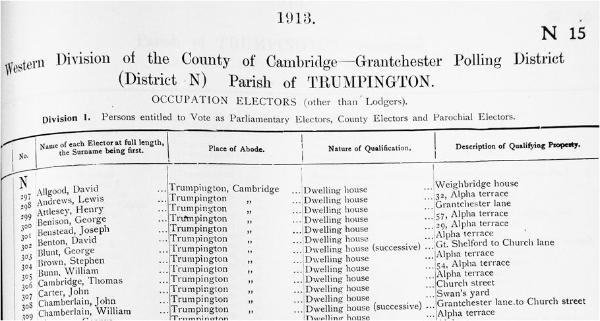
The latest census that is open to public inspection is that of 1911. After that we have to rely on other sources to find out who lived where in Trumpington. Electoral registers are a good way of finding out quite a lot, though they are very much the poor relations of the censuses, as they just give names and addresses, and only names of those entitled to vote. In 1913, the earliest register in the Cambridgeshire Collection after 1911 since the third Reform Act of 1884, the entitlement was only men aged 21 and upwards who owned land valued at £10 or paid an annual rent of £10. But this must have included nearly all the adult males in Trumpington.
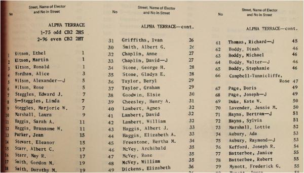
Here we have a page from the 1969 register. By now, of course, all men and women aged 18 and over have the vote. By tracking families through, one can see children achieving their majority and deduce something of the family structure.
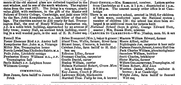
Then there are street directories. This is from the Post Office Directory of 1879, and lists some of the residents, such as the farmers, innkeepers, shopkeepers and craftsmen, but none of the labourers who formed the bulk of the village population. At this stage, Trumpington was just a village in the countryside, and not worthy of a fuller entry.
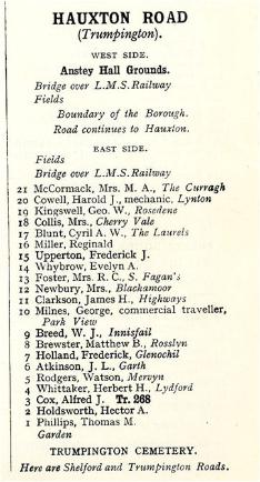
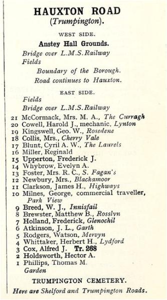
In 1934, of course, Trumpington became fully part of Cambridge, and from then onwards was included in the Cambridge directories published by Spalding’s and later Kelly’s. We can now see a complete list of the heads of household, with in some cases their occupations. Here’s Hauxton Road in 1937 – interestingly, we know from the electoral register that Frank Whittle, inventor of the jet engine, lived at no. 12, Blackamoor, with his wife, but it is his landlady, Mrs Newbury, who is listed here.
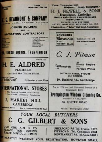
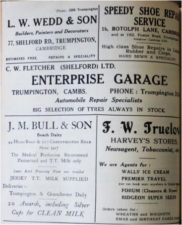
The Parish Magazines are another vital source of information. Arthur Brookes and Ken Fletcher have both drawn on them extensively for information about the men of Trumpington who fought in World War 1. And Shirley Brown has used a lot of the articles written there in compiling her various books about the village. And then there are the advertisements. We can see here, in 1952, Harry Newell’s garage, Pitman’s stores in Shelford Road, Gilberts the butchers, Wedds the builders, Fletcher’s Enterprise Garage, and Truelove’s shop in the old Harvey’s Stores in the High Street.
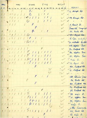
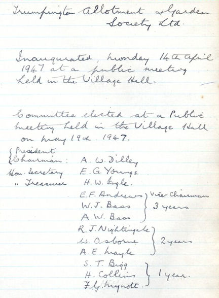
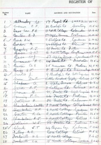
We have access to the archives of a few local clubs and societies. Here is the register of the Trumpington Friendship Club for over 60s, for 1955 and 56. Names and addresses, all helping to fill out the picture of village life. And the minute book and register of the Trumpington Allotment Society.
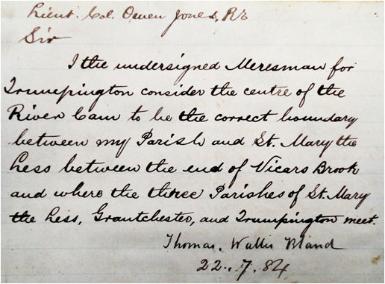
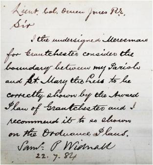
Bits and pieces can be found all over the place. On a trip to the National Archives at Kew I had a look at various documents that came up on my computer when I searched for “Trumpington” before going. Among them was a little booklet in the files of the Ordnance Survey, entitled “Perambulation of the Boundaries between Trumpington and (the various surrounding parishes)”, and dated 1884. This was so that the OS could be absolutely certain that the boundaries on their maps would be in precisely the right place, and among the various sketch maps and descriptions were these two pages.
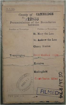
The archival resources also included a signed statement about the boundary with St Mary the Less, written by Thomas Wallis Bland, “Meresman” for Trumpington. Bland was the farmer at River Farm, and also the innkeeper of the Green Man. A meresman is “a man who decides on the exact boundaries of a parish, etc.” And on the right, incidentally, a similar statement about the Grantchester boundary with Little St Marys, signed by their meresman Samuel Widnall, who five years later wrote the little book Reminiscences of Trumpington Fifty Years Ago.
This information has now all been pulled together into a searchable database: People in Trumpington, with an introduction on this website.