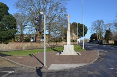
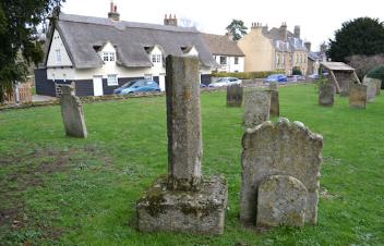
Cross Hill and Trumpington War Memorial. Photos: Andrew Roberts, 17 February 2015.
The open space at the junction of Trumpington High Street and Church Lane is known as Cross Hill. Now the location of Trumpington War Memorial, for hundreds of years it was the site of the Village Cross.
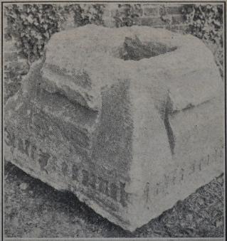
Rev. A.C. Moule and Percy Robinson wrote contemporary accounts of the discovery of the base of the village cross on 17 August 1921. Moule reported ” When foundations were being dug for our rather belated war memorial last Wednesday morning, a large stone was struck only a few inches below the surface of the road. The workmen were filling in the earth they had removed, and would soon have begun to lay concrete over this stone, when the schoolmaster, Mr. P. R. Robinson, happened to pass by, and saw at once that the stone was of considerable age and interest. Thanks to his prompt report of what he had seen and to the interest of Dr. W. W. Wingate, the stone was carefully lifted from its place, and proved to be the base of an old cross …” (Moule, 1921). Percy Robinson added “Mr. Nathan Scott, who was entrusted with putting in the foundation for the present memorial, was about to cement it over when I happened to pass. I told him it would have to be removed …”. Moule reported later that “the top has been much damaged by the pickaxes of road-menders, and has in recent years been partly covered with tar, so near the surface of the road was it” and that “one corner of the stone has been very roughly knocked off by workmen who were laying a gas-pipe about 20 years ago” (Moule, 1922, p. 103-04).
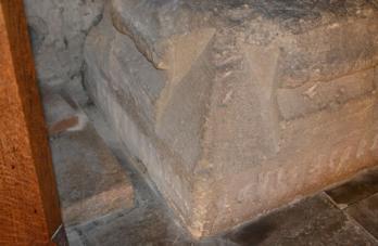
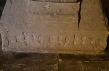
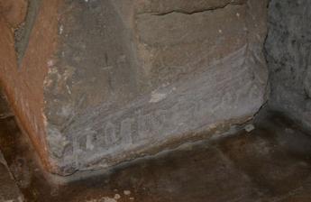
The base of the village cross is of Barnack stone, with a socket for a shaft and the inscription “Orate pro animab[us] Joh[ann]is Stokton et Agnetis uxoris ei[us]” [Pray for the souls of John Stokton and of Agnes his wife] (Carr, 1973, p. 28, Moule, 1921, Moule, 1922, p. 104, RCHM, 1959, p. 296). From this evidence, Moule and others established that the village cross was erected soon after 1476. The inscription names John and Agnes Stokton, who probably lived in a house on the north west side of Church Lane (in the area now occupied by the Lord Byron Inn (previously the Unicorn pub)), possibly in a house called “Reynolds” (Carr, 1973, p. 28, Moule, 1922, p. 107). Stokton may have been a farmer (in the 16th century, there was a Stokton Farm of 100 acres) (VCH, 1982, p. 260). John Stokton was referred to in the Subsidy Rolls in 1450 but had died before 1476 (a deed held by Jesus College shows that Agnes Stokton was a widow, alive in 1476) (Moule, 1922, p. 106-07). The ‘Stokton’ name continued in use: in 1950, the four houses just west of the school in what was then called School Lane (now Grantchester Road) were called Stockton Cottages (Electoral Register).
The base would probably have been placed on one or more steps (Carr, 1973, p. 28, Moule, 1922, p. 102). Moule cautions that the base may not have been found in its original location, as there was no evidence of the steps (Moule, 1922, p. 108).
Crosses should have been removed and defaced according to an Act of 1643 (Carr, 1973, p. 28, Moule, 1922, p. 108-9), but the base must have survived (possibly buried).
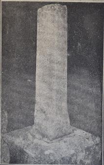
Part of the shaft of the cross may have been moved to the churchyard. In his report about the discovery of the base, Moule writes “In the top is the socket, about 1ft. square, into which the shaft of the cross fitted. A large part of the shaft has long been kept in the churchyard, though no one knew the history of it with any certainty, and a fragment of the bottom of it was found with the base” (Moule, 1921). Percy Robinson added “In the churchyard opposite the north door is a stone containing a shaft, which is said by some to be the original of the village cross, but the cross is missing. The shaft is about the same size.” This shaft is still in place, near the north door into the church.
Ambrose, Tom (2006). St Mary & St Michael Trumpington . Page 4.
Carr, Edith (1973). ‘Trumpington: a Cambridgeshire Village’. In People and Places. An East Anglian Miscellany . Pages 8-67. Lavenham: Terence Dalton Ltd.
Moule, A.C. (1921). ‘Old Wayside Cross: interesting Trumpington discovery’, Cambridge Chronicle , 31 August 1921, p. 7. See text .
Moule, A.C. (1922). ‘Some Trumpington Inscriptions, with Special Reference to the Base of the Old Village Cross’, Proceedings of the Cambridge Antiquarian Society , 24, p. 95-109.
Pevsner, Nicholas (1970). Cambridgeshire. The Buildings of England .
Robinson, Percy (1920s). Cross Hill and the base of the old village cross. See copy of notes .
Royal Commission on Historical Monuments (England) (1959). An Inventory of the Historical Monuments in the City of Cambridge. Part II . London: HMSO. Page 296.
The Victoria History of the Counties of England (1982). A History of Cambridgeshire and the Isle of Ely, Volume VIII. Armingford and Thriplow Hundreds . Trumpington , page 251.
Widnall, S.P. [Samuel Page] (1889). Reminiscences of Trumpington Fifty Years Ago . Grantchester: the Author.
Local History Group web pages: History of the Parish Church; John and Agnes Stokton .
The base of the cross and the shaft in the churchyard”, Cambridge Chronicle , 31 August 1921, p. 7.
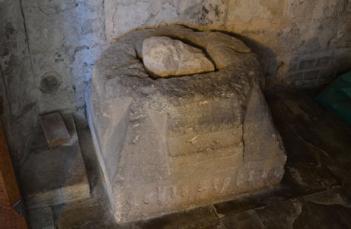
Soon after its discovery, the base of the cross was moved to the Parish Church (Moule, 1922, p. 101). Percy Robinson wrote “being pressed for time I saw Mr. William W. Pemberton, told him of the discovery, and he promised to have it removed to a safe place. The Parish Council took upon itself the ownership of the stone, and offered it to the vicar and churchwardens on condition it was placed in the church, where it now stands.” The base is still in place, underneath the table under the organ loft near the west door entrance into the church.
The stone base of the former village cross, known as the Stokton Cross, Trumpington Church. Overview and 3 faces. Photo: Andrew Roberts, October 2011.

The possible shaft of the village cross in the churchyard. Photo: Andrew Roberts, 2 January 2019.
The placing of the cross at the ‘Cross Hill’ location suggests that the focus of the village may have moved from the area around the Church to this more north easterly area by the 15th century.
The cross may still have been in place in the late 17th century, as there was an entry in the Vestry Audit Book dated April 1691 with “And lastly wee doe order an Exact Coppy of these presents to be forthwith written out; and affixed on the publick Crosse of the Town of Trumpington” (Moule, 1921, Moule, 1922, p. 104, 108, Vestry Audit Book transcription). The cross may have survived into the mid 1700s. Writing in 1763, the antiquarian, W. Cole, referred to an old house “formerly standing near the Cross, still standing in the Angle between the great London Road and that leading to the Church from Cambridge” (Parish Magazine, August 1926).
The shaft of the cross does seem to have disappeared before the early 19th century, as the cross was not marked on the Inclosure Map in 1804.
However, the Cross Hill location seems to have remained as a focus for the village. In his reminiscences of Trumpington in the 1830s, Samuel Page Widnall uses an illustration of the old blacksmith’s shop, which was to the north of the open space, with the village stocks to its left (Widnall, 1889).
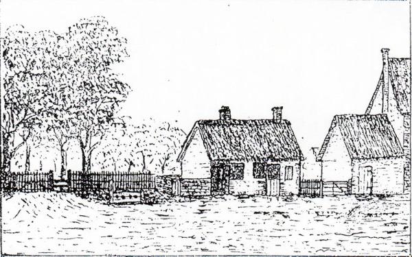
The sketch of the blacksmith’s and the stocks in Widnall’s recollections.
When the park gates were erected at the entrance to Trumpington Hall in 1855, the smithy, stocks and village pound were removed (The Monthly Magazine for … Trumpington, September 1923). Widnall wrote in 1889 that “The blacksmith’s shop in those days was a thatched building that stood near the avenue gate, the site is now planted with trees and shrubs, at the south end was the village pound, and between this and the avenue entrance was the stocks and whipping post; at the north end of the smithy were the yard and stables of Arthur Cambridge, a carrier …” (Widnall, 1889).
The name ‘Cross Hill’ seems to have survived, although it was not recorded on the Inclosure Map or on Ordnance Survey maps until after the War Memorial was placed in that location in 1921. Soon after the erection of the War Memorial, Percy Robinson referred to Cross Hill as “the name given to the piece of land at the junction of the Grantchester and Trumpington main Roads. It no doubt derives its name from the fact that the old Village Cross stood on this site.”