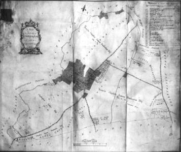
1804 inclosure map, with field names. Percy Robinson collection.
INCLOSURE AWARD MAP. 1804.
This is interesting in that it gives us some of the old names by which the land was known.
From Trumpington Hall, on the east side of the road, the land was called Cambridge Field to the Vicars Brook.
From Anstey Hall to Hauxton the land was called Hauxton Field.
On the west side of the road, reaching from Shelford Road to near Vicars Brook, the land just behind the houses was called Moorfield, whilst further westward it was known as The Moor. Situated on The Moor was Foulden Hill, but it “appears to have disappeared”. Behind the Moor was Great Kneighton, and to the south of it Little Kneighton.
Behind the Cemetery the land was called South Croft, and further south Hauxton South Croft.
The land by the river was known as The Fens.
Inclosure award started 1804, signed 1809.
Scanned from Percy Robinson’s original typescript by Howard Slatter.
Following his appointment as Head Teacher of the Church School in 1908, Percy Robinson built up an extensive knowledge of Trumpington’s history. One of his individual notes from the 1920s is about the 1804 map supporting Trumpington Inclosure Award, reproduced below.