Anstey Hall Farm barns and dovecote, c. 1900s. All photographs are from the Percy Robinson Collection.
Following his appointment as Head Teacher of the Church School in 1908, Percy Robinson built up an extensive knowledge of Trumpington’s history. His main note is about ‘A Trip Through Trumpington’, originally written in the 1920s, reproduced in full below.

The original of this topographic account of Trumpington is a typescript which dates from the 1920s, with a few handwritten additions up to the late 1930s. When Percy Robinson’s son, Reginald Robinson, gave the text to Nicholas Thistlethwaite in 1995, he also brought 69 photographs (see the introductory page ). The majority of these photographs have been incorporated in the body of the text, where there is a reference to their subject. There are a few photographs that we have not been able to correlate with the text and these are included at the end of this page. There are also a number of references to photographs within the body of the text where the photograph was not included in the group brought by Reginald Robinson (when Percy Robinson gave a version of his lecture in 1931 , it included 81 photographs). Captions for the photographs have been added by Andrew and Wendy Roberts, based on the information in these notes and other sources including articles and photograph captions in the Cambridge Chronicle newspaper (including the 1931 version of the talk) and catalogue records for copies of some of the photographs held by the Cambridgeshire Collection.
At the Group meeting in April 2019, Howard Slatter and Edmund Brookes gave a talk Trumpington 100 Years Ago based on these notes, with additional comments to put the notes and photographs into today’s context. The additions have been included below, as ‘2019 update’.
A TRIP THROUGH TRUMPINGTON
——oOo——
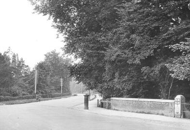
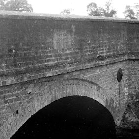
Entering the Parish from the north end, Cambridge, we come to the “Stone Bridge”. But why Stone Bridge? It is not built of stone but bricks, with a stone coping. Evidently it is short for Mile Stone Bridge.
Originally there was a ford here, and it was the duty of the people of Cambridge conjointly with the people of Trumpington to keep it in repair. The ford was known as Trumpington Ford.
Trumpington Road, the Stone Bridge and milestone.
2019 update: this is near the end of Chaucer Road, looking south towards Trumpington. Brooklands Avenue, which was only connected to Trumpington Road in 1923, is just off to the left.
An entry in 1485 states:
Money paid to ditchers at Trumpington Ford 13s. 4d.
In 1500:
Divers labourers of the town of Trumpington for cleaning a certain brook lying between the town of Cambridge and Trumpington 13s. 4d.
In 1502:
For the non-repair of Trumpington Ford the inhabitants of Trumpington were amerced 6s. and the treasurers of the town 3s. 4d.
In 1552 :
The rents of the fee farms of the town of Cambridge were remitted and part was ordered to be laid out in repairing the bridge at Trumpington Ford.
In 1399 John Fordham, Bishop of Ely, granted indulgences to such as should contribute to the repair of the road between Cambridge and Trumpington.
1563. Thomas Johnson, citizen and haberdasher of London, left 26s. 8d. to the mending of the highways between Trumpington and Hawston (Hauxton) Mills. There was no bridge then at Hauxton, only a ford.
1655-6. Still no bridge, and a traveller expressed gratitude in an entry in his diary to someone who allowed him to use his horse to cross the swollen river.
The Milestone is the first out of Cambridge and very large in size, being 8 feet high, and was erected on the occasion of the visit of George II to the University in 1728. This replaced a smaller one that was said to have been put there in the time of the Romans. This is the first of sixteen set up between Cambridge and Barkway in the early part of the 18th century. The cost was de¬frayed (£5 8 0) from funds left to Trinity Hall by Dr William Mowse. By his will dated 30th May, 1586, he left the surplus of his estate, after legacies, to Trinity Hall, to such charitable uses as his friend and executor Robert Hare should think desirable. The surplus amounted to £1,000, to which Hare added £600. He bought the Manor of Walpole, the rents whereof were to be applied to the repair of the highways in and about Cambridge, and especially towards Barkway. On these stones will be seen the crescent of Trinity Hall. On this particular stone is inscribed “one mile to Great St. Maries (not Mary’s) Church”. The coat of arms represents the arms of Trinity Hall impaling those of Dr. Mowse, a former master of the College, (viz. Or, on a Fess, between 3 Annulets in Chief and as many in the base–2 and 1–Sable, a Cross patee of the Field).
Dr. Harvey, a fellow of Trinity Hall, left a sum of money to keep in repair the mile stones to Barkway.
To commemorate the source of the “Causey-money” so used, the arms of the second of these benefactors were placed on the last stone at Barkway, and those of Dr. Mowse on the one at the Stone Bridge.
This slide gives us a view of part of the Trumpington Road, which is without doubt the best approach to Cambridge.
What a difference in the traffic of years gone by. Now motor waggons, etc. are rushing about and the villagers go to Cambridge in the motor ‘bus. Previously one might see geese, turkeys, etc. being driven to London, their feet being prepared by walking over tar and then sand. Bullocks with shoes on were no uncommon sight, and old residents in Trumpington remember the blacksmith of the village who used to make and fix them.
Old waggons drawn by eight horses conveyed produce to town. These had a cover at the back for passengers. Generally a dog was a necessary accompanist.
People later travelled by Coaches drawn by teams of horses. These were changed at various inns along the route. These inns had galleries round the yard, and the bedrooms opened on to a balcony. No doubt the Green Man Inn, also the Coach and Horses, and the Tally Ho were places of call.
Coaches left Cambridge as follows and passed through Trumpington:
2 a.m. Lynn Mayle.
6 ” ” Times.
7 ” ” Star.
9 ” ” Beehive.
10 ” ” Telegraph and Fly.
The driver of the latter was named Greenfield.
At midnight the Lynn & Wells Mail, and the Rapid passed.
The carriers’ carts were suitable for short journeys. The old Trumpington carrier was Mr. Arthur Cambridge who had stables at the North End of the village. Other carriers of Trumpington being Mr. Haslop, Galley, Dasley, Howlett. These carts were the places for news as I’m told the ‘buses are now. Well. When people meet they cannot simply look out of the window, they must talk. I well remember journeys in the old carriers’ carts.
ROADS.
Years gone by the Village Feast was a much more important event, and stalls and booths reached from the Stone Bridge on the East side of the road as far as the Tally Ho.
In 1610 the New River was made by the town and university to convey water to the town. It runs from Nine Wells, and in the Shelford Inclosure Act, 1834, it states that not more than three acres at Nine Wells is given to the Town and University of Cambridge.
In 1856 a bye-law was passed by the town making it a punishable offence for anyone polluting the stream. For an offence a fine of ten shillings may be imposed.
The first stone of Hobson’s Conduit, that now stands at the corner of Lensfield Road, was laid on Market Hill in 1614. In 1855 the new Conduit was erected and the one of Hobson’s removed to its present site.
The land on the east side of the road was the property of Trinity College.
In 1852 Mr. William Bennett occupying a farm at Trumpington belonging to Trinity College, (but leased to the trustees of the late F. C. J. Pemberton), erected a barrier across the western bank of the New River at a point where the parish of Trumpington joins the Borough. The Corporation gave him notice under their common seal that unless such barrier were taken down they should remove the same by force both for themselves and on behalf of the University. The University, however, on the 17th March gave notice under their seal that “they expressly dissented from the act intended to be done on their behalf by the Corporation”, wherefore no further steps were or could be taken in the matter.
Crossing the Stone Bridge, on our right is Chaucer Road, a private residential road named after Geoffrey Chaucer, but whether he ever was a Cambridge man is doubtful.
Passing along we come to Latham Road, named after Dr. Latham, sometime Master of Trinity Hall. He lived at Southacre.
On the opposite side of the road is Newton Road, named after Sir Isaac Newton who was at Trinity College.
Further along is Bentley Road, named after Richard Bentley, sometime Master of Trinity College.
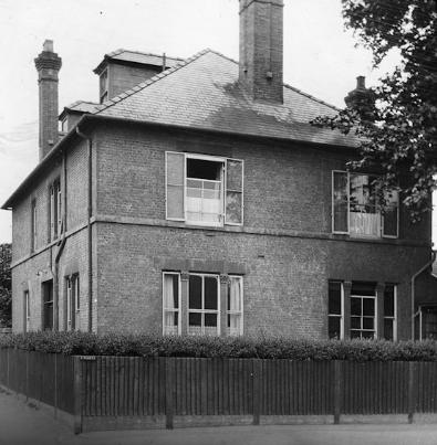
EVELYN NURSING HOME.
A nursing home known as The Hostel was carried on in Thompson’s Lane, Cambridge. It was in close proximity to a sweet factory and the Cambridge Electric Light Works. The place was anything but quiet and peaceful, and the continuous droning noise was very trying to the patients. When the lease expired the College to which it belonged required it.
The present site was formerly the home and garden, known as The Orchard, of Mr. Joseph Pryor, a Fellow of Trinity College. When he died the site was purchased by Mr. Charles Morland Agnew, and the Home erected by his orders.
Evelyn Nursing Home, with Sister Watson standing outside one of the rooms,1924.
2019 update: the nursing home was named after Morland Agnew’s mother, Evelyn. He had decided that what Cambridge needed was a really good nursing home and that he himself would provide it. Prior left The Orchard to Trinity College in his will, and in 1920 Morland Agnew bought it from the college. It is now replaced by the new Nuffield Health Hospital.
In the corridor may be seen a brass plate on which is the following inscription:
“The Evelyn Nursing Home was built in 1921 by Charles Morland Agnew, as a thank offering for the recovery of Evelyn, his wife, from an operation performed in Cambridge in 1918”.
The surgeon who performed the operation was Mr. Arthur Cooke, of Scroope House, (opposite Addenbrooke’s Hospital). The first operation in the Home was also performed by Mr. Cooke on a Trumpington woman and was successful, 1921. (Mrs. M. E. Robinson, wife of the schoolmaster of Trumpington was the first case.)
Sister Watson is the person seen in the photograph (taken in 1924), standing outside one of the rooms.
The Home is built on the latest principles and has the most up-to-date appliances.
Many who have entered the Home have much to thank Mr. Cooke for, and may I here say how grateful I am for his kindness and pay a tribute to his skill, for on two occasions he has performed operations, (successful in each case), once for my wife and later, 1924, for my son.
RIVER FARM.
This farm is now within the Borough Boundaries. It is very near the site of “Dam Hill” which was an old Roman Cemetery. The exact position is not known but was situated somewhere near here, probably between Chaucer Road and Latham Road.
Roman pottery, buckles, pins, etc. have been found about here, showing that it was occupied by them.
River Farm farmhouse.
2019 update: River Farm House is now number 19 Latham Road. The farm is part of the Pembertons’ Trumpington Farm Company estate; the house was used by tenant farmers until the 1970s.
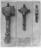
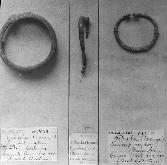
1: Anglo-Saxon artefacts. Left: Bronze fibula, Saxon, from Trumpington, Deck Collection, Cambridge Antiquarian Society, 1883 (now in Cambridge University Museum of Archaeology and Anthropology, number not traced). Centre: Cruciform horse headed bronze brooch, Saxon, from Trumpington, Deck Collection, Cambridge Antiquarian Society, 1883 (now in Cambridge University Museum of Archaeology and Anthropology, 83CAS518). Right: Bronze brooch, Anglo-Saxon, from Trumpington, Deck Collection, Cambridge Antiquarian Society, 1883 (now in Cambridge University Museum of Archaeology and Anthropology, probably 83CAS520).
2: Roman and Anglo-Saxon artefacts. Left: 83CAS551, bronze bangle, Roman, Deck Collection, Cambridge Antiquarian Society, 1883, (now in Cambridge University Museum of Archaeology and Anthropology, bronze bracelet, Roman, from Trumpington). Centre: faint number, probably 83CAS507, bronze fibula, Roman, Deck Collection, Cambridge Antiquarian Society, 1883 (not traced in Cambridge University Museum of Archaeology and Anthropology catalogue). Right: 83CAS508, bronze fibula, Celtic, Deck Collection, Cambridge Antiquarian Society, 1883 (now in Cambridge University Museum of Archaeology and Anthropology catalogue, bronze annular ring brooch, ?Saxon, from Trumpington).
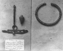
3: Roman and Anglo-Saxon artefacts, Chaucer Road. Left: A83CAS817, steelyard and weight, Roman, Deck Collection, Cambridge Antiquarian Society, 1883 (now in Cambridge University Museum of Archaeology and Anthropology catalogue, small bronze steelyard with 1 weight, Roman, from Dam Hill, Chaucer Road, Trumpington). Right: 83CAS552, faint writing, no label (now in Cambridge University Museum of Archaeology and Anthropology catalogue, bronze rope-twist bracelet, Roman, from Trumpington).
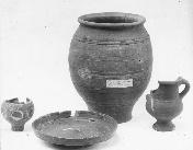
4: Ceramic pots (Cambridge Antiquarian Society).
“PARADISE”
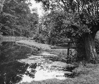
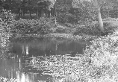
This view is of a strip of the winding Granta, and has the appropriate name of Paradise.
The view is taken from a point near the end of the fence that runs down to the river at the back of River Farm.
In summer hundreds of picnic parties spend a happy time in this neighbourhood.
Christopher Anstey, the poet, in the appendix to The Patriot mentions
“In Granta’s delightful and quiet retreat”.
Edmund Spenser also mentions the Granta in the Faerie Queen.
Christopher Anstey married a Miss Thompson of Trumpington and came into possession of Anstey Estate on the death of Mr Thompson; the last will left estate to a Mr Dowsing but owing to a deficit in the signing Mr Dowsing was given £1000.
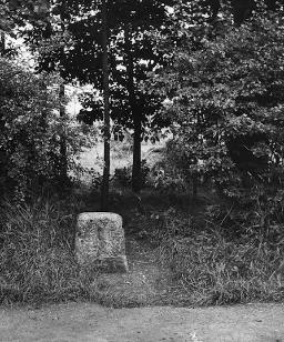
STUMP CROSS.
Coming from River Farm, and proceeding along the Trumpington Road, passing Bentley Road, on the left hand side about half a mile south of the Stone Bridge we find a stone in the hedgerow. This marks the end of the Stump Cross Turnpike Trust (Chesterford).
It is truly a stump now, for in 1922 it was smashed by an Air Force Motor Lorry. (This is quite excusable for there are no milestones in the air.) The mark where the stone was joined may be seen close to the ground.
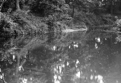
The River Cam at Paradise, from a point near the end of the fence that runs down to the river at the back of River Farm.
2019 update: we are looking north towards Cambridge, with Trumpington on the right and Newnham on the left.
Turnpike milestone, Trumpington Road, 1924, marking the end of the Stump Cross Turnpike Trust, damaged by a lorry in 1922.
2019 update: this milestone can still be seen if you search diligently, in the hedge near the end of Barrow Road. We unearthed it on one of our walks last summer (2018).
In the fields behind this stone, the Royal Agricultural Show was held in 1922. The land was soon under cultivation, for the crop of wheat now raised (1924) may be seen through the gap in the hedge.
There is also Red Cross at the extreme end of the parish. This no doubt marked another road boundary.
LEIGHTON.
A little further along the road we come to Leighton, the name of a house built by the late Mr. Robert Sayle, head of the firm of drapers, etc. in Cambridge.
The slide gives a view of the rise in the ground, and the house is built on the site known an Gibbet Hill.
[This photograph is not in the Robinson Collection.]
The last person to hang in the gibbet was tarred and feathered, and was so punished between the years 1757 and 1777.
At that time there was no plantation on the Trumpington Road, so a good view of the offender was obtained by passers by.
This information was obtained from Miss Bertha Moore who lives in the Mill Cottages along the Long Road. Miss Moore’s great-grandmother was born in 1757 and married at 18 years of age, and was a widow with two children at the age of 22 years. She saw the man in the gibbet. Miss Moore’s grandfather was born in 1777 and it was before this event.
Another punishment Miss Moore’s ancestor witnessed was a man tied to a tumbril cart and whipped round Cambridge.
LONG ROAD.
Previous to the Enclosure Award this was nothing more nor less than a drift, simply a grass track used by carts, etc., consequently it was sometimes in a very bad state.
It has had various names, Long Drift, Long Drove, New Road, Mill Road, and Cherry Hinton Road.
On the Enclosure Award Map it is named the New Road.
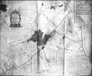
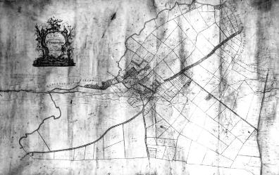
Left: 1804 inclosure map, with field names. Right: 1804 inclosure map.
2019 update: There are various versions of the Inclosure Award map, and between them they give a lot of information about Trumpington in the very early 19th century.
The people in the trap are the late Mr. George Duke, (farmer living along the Long Road); Mr. Flack his stockman, and Mr. Flack his son who acts as coachman. Over the hedge on the left hand is Mr. Marshall, known by the sobriquet of “Doggy”.
[This photograph is not in the Robinson Collection.]
THE MILL ON CHERRYHINTON ROAD [LONG ROAD].
This was situated on the Long Road, or by whatever name it was called, at the back of the piece of ground between the Long Road and North Terrace, and behind the garden of Dr. F. H. H. Guillemard, who now lives in the Old Mill House.
From the corner at Trumpington Road to the allotments was formerly one property, the owner being a man named Badcock. It was afterwards sold in three lots.
The black gate at the end of the cottages, the last of which is inhabited by Miss Moore, was the beginning of the road to the Mill.
The mill was built in 1812 by a Mr. Brand. It was bought in 1836 by the father of Miss Moore for £600, and demolished in 1898.
People in the picture: Mr. Hayden at the gate, Mrs. Hayden in the cottage nearest the mill, Mrs. Sarah Careless at the door of one of the cottages, and the children playing are named Marshall.
[This photograph is not in the Robinson Collection, but the Cambridgeshire Collection does have a photograph “Windmill near the junction of Long Road (Mill Road) and Trumpington Road, 1873”.]
Those cottages have been pulled down.
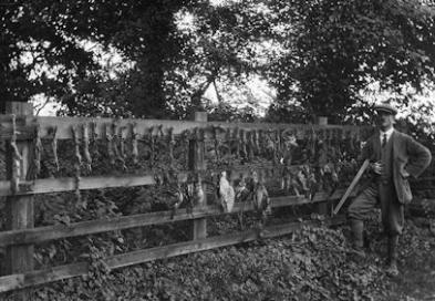
GAMEKEEPER’S GIBBET
This is situated at the corner of the track way that leads from the gamekeeper’s cottage to the fields where it touches the large plantation of trees.
To some the sight is repulsive, whilst sportsmen may have a different opinion. It is not often a gibbet such as this can be seen so near a town.
It shows the remains of weasels, stoats, hawks, jays and magpies, all enemies of game.
In the picture may be seen the “Lord High Executioner” Mr. Armond Cannell, the game keeper on the Pemberton Estate.
The gamekeeper’s gibbet, game strung up on a fence (with Mr Armond Cannell of Pemberton Estate).
2019 update: the gamekeeper’s cottage is 2 High Street, the last house on the left heading out of Trumpington village towards Cambridge, at the start of the tree belt or plantation. Armond Cannell is one of the men listed on the First World War Roll of Honour in Trumpington Village Hall’s Committee Room.
WORTS CAUSEWAY.
Standing with our backs to the Gamekeeper’s Cottage and looking in the distance across the meadow opposite, we see an old roadway that shows up white owing to its chalky nature.
[This photograph is not in the Robinson Collection.]
This is part of an old Roman road that used to run from the Icknield Way, crossing Hills Road, to the ford at Trumpington. It crossed the Trumpington Road somewhere hereabouts at right angles, and ran by the Gamekeeper ‘s Cottage to the ford and out by Ball’s Grove, Grantchester, then past the “Rose and Crown” and along behind Grantchester School.
This is probably the road mentioned by Charles Kingsley in “Hereward the Wake”, in which he describes Hereward as passing along after his escape from William of Normandy when he had played the potter.
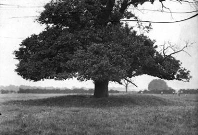
ELM TREE MOUND.
I have given it this name for it is an elm tree on a mound.
It is situated at the back of the thatched cottages on the east side of Trumpington Road.
This is supposed to be the site of some old Roman fort that was probably an outpost of the garrison at Grantchester, situated on the side of the then causeway to guard the approach to the ford. Formerly there was a ditch round it.
Many antiquarians are anxiously waiting for the tree to die, but it appears to be like a cat with nine lives. Widnell in his book “Reminiscences of Trumpington” mentions it as being dead. Three years ago it appeared dead, but last year, 1923, the lower part certainly was in a flourishing condition.
Giant elm tree in fields, Elm Tree Mound (behind the telephone exchange), 1923.
2019 update: The mound is still there today, now surrounded by a brick built retaining wall. The elm tree is long gone, replaced by a horse chestnut. It is within a former BT site, now abandoned, between Alpha Terrace and Wingate Way, with access from the High Street. This is a hot tip for the next residential development in Trumpington – but what will they do with the mound? The piece of land on which it stands was known two hundred years ago as Kings Close, so there is a ready-made name for any new buildings.
ST. MARY’S
Why this house? Simply because it is built on the site of John Cummings’s School. Cummings lived in Alpha Terrace, and his school had a reputation.
St Mary’s House, on the site of John Cumming’s School.
2019 update: this was actually James Cumings, not Cumings John. He was granted a 3 acre parcel of land here just before Inclosure in 1809, in exchange for a plot at Dagling End. He turned the then existing house into a school, and had Alpha Cottage built for himself next door. St Mary’s was built about 1885 for Miss Frances Sayle, daughter of Robert Sayle. Robert Sayle founded the draper’s shop in Cambridge which eventually became John Lewis. He himself lived in Trumpington Road, in the house now occupied by the Perse Preparatory School.
Widnell gives the following account of the school. There were boarders at the school and he was one. They had to stand for meals and had bread and milk for breakfast from basins.
The room was large and square with two windows in the south and two in the east wall.
The master’s desk was on a raised dais, and he sat on a stool. There were the usual cupboards, etc. A bundle of quills served the purpose of pens. A note says S. P. Widnell weighed 4 st. 3 lbs, 25th July, 1834. (Evidently Trumpington can claim some right to having introduced Medical Inspection in School. I remember, when it was introduced officially one or two indignant parents coming to me asking “why I had been looking into their children’s heads.”)
Children were punished with an “instrument of torture” called a spanker, (necessary even in those days). This was a piece of wood about one foot long with a circular piece at each end. One circular piece had a hole cut in it and was used for serious offences, and was said to raise a blister when properly administered.
Money was left for the school, and was no doubt obtained from the Charity land at Bottisham.
Village children were on a form at the lower end of the room. The desks were fixed to the floor, whilst the playground was at the back of Alpha Terrace. Of course there was a bell. Widnell relates that on one occasion when eating his dinner he was stung by a wasp, and consequently called out; for this offence he was punished but does not state which end of the spanker he received nor where administered. Children had half-day holidays on Wednesdays and Saturdays and usually had to go for a long walk.
Cummings had a farm on the Shelford Road near “Dead Woman’s Bush”, and an orchard at Dangler’s End.
Dangler’s End consisted of cottages and gardens in the park near Trumpington Hall. The well that supplied water to the houses is still there, but the pump has had to be replaced. Mr. J. Medlock was the last to live there.
On a wet day a barber visited the school; oil for the lamps was kept under the master’s desk.
They kept a canary at the school, and when it died he tells of the burial. A cigar-box was the coffin, and sheep bells were used for tolling.
Copy books were used to write in, and a specimen of writing probably done in this school is in the Fitzwilliam Museum. It is the work of William Marshall, and was done in 1793. (Having seen it I can testify that it is very well written.)
On Sundays they went to church. and had a pew on the south side. They had the old square pews in the church then. There was a Singing Gallery at the west end of the church, and John Nichols the blacksmith was in front leading the singing. Various instruments were played, such as violins, flutes, etc.
Looking east along Alpha Terrace, late 1890s or early 1900s.
2019 update: Alpha Terrace was built from about 1880 onwards, well after Alpha Cottage, on part of James Cumings’ land.
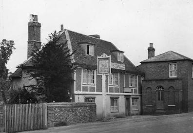
GREEN MAN INN.
The old sign has been taken down. The landlord now is Mr. Charles Hering. On one occasion when referring to the trade being done, and the old sign, he exclaimed, “Ah. It is I who am de green man.” meaning that he had been “taken in” when applying for the house, and that the trade was not as he anticipated it would be. Mr. Hering can be seen in the picture.
The Green Man pub, with Mr Charles Hering, 1920s.
2019 update: this inn was originally a 15th century timber-framed hall-house. In the early 1900s, the Green Man was well-known for its shaded tea garden, complete with tree-house. It was almost certainly known until the late 18th century as the White Lion.
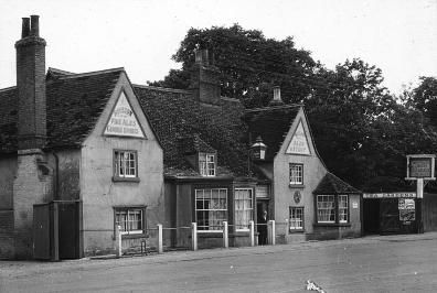
COACH AND HORSES.
The present landlady is Mrs. Howard Pare. 1924
No doubt both these places were much used in the old coaching days. The Green Man Inn has a very large yard with plenty of stabling, whilst the building by the Coach and Horses now used as cowhouses was formerly a malting.
The Coach & Horses pub.
2019 update: the Coach and Horses was known in the 19th century as the Black Swan. It is now the Wok n Grill. The part of the premises nearest the road used to be a separate cottage; in fact the address of the present Wok n Grill is now both 18 and 20 High Street, number 18 being the cottage.
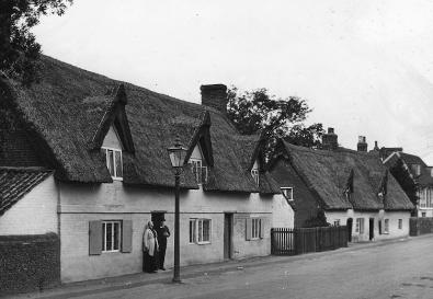
THATCHED COTTAGES
These picturesque buildings are evidently very old.
On the slide may be seen the figures of the late Mr. and Mrs. Charles Wilson at the door of the cottage where they have lived for over thirty years. Even at his age Charles loves a “fag” (cigarette), and may often be seen enjoying one.
The road has been raised, now have to go down step.
Two semi-detached thatched cottages, Trumpington High Street, probably in the late 1910s or early 1920s. Based on the 1911 census, the left part of the left hand house was probably the home of the Wilson family in the 1910s, and the figures in front of the door are Martha Saunders Wilson (aged 55 in 1911) and her husband Charles Wilson (aged 61 in 1911) (confirmed in the Robinson notes, p. 23). The right part of the right hand house was the home of the Mynott family in the 1910s (Francis Frederick and Elisa Mynott and children). The Coach & Horses pub is far right.
2019 update: three of these four cottages, next to the Coach and Horses, are still there today. The third one from the left was demolished in about 1945.
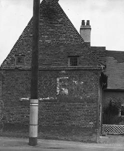
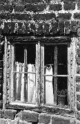
SMALL WINDOWS
This house is next to the Red Lion and is endways to the road.
The tiny leaded windows are very old as is also the house. They are not made to open, one gives light to the staircase and the other to a bedroom.
It is hard to understand how people could live in such a room. What the modern “flapper” would do in such a light when she has to “titivate” with powder and paint it is hard to think. Her hair would not trouble her so much, as most of the damsels (and some of the old young ones) have it “bobbed” or “shingled”.
House and Red Lion demolished April 1936.
Window tax imposed 1695. Repealed 1851, 5/- per window.
Small windows in side of house next to the Red Lion, endways to the road.
2019 update: the Red Lion (just visible to the right) and this house stood almost opposite the War Memorial, on the site of what is now Lambourn Close. They were demolished in 1936, and a new grander Red Lion was built in their place. That in turn was replaced by the current neo-Georgian housing (marketed as Trumpington Court) in the 1970s.
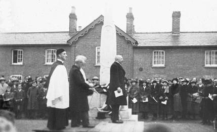
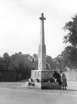
TRUMPINGTON WAR MEMORIAL.
……….oOo……….
This is the Village Tribute to its Honoured Dead, and has 36 names on it.
The carvings are symbolical rather than picturesque.
One slide gives a view of the Memorial, the other shows the unveiling ceremony. Standing next to the Memorial is Mr. Adeane, Lord Lieutenant of the County, who unveiled it. Others are the Rev. Robert Gregg Bury, Litt. D., a former vicar; Rev. Arthur Christopher Moule, M. A., vicar; and Mr. Walter Campbell, Pastor of Trumpington Free Church, who took part in the unveiling ceremony.
An account of the Memorial and the Unveiling Ceremony is attached [see War Memorial page].
Left: the unveiling of the War Memorial, 11 December 1921. Right: Cross Hill, the War Memorial and Church Lane in the 1920s.
2019 update: note the original road layout, with Church Lane passing behind the War Memorial. Also the cottages with the mansard-style roofs behind, now replaced by those built in the 1960s.
THE VILLAGE SMITHY
The old blacksmith’s shop was occupied by John Nichols and stood on a site near the present lodge house of Trumpington Hall. The slide shows a sketch by Widnell from memory of the place. Not only were horses shoed but cows and bullocks. The latter had to be driven very long distances to market, hence the necessity.
Copy of the sketch of blacksmith’s and the stocks in Widnell’s recollections.
2019 update: Samuel Widnall lived in Grantchester, but attended James Cumings’ school here in the 1830s. In 1889 he published his book “Reminiscences of Trumpingon Fifty Years Ago”, and this drawing of his appears on the last page of the book.
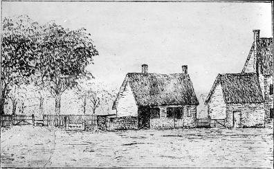
To the south of this place was the village pond, probably situated near the north-west corner of the Unicorn garden and on the piece of ground now used by the school gardening class. I have been informed by old residents that there was a pond on this spot. Between the black¬smith’s shop and the pond were the stocks and whipping-post.
The next slide shows the smithy on a new site. The date is [1855]. Mr. Elijah Lawrence, (Junr.), is now the blacksmith, and he took over from his father-in-law Mr. Elijah Lawrence who is seen sitting in the cart, died 1931, aged 89. Mr. Ben Stone one of the assistants to Mr. Lawrence is near; he also holds the position of parish constable.
The blacksmith’s workshop at the junction of the High Street and Church Lane, c. 1900.
2019 update: the smithy was demolished in 1985, much to the anger of many local people. Bidwells estate agents building (Bidwells Stone Cross) now stands in its place.
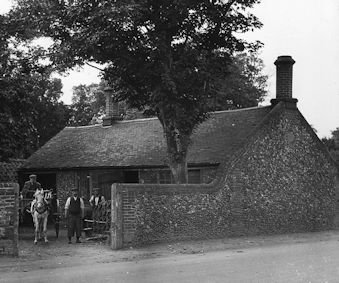
It is interesting to note that a Mr. Charter who was blacksmith at Trumpington made a bicycle, and entered and I am told won a race on it. The race was almost the first big race on ordinary cycles in England, and was run from the milestone near Cromwell House to the Stone Bridge. Another competitor was a Mr. Crossley, dentist, of Downing Street. Mr. Charter had an old tricycle and converted it into an ordinary. The race attracted quite a large number of people.
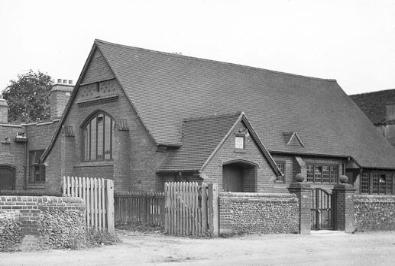
VILLAGE HALL.
This was built in 1908, and declared open by Sir Clifford Allbutt. It was enlarged in 1923-4, mainly through the generosity of the Pemberton Family, and the new additions were also declared open by the above-named gentleman.
A separate account is attached [not traced].
Trumpington Village Hall, after the 1924 alterations, with the entrance to Manor Farm to the left.
2019 update: this is one building that has not changed much over the intervening century, though the perimeter is now very different. Sir Clifford Allbutt, who was a distinguished physician, is now also commemorated in Allbutt Way, on the Clay Farm development.
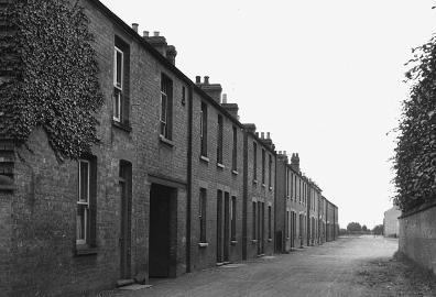
Cottages and yard, thought to be Whitelock’s [Whitlock’s], High Street, in the 1880s.
2019 update: this photo is one of the Robinson slides but there is no reference to it in his notes. We believe that this was the earlier version of the Whitelocks cottages (Whitelocks Yard) which stood on the site of the present Whitlocks building half way between Church Lane and Maris Lane. They were at least partly rebuilt in about the 1880s, then replaced by the first set of Whitlocks flats in the 1960s. The present Whitlocks building was put up this century.
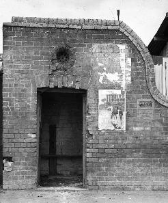
THE OLD LOCK-UP
This gives a view of the old lock-up in which prisoners were placed until it was convenient for their removal. Possibly someone can remember who the last one was.
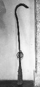
The prisoners were provided with a seat but were kept in position by irons. These can be seen in the picture. The irons are now in the Folk Museum given by Mr W. W. Pemberton.
The village lock-up. Irons were donated to the Folk Museum by W.W. Pemberton.
2019 update: the lock-up was later incorporated into the bicycle shop and garage run by Mr Harry Newell. That was eventually replaced by the present Shell garage.
By the lock-up was the Village Pound in which straying cattle were placed. There used at one time to be two pounds. Pinder.
The site of the pound is now used as a cycle shop tenanted by Mr. Harry Newell, a very obliging fellow, who has removed the old gates of the pound and covered the site in for business purposes.
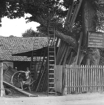
TIMBER YARD
This slide shows the wheelwright’s shop used by Mr. Edwin Smith and his sons. In the award map the site is shown as a carpenter’s shop.
Mr. Edwin Smith and his son Gordon Millar Smith are to be seen amongst the ladders, wheels, etc.
The yard is next to the pound and runs behind it.
One of the old village industries fast dying out.
E.J. Smith & Sons, Carpenters, Wheelwrights and Undertakers [Edwin John Smith and his son, Gordon Miller Smith], Trumpington High Street, 1920s.
2019 update: and now of course quite gone. This is also under the forecourt of the Shell garage.
HOBSON’S MONUMENT
Hobson was a great benefactor to the town of Cambridge, and he also arranged that children from Trumpington might compete for free places at the Perse Grammar School. At the present time (1925) there are three lads from Trumpington attending the school as Free-Placers. One of these, Frank Haynes, has since obtained a Classical Scholarship at St. Catharine’s College and is in residence. Later passed Classical Tripos.
Hobson used to be a carrier. He had stables in Trumpington Street somewhere near the site of the “Little Rose”. Here he kept about forty horses, and let them out on hire to undergraduates. Of course the men wanted the horse they fancied, but he would have no picking and choosing, they had to take the next in order, otherwise Hobson said, “That or none”. Hence the origination of the saying Hobson’s Choice.
He died in 1630 and left money for scholarships and apprenticing poor boys. He gave also the site of the “Spinning House” where the Police station now stands.
The monument is at Nine Wells just in the parish of Shelford, but it is hard to say how many wells there are. I tried to count them but could only find springs. The water is carried along the Vicars Brook, and supplies the New River, and the Conduit on Market Hill, also the gutters in Trumpington Street and St. Andrew’s Street. The old Conduit stands at the corner of Lensfield Road, and this place is sometimes spoken of as Waterhouse Corner. The name Samuel Potto was removed in 1938 and the name Edward Potto substituted. This alteration was made by Mr Leach of Coleridge Road.
The monument at Nine Wells commemorating the building of Hobson’s Conduit, 1920s.
2019 update: Nine Wells is now a local nature reserve. All the mature trees were planted in the winter of 1936-37, well after this photo was taken.
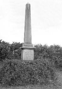
Hobson is buried in St. Benedict’s Church. The inscription on one side of the monument reads:
“The supply of water to Cambridge from the adjacent springs was first suggested in 1574 by Andrew Perne, Master of Peterhouse. The design was revived by James Montagu, Master of Sidney Sussex, and in 1610 carried into effect at the Joint expense of the University and Town.
Erected by public subscription 1861.
Charles Finch, Treasurer.”
NEW THATCHED COTTAGES
These were built in 1923 by Professor Browne who lives at “Firwood” on the Trumpington Road, and in them reside Mr. Albert Parker and Mr. King, his gardener and chauffeur respectively.
This gives an opportunity of comparing and contrasting the new with the old. May they last as many years as the old ones, for they are certainly very picturesque and ornamental to the village.
Thatched cottages on High Street, the homes of Mr Albert Parker and Mr King.
2019 update: the old thatched cottages that we saw earlier lasted well over 200 years. It is just possible that these ones might do the same; the last tenant there, Mrs Audrey King, who was the daughter in law of the Mr King just mentioned, moved out last year (2018). The two cottages have now been sold (2019), and are in separate hands.
WEIGHBRIDGE HOUSE.
This is where the old toll bar used to be, and users of the road had to pay towards its upkeep.
During this year (1924) an undergraduate returning from London ran his motor car into the door, knocking it clean out and also the window, and doing damage to the brickwork.
A new weighbridge for tolls was at the corner of Cherryhinton Road.
The Toll House and Weighbridge House, High Street, in the 1920s.
2019 update: another building which has changed little over the last century or more. Weighbridge House has recently been sold (2019) and there have been planning applications for development in the back garden.
MARIS’ LANE.
We pass along Maris’ Lane. This I have heard called “Mouse’s Lane”, and wondered where on earth it was, although I lived so near.
It is named after a Mr. Maris a farmer who lived where Mr. Tebbit now lives, opposite the yard entrance to Anstey Hall.
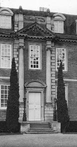
THE FRONT DOORWAY OF ANSTEY HALL.
……………oOo……..
You might travel the country through and have great difficulty in finding such an imposing doorway. Note the height of the pillars on either side.
Impressive doorway of Anstey Hall. The south side of Anstey Hall, c. 1920s.
2019 update: the doorway is more visible than in the past and the rear view can be seen from Anstey View on Trumpington Meadows.
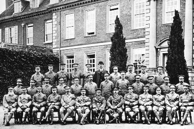
Trumpington Volunteer Training Corps at Anstey Hall, Trumpington, November 1915.
2019 update: this photo is in the Robinson collection without any accompanying comment but a copy appears in the Cambridge Chronicle of 10th November 1915, together with the names of most of the men. In the centre of the front row is Lieutenant George Ralph Cunliffe Foster, the owner of Anstey Hall and President of the TVC. Two to his left (our right) is the vicar, Rev Dr Robert Bury, who was vice-president, and on his left is Percy Robinson, Section Leader and Sergeant. We have managed to identify all but three of these men, see the Volunteer Training Corps page.
Mirror, beech and chestnut trees, stones.
These are situated near the front gates of Anstey Hall. This slide will appeal to ladies I am sure, if only for the mirror. I have many times smiled at their antics in front of it; I even saw a farmer standing opposite it the other day, and when I spoke of his vanity he said he was waiting for one of his men. Not a bad excuse.
The mirror at the entrance to Anstey Hall, corner of Maris Lane and Grantchester Road, looking past 20-22 Grantchester Road.
2019 update: probably not a comment you would hear today!
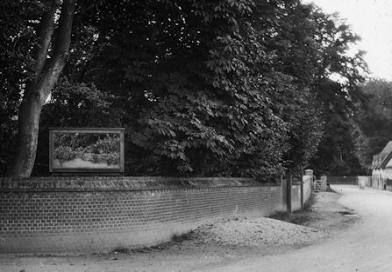
This appeals to me in a very different manner. (I might crack it if I stood gazing at it.) It shows a combination of human forces endeavouring to get the school children into trouble, and the schoolmaster an unenviable name. We say, “Lead us not into temptation”, and I make the children say it too. First someone plants the chestnut and beech trees, another erects the mirror, and the third brings the necessary “ammunition”. And this just outside the school where the children are sure to congregate.
There are two stone marks on the mirror, but I’ll not tell who caused them, otherwise you would laugh. Why shouldn’t you; as a matter of fact they were caused by the policeman’s two boys throwing stones.
THE SCHOOL
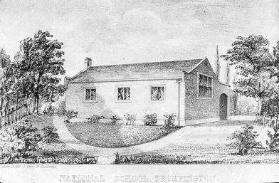
The slide is of the old school in 1842, very picturesque, enlarged 1903.
The school, other than Cummings’, was started by Mrs. Foster of Anstey Hall in a house opposite the Vicarage, (next to the one dated 1654), at present tenanted by Mr. William Chamberlain and family.
Print of the National School, built 1843.
2019 update: the school pictured here is the purpose-built National School in Church Lane. After the Fawcett Junior and Infant schools were opened in 1948, this school closed, and became the church hall, later and still today occupied by the Rainbow Nursery.
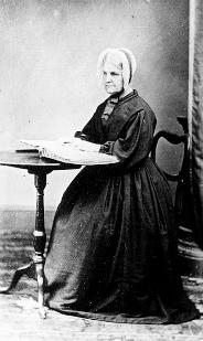
Miss Elizabeth Foster was greatly interested in a blind girl named Sally Farrington. Miss Foster learnt Braille in order to teach blind Sally.
A person apparently reading Braille. Miss Elizabeth Foster was said in the lecture to have learnt Braille in order to teach blind Sally Farrington.
2019 update: Elizabeth Foster was the eldest daughter of Ebenezer Foster, the banker who bought Anstey Hall in the 1830s; Sarah Farrington lived in Church Lane with her parents. We think this photo may be of Miss Foster in later years.
In 1830 we know that twenty-five children attended Grantchester School from Trumpington.
The present school was built in 1842, and the new room added in 1903. The schoolmaster’s house was an old thatched one built near the present front garden gate, and old bricks are still to be dug up. The names of some of the schoolmasters are Bridges, Stafford, Higham, (a bit of a dandy who drove a tandem and pair.) He had a door made in the stables of the Unicorn, (it is still there), in order to see the horses, so he said. Then followed our respected Mr. George Hutt who worked here for forty-four years. Miss Georgina Marshall over 50 years.
George Edward Hutt, the former Trumpington schoolmaster, died December 1925.
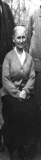
Miss Georgina Marshall, a teacher at the Trumpington school for over 50 years.
2019 update: George Hutt was Percy Robinson’s predecessor as schoolmaster, and seems to have played just as large a part in village life while here. Among other things, he was the Parish Clerk and the Census enumerator for over 30 years. Miss Georgina Marshall lived at Ivy Cottage then North Cottages for over 50 years.
The stables at the Unicorn have been used for various purposes; at one time an old fellow named Tom Wynhall lived near and used them as a butcher’s shop. It is said that he used to go to the villages round about and enquire of the farmers whether they had any ailing cattle to dispose of. They were then hurried to the Unicorn and slaughtered, and the meat sold locally. Possibly this accounts for the longevity of some of the inhabitants.
As we pass by now a noticeable effluvium pervades the atmosphere and tells its own tale, for the end stable has become a fried fish shop (not now).
Years gone by the tap room of the Unicorn was used as a laundry. It is said that the old thatch is there but the tiles have been put over it.
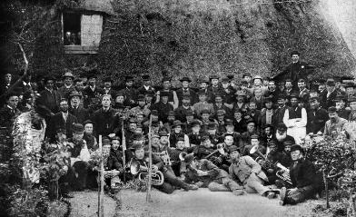
Picture of the Amicable Brotherly Friendly Society, dissolved 1911. Old thatched roof of Unicorn. Band.
A group of nearly 100 men gathered in front of the thatched Unicorn public house, with the Trumpington Brass Band in the foreground, most of whom appear to be wearing uniforms and caps, and the Amicable Brotherly Friendly Society (dissolved in 1911) in the background, and three figures looking on from a window. The photograph has been dated between the 1860s and the 1880s (probably early 1880s).
2019 update: this is a picture of the Amicable Brotherly Friendly Society was probably taken some time in the 1880s, and shows the old thatched roof of The Unicorn, now the Lord Byron. The front two rows contain members of the village band. The pub used to be a Trinity Hall property, and deeds at Trinity Hall show it going back to at least the 1540s.
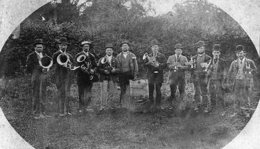
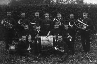
Left: Trumpington Brass Band, with 10 members standing in line, not dressed in uniforms, with a hedgerow and trees to the rear. The photograph has been dated between the 1860s and the early 1880s.
Right: Trumpington Brass Band in the Eighties [1880s], 13 members of the Band, dressed in uniforms with caps. The photograph by J.G. Simpson of Huntingdon Road, Cambridge, has been dated to the early 1880s.
2019 update: two more photos of the Trumpington Brass Band. The band survived until at least 1910; it is possible that it then became a casualty of the first world war.
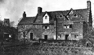
THE OLD HOUSE OPPOSITE THE SCHOOL
No one appears to know the date of this building. Evidently it was an important house when built, probably about 1572. It is of Flemish design, and many similar structures may be seen in Flanders. It is exceedingly interesting. Note the carved oak window frames, and the rings under the eaves of the house. These rings are said to have held large hooks which were hung at convenient houses, and used for the purpose of pulling off thatch when fires broke out. The slide of the one shown was taken from the hook that stands in St. Ben’e’t’s Church. Similar rings may be seen over one of the houses in Ben’e’t’s Street, Cambridge, and another opposite St Clement’s Church, the Master’s House of Peterhouse.
The ‘Old House’ with Dutch roof and rings under the eaves, Church Lane.
Carving on an oak window frame on the ‘Old House’ opposite the school.
Hook for removing burning thatch, St. Bene’t’s Church, Cambridge.
Rear elevation of the ‘Old House’ with Dutch roof, Church Lane and the Church tower.
2019 update: this house is in Church Lane, on the opposite side of the road from the Lord Byron and the old school. The rear view of the Old House shows it before renovation and extension in 1926. Census returns show that the smaller part, on the left hand side here, was a separate dwelling until that time.
Inside the house are some fine old beams, and formerly an old-fashioned oven, but this was removed when the house was restored, and a piece of leaden guttering passes through one of the attics. The house was restored in 1925 by Mr. William Pemberton. It was found necessary to brick in the wide open chimneys. Five windows had been filled in, no doubt when the window tax was in force. The windows and catches, to correspond with the original, of some of these were made by Mr. E. Lawrence the village blacksmith.
There is a quaint old design on the chimney that looks like a bunch of grapes or a baker’s twist.
“BUGGINGHAM PALACE”
This piece of ground is on the right hand side of the road as we go from The Old House in the direction of Cambridge in the Church Lane, and is situated between the houses now occupied by Mr. William Lowe and Mrs. Maud Smith.
An old tumbled-down thatched cottage stood on this site, and was occupied by a very notorious character, a Mrs. Sivill – Mother Sivill as she was called. She was supposed to be a witch and fortune-teller, and was credited with praying upon superstitious people. One evening two men were passing by when one said to the other, “I wonder if the old B— is at home.” “Yes! the old B— is at home; come in.” But the men went along the Lane in record time.
To old Mother Sivill belongs the credit of being the last person to be placed in the pillory at Cambridge, which stood close to the Old Market Cross near the end of St. Mary’s Passage and in front of Barrett’s shop. “Mother was placed in the pillory for one hour, turned round every fifteen minutes and pelted with eggs and other soft missiles as a warning for future fortune-tellers.
For a piece of silver she guaranteed to give your enemy trouble, by causing the chickens to have roup, his cattle the glanders, his pigs the fever, and his wife the creeping palsy or any other trouble.
Any who saw the havoc wrought by caterpillars on the crop of kohl-rabi the past season (1924) and who knew of the “old dame” might be tempted to think the evil spirit of the wicked one still haunts the place.
DANGLERS END
The place was so named on old village maps. This was formerly an important part of the village, and some of the old fruit trees are still to be seen.
The pump can be seen in the picture. Mr. Joe Medlock was the last to live here. No doubt in years gone by the old houses were the dwellings of the artisans who worked for the Lord of the Manor.
Pump at Dangler’s End.
2019 update: this part of the village was usually referred to as Daglen End or Dagling End. It is now completely enclosed within the parkland of Trumpington Hall, and the houses have all gone. It was accessed by a road called Daglen Lane from what is now the entrance to Campbell Lane opposite the parish church.
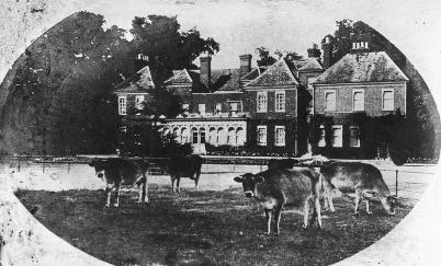
ENTRANCE TO TRUMPINGTON HALL.
This slide shows the two fine pillars that support the gates by which one enters the front court.
Trumpington Hall.
The grounds of Trumpington Hall.
Canon and Mrs Pemberton.
2019 update: Trumpington Hall has been the residence of the Pemberton family for over 300 years. Canon and Mrs Pemberton were Antony Pemberton’s great-grandparents, and lived at Trumpington Hall until Mrs Pemberton died in 1927.
Passing through Camping Close we come out by the Church.
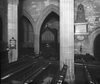
Interior of the Parish Church.
2019 update: Camping Close was the name for the part of the parkland nearest to Church Lane.
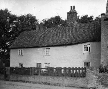
There are ancient thatched cottages (slide from painting made by scholar of Trumpington school 1929) opposite the Church, and a house near by has the date 1654 upon it. Until quite recently an old open fireplace could be seen in one of the bedrooms, but it is now bricked up. The staircase is of oak.
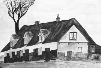
Sketch of 20-22 Grantchester Road, a painting made by a Trumpington School scholar, 1929.
18 Grantchester Road, marked with the date 1654, in the 1920s.
2019 update: as can be clearly seen here, number 20-22 was a terrace of three small cottages; since 1969 this has been a single house. Number 18 was originally two cottages. Historic England states that “the exterior was completely re-modelled in 1969 and bears little relation to its original appearance”. It is now a single property.
Corner of Grantchester Lane. View of valley. Barrington Hill in distance. High and low ground.
[This photograph is not in the Robinson Collection.]
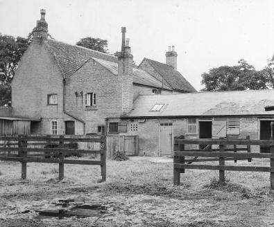
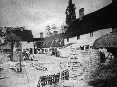
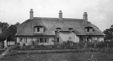
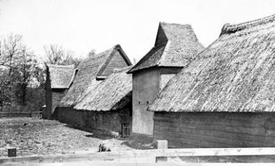
Thatched barns of Anstey Farm.
Anstey Hall Farm barns and dovecote, c. 1900s.
2019 update: now completetly renovated and remodelled and forming part of the Anstey Hall Barns development.
On our way to the river we pass the old roadway that no doubt led to the mill. The road at one time ran at the back of the cottages, and a pathway led through the plantation from the river and came out near the Church. This pathway was closed by the Enclosure Award 1808.
“Brazel” Bridge
Many have crossed this bridge -or stood upon it whispering sweet nothings – but few have noticed the tablet which states that it was “erected by public subscription in 1790”. The work was completed between 25th October and 4th December, at a total cost of £94. 10s. 0d. Previously the stream had to be forded, but there was a plank for foot-passengers some fifty yards lower down, Bast Bridge, and they went along the footpath aforementioned.
“Brazel” Bridge, the river bridge between Trumpington and Grantchester.
2019 update: this bridge over the Cam between Trumpington and Grantchester is usually called Brasley Bridge. It was rebuilt in 1952 and again in 2015, and now has a replacement plaque on it.
DEAD MAN’S HOLE
This slide gives a view of a bend in the river where the old backwater from “Chaucer’s Mill” entered the river. The ditch can still be seen.
The small copse of trees on the left bank is in the parish of Trumpington. The story goes that a man was found drowned here. Grantchester refused to pay for his burial, for it was said he was in Trumpington parish, and it fell to the lot of Trumpington. On this account Trumpington claimed the small portion of land.
Dead Man’s Hole, River Cam, Byron’s Pool.
2019 update: this triangular copse is small, but over an acre in size. This is about 100 metres downstream from Byron’s Pool, and is the only Trumpington land west of the Cam.
BYRON’S POOL
No one seems to know when this name was given to it. Byron, who was a poet of nature, is said to have made it his favourite spot for bathing. Another story says that when sitting meditating on the stone wall he tumbled headlong into the pool. Byron died in 1824.
The foundations of the Old Mill immortalized by Chaucer may still be seen in the picture. Chaucer (1340-1400) gives an account of the miller in the Reves Tale [Reeve’s Tale] of the Canterbury Tales.
Byron’s Pool in the 1920s.
2019 update: now another local nature reserve, with a fish pass taking both fish and aquatic invertebrates past the obstruction of the modern weir.
No doubt there used to be two mills, for the plantation is called Old Mills Plantation. There are three disused fishponds in it, and another in Mr. Foster’s meadow.
In 1470 Robert Attylbrigg was the miller of Trumpington.
Tennyson also wrote of the place in “The Miller’s Daughter” 1832
“I see the wealthy miller yet,
His double chin, his portly size.”
William Wordsworth in 1800 writes:
“Beside the pleasant Mill of Trompington
I laughed with Chaucer in the hawthorn shade.”
No mill. Grantchester Mill in its place. Late miller true to Tennyson’s description. “Shadow does not diminish”.
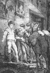
Sketch of the Miller of Trumpington? and youths outside a mill? From print dated 1727.
Whilst mentioning poets one must remember the young patriot Rupert Brooke who lived at the Old Vicarage, Grantchester, where Widnall lived. He wrote unpleasant things of the people of Trumpington, but we must put his remarks down to the privilege of poet’s license: “At Over they fling oaths at one, And worse than oaths at Trumpington.”
Volunteer Corps guarding bridge, few humorous incidents.
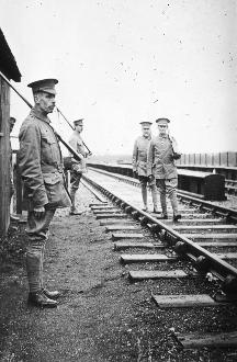
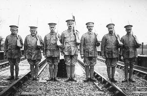
Trumpington Volunteer Training Corps guarding the railway line over the river bridge “Somewhere in Cambs.”, November 1915.
Trumpington Volunteer Training Corps standing at attention, guarding the railway line “Somewhere in Cambs.”, November 1915.
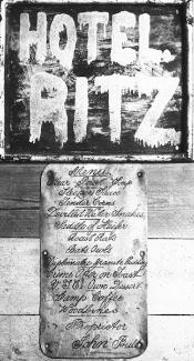
Hotel Ritz sign: “a sense of humour displayed by the War-time Volunteers, who tacked this imposing sign and the menu on their hut when they were guarding the Pile Bridge” (caption for this photograph when it appeared in the Cambridge Chronicle report on Percy Robinson’s lecturers in 1931). The sign had been on the Trumpington Volunteer Training Corps hut beside the railway bridge carrying the Cambridge-Bedford line over the River Cam, between Trumpington and Grantchester.
2019 update: these two photographs show some of the men of the VTC in action. The bridge shown here no longer exists, though you can see the approach to it in Trumpington Meadows Country Park, where the almost straight embankment stops abruptly just short of the river, and there is now a viewing platform. Sergeant Percy Robinson appears in both these photos. Items on the Hotel Ritz menu include: Sleeper Sauce, Tender Corns, Devilled Water Snakes, Saddle of Heiffer, Roast Rats, Bats and Owls, Diplomatic Granite Pudding, Crème Otter on Toast. Proprietor John Bull.
SQUANDERMANIA
Two huge mounds of earth may be seen in this slide, one of top soil and the other the sub-soil. These were placed here when excavations were being carried on for coprolites (reptiles, Mesolithic Period).
Coprolite diggings near Hauxton Road, late 1910s.
Boring commenced on 8th June, 1917, and works started on 2nd January, 1918, and the workers managed to get to the coprolites when the war ended. Millions of pounds were spent, but it is doubtful whether a coprolite was turned to good account. In olden days of the other workings, about 1870 (Hauxton Field, Whitmer Ditch Field, opposite Leighton, Clay Pit Gates. Three wells bored. Domed over – Scott), the coprolites were used for manurial purposes, but during the Great War they were no doubt wanted for phosphorus to be used in the making of high explosives. It is said that one train load of coprolites went as far as Norwich and was sent back and emptied into the pit again. Govt paid % on all money spent.
Another huge mound is on the Hauxton Road; on this was the “washing plant”, and the slurry was conveyed in channels to “pans” near the river.
An astonishing fact is the way the willows have sprung up, but the wind, driving between the two mounds, swept the seed across the water and consequently there are hardly any willows in the centre part.
In years to come many legends will be told of these mounds. Some will say they were fortifications, others the burial places of men killed in the war, the scene of a bloody battle, etc.
I think some of the scum of the earth came to work here. It was no unusual thing for them to spend £4 to £5 per week on beer, and the wages with bonus were very high. I knew a butcher boy of fourteen to sixteen earning 9/- per week carrying out meat. When the works started he got a job as engine-cleaner at £2 12s 6d with bonus. Then he went into the engineer’s shop, and at eighteen years of age claimed to be a “fitter”, and he took as much as £7 per week in wages.
The men were always on the grumble. The Irishmen went on strike and the works were shut down for ten days. Their fares were paid to Ireland, and then they went on the exchange, expecting to be back again after a nice holiday, but they were not fetched and were sorely disappointed.
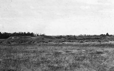
Near by is the huge pit from which the earth was removed and which now contains a large quantity of water. During the hot summer of 1921 it became a favourite spot for undergraduates to bathe without permission, and was commonly known by them as the “Blue Lagoon”.
Note the notice-board: “Bathers will be prosecuted”. Thereby hangs a tale. Mr G. R. C. Foster was walking across the land with Mr. Boggis his agent, when he noticed some clothes on the bank. Naturally he went to see why they were there. To his astonishment he saw a couple bathing. They had not the regulation costume on but were attired in their birthday clothes. Mr. Foster was annoyed and said to Mr. Boggis, “Let’s sit down and keep the bounders in the cold water to cool them down.” After a time the man swam towards them and said, “Are you going to move?” Mr. Foster replied, “Why should I on my own land?” With that the young man went off. I wonder how he felt. After a time Mr. Foster, like the sport he is, said, “Come on, let’s go”, and left them to it.
Later the notice-boards appeared, but some have been pulled down.
Coprolite diggings, near Hauxton Road. “Blue Lagoon” – sign “Bathers will be Prosecuted”.
2019 update: this long pit is now a feature in Trumpington Meadows, which you get to if you cross the footbridge over the M11.
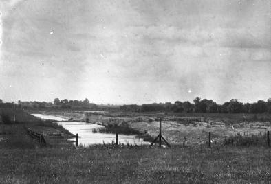
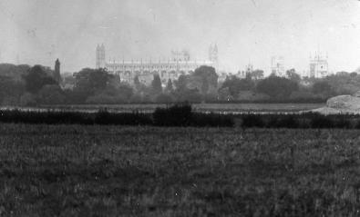
View across coprolite diggings to King’s College.
2019 update: this clear view across to King’s College Chapel is no longer possible from here, as the motorway embankment is in the way.
Other photographs in the Robinson Collection not referred to in the text
U pdate: there are a few additional slides which are in Robinson’s collection but not discussed in the text .
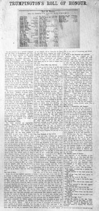
Trumpington Roll of Honour , article reprinted from Cambridge Chronicle , 3 September 1915, with list of men serving in the forces in 1914.
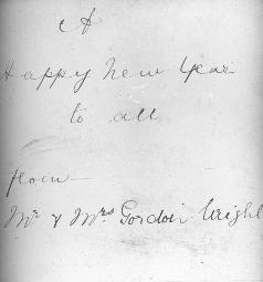
Handwritten card with ‘A Happy New Year to all from Mr & Mrs Gordon Wright’. Charles Gordon Wright was the vicar from 1891- 1903.
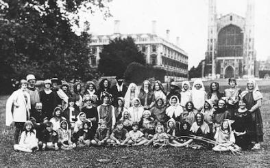
Group of children and adults dressed in Medieval costume outside King’s College Chapel.
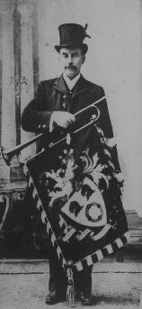
Musician with flag on instrument.
2019 update: this group photograph was clearly taken on the Backs by Kings College chapel, but who are they all and what was the occasion? We have tried to identify the coat of arms in the second photograph, but without success. Might this be Robinson himself in a ceremonial role? A local heraldic expert describes the shield as “two lions’ heads erased in base a garland”.
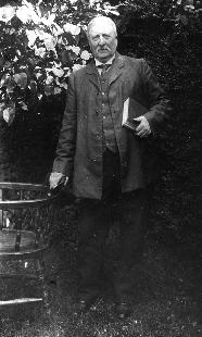
2020 update: Elderly man at North Cottages
Left: Robinson photograph of an e lderly man standing beside a fence , with ladies on the path.
Right: In May 2020, David Chamberlain contacted us with a fuller version of the photograph, showing North Cottages to the left of the scene shown in the Robinson photograph. We had previously thought that the elderly man might be Joe Medlock, who was the last person to live at Dagling End, and was referred to by name in Robinson’s notes.
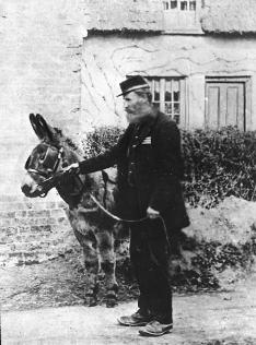
Postman and his donkey. 2019 update: t he postman is probably somewhere in Trumpington, but where and when?
