The Historic Centre of Trumpington
Discover the 1000 Year History of the Village
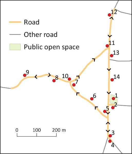
Walk or cycle 1.2 miles/1.9 kms: walk on pavements and footpaths; cycle on roads and dual use paths
This is one of a series of history trails about Trumpington and its links to surrounding villages and Cambridge. We hope that long-established and new residents will find the trails to be a fascinating way to discover more about the history of the area.
The trails have been developed by the Trumpington Residents’ Association and the Trumpington Local History Group, with support from Cambridge City Council. The project is led by Andrew Roberts and Howard Slatter.
Printed copies available free of charge from The Clay Farm Centre and Trumpington Pavilion.
Contact the Local History Group with feedback: admin@trumpingtonlocalhistorygroup.org.
Download a PDF version of the trail or continue with the route …
The 10 trails issued in 2016 start and finish at the green. Anstey Way was constructed in the 1940s and the crescent of shops was added in the 1950s on the site of a recreation ground and cricket pitch. Go to the junction with the High Street.
2. Junction of Anstey Way/High Street
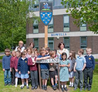
Bidwells Head Office is on the site of Church Farm’s farmyard, built in 1967-68 and extended in the 1970s. Charles Bidwell founded the company in Ely in 1839. In the early 1900s, the land to the right of Bidwells included a wood-yard, cycle shop and village lock-up, replaced by the garage and shops in 1957. Go left along the High Street, passing wrought iron gates which were the entrance to Crossway Nurseries, built after 1925 on one of Church Farm’s fields.
3. Junction of Hauxton Road/Shelford Road
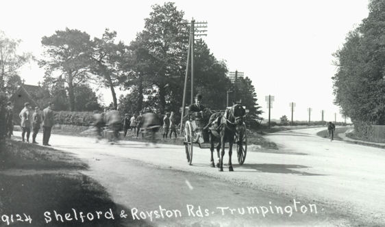
From the 1720s, two turnpike roads merged at the junction and the High Street follows the combined turnpike route into Cambridge (Trail 3). In the early 1900s, this was the edge of the village, with new houses being constructed on the High Street and at the start of Shelford Road (Trail 8). Cross Shelford Road to the cemetery.
The cemetery opened in 1893, before any houses were built on this part of Shelford Road. Sir George Darwin (son of Charles Darwin) and Maud du Puy and their daughter Gwen Raverat, author of Period Piece , are buried here (walk along the path lined with yew trees; their grave is marked by a flat stone three rows to the left beyond the last tree on the left). Cross Hauxton Road (Trails 3 and 7) and turn right. Go past the toll house, with windows which gave good views along the road, built 1811, and the weighbridge house to its right, built 1863, to the village sign.
5. Trumpington Village Sign
The sign was unveiled in 2010 and shows Sir Roger de Trumpington on horseback, below which is a shield based on the details on the brass in the Church. Go left along Maris Lane past the Bidwells building.
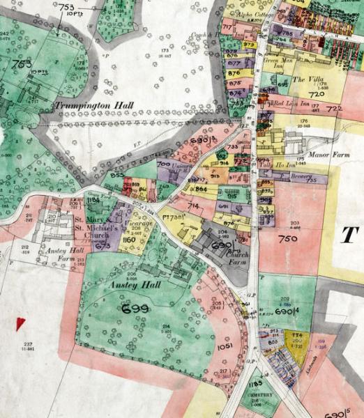
6. Maris Lane and Anstey Hall
Church Farm was on the right (there is an old farm sign on the wall to the left of the Bidwells access road). The first buildings on the other side of Maris Lane are part of Anstey Hall. Further on the left, the Coachman’s House was built in 1865, with a roundel showing ‘CFF’ (Charles Finch Foster, owner of the hall). The house on the right is Maris House (Church House), the farm house of Church Farm, built around 1800 by the Maris family who farmed here from the 1770s-1867. Anstey Hall itself is in the grounds on the left. This was built by Anthony Thompson around 1670, on the site of a Medieval manor. The hall was owned by the Thompson family from 1637-1748, the Anstey family from 1748-1838 and the Foster family from 1838-1941, and extended in the late 1800s. Go to the junction.
7. Junction of Maris Lane/Grantchester Road
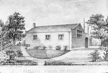
The building opposite opened in 1843 as a National School. Known as the Church School, it continued until 1950 when pupils transferred to Fawcett School. The Schoolmaster’s House to its right was built in 1858, designed by William Butterfield. Go left to the Parish Church.
At the entrance to the churchyard, the building by the gateway is The Bakehouse, renovated by the church in 2010. The brick-built vicarage to the rear was built around 1733 and has been a private house since 2009. The dwellings opposite include Number 18, set back from the road, dated 1654, and timber-framed cottages to its left, dated late 1600s to early 1700s. The current church building dates from 1200-1330: the interior is open during the day (Feature D). Continue on the churchyard path and then along Grantchester Road.
9. Anstey Hall Farm
Anstey Hall Farm is to the left. The farm house dates from the 1600s. Its outbuildings included a large weather boarded threshing barn and a pyramidal dovecote, converted into homes in 2016. Trumpington Hall is behind the trees to the right, purchased by Sir Francis Pemberton in 1675 and rebuilt in 1715-35. Stop at the right-hand bend: the road continues to the River Cam and Byron’s Pool, with the Country Park on the left (Trails 6 and 9). To continue on this trail, turn back and fork left into Church Lane.
10. Church Lane
The ‘Old House’ on the right dates from the late 1500s, with narrow red bricks and crow- stepped gables. The Lord Byron pub on the left dates from the mid-1800s (called The Unicorn until 2012). Continue alongside the boundary wall of Trumpington Hall to the junction.
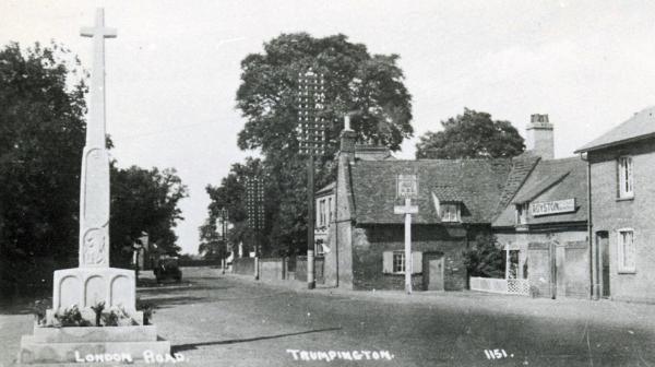
11. Cross Hill and the War Memorial
The War Memorial was unveiled in 1921 on the site of the earlier village cross (Feature A, C). The main driveway to Trumpington Hall is through the gates. The area to the right of the gates was the site of the village stocks and blacksmith’s. The fields both sides of the drive had been incorporated into Trumpington Hall estate by 1800; before that, they may have been part of the village green, with one area known as Camping Close (‘camping’ was an early form of football). The blacksmith’s moved to the other side of Church Lane in the 1850s: the low flint wall is the only evidence of the smithy, as Bidwells was built on the site in 1986. The Red Lion pub and Manor Farm were to the left and right on the other side of the High Street, lost in the 1960s-70s. Continue along the High Street.
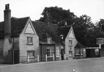
There are two historic pubs either side of the turnpike road. The Coach & Horses was built in the late 1600s and the Green Man in the 1400s as a timber-framed hall-house. Go across the High Street: St Mary’s House on the corner of Alpha Terrace is on the site of a boarding school run by James Cuming and his son Charles from the 1790s-1840s (Trail 4). Return along the east side of the High Street. The road surface has gradually built up, so that it is now higher than the ground floors of the pubs and houses. Look back at the Green Man and its sturdy chimney which would have been subject to the hearth tax when this was levied in 1664. In the early 1900s, it was well-known for its shaded tea garden, complete with tree-house. Continue past red- brick houses opposite dating from the 1600s, to the corner of Beverley Way.
Manor Farm was on this corner until it was demolished in 1968-71. Its fields extended east from the village, crossed by a farm track, the line of which is followed by Beverley Way, Paget Road and the path across Clay Farm to the railway (Feature B). The Village Hall opposite opened in 1908. Designed by Walter H. Brierley, it has a corner stone inscribed ‘PFSP’ (Patience Frances Sophia Pemberton) and the date over the entrance. The notice-board was erected in 2008 to commemorate its centenary. The original building consisted of the current main hall, with no internal toilets. Cross Beverley Way, continue past Hudson’s Ale House (called The Tally Ho! until 2015) and stop opposite Whitlocks.
14. Whitlocks
In 1728, George Whitelocke left his house as a legacy to the poor of the village. The house and malting were reconstructed in 1819 and again in the late 1800s when the area was known as ‘Whitelock’s Yard’ or ‘Workhouse Yard’. The land was sold to the Council in 1963 and it was rebuilt in 1968 and again in 2006. The house to its left is called The Red House, built of red brick in the early 19th century. Return to Anstey Way.
A. Early Development of the Village
Trumpington village developed around the junction of one route from the south towards Cambridge and another from the southeast to the ford to Grantchester. The earliest evidence of the village is a group of Saxon houses and graves, excavated in 2011 just south of the church. By 1000 AD, the local parishes and villages were well established. In the Domesday Book, 1086, Trumpington had 37 households, 4 manors and a mill. The focus was the church and the nearby manor houses, one of which was owned by the Trumpington family whose memorial was placed in the church in the 1320s. By the late 1400s, the village had a green bounded by a triangle of roads with a village cross at its northern apex and another open area to the west of the cross.
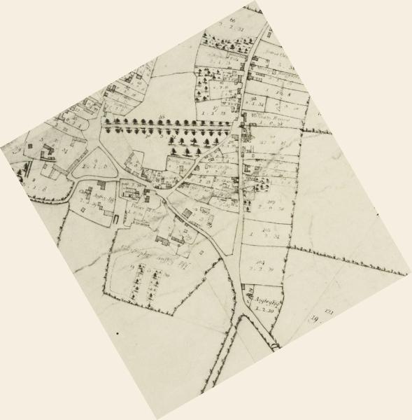
B. The Village after 1800
The parish was enclosed in 1809, by Act of Parliament. The manors had already consolidated into two estates (the Pembertons’ at Trumpington Hall and the Ansteys’ at Anstey Hall) and these were allocated most of the land. In the early 1900s, the heart of the village had three working farms (Manor Farm, Church Farm and Anstey Hall Farm) and agricultural services such as a blacksmith. Houses had been built on the village green and either side of the High Street but the village was still tightly compact and surrounded by farmland. It was only in the mid-1900s that housing spread over the farm fields east of the High Street and east of the road to Cambridge, while the fields to the west and southwest were still retained for farming.
C. Cross Hill and War Memorial
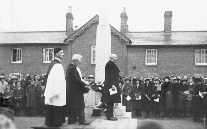
The War Memorial was unveiled on Cross Hill on 11 December 1921. Sculpted by Eric Gill, the Portland stone monument is 19 feet high. It records the names of Trumpington men who lost their lives in both world wars and incorporates four sculptured panels: St Mary with the baby Jesus and the cradle (west); St George slaying the dragon (north); St Michael slaying the dragon (east); the figure of a weary soldier, walking westwards towards the setting sun (south).
The Memorial stands on the site of an earlier village cross, the base of which was discovered when the Memorial was erected and is now in the church. The base is inscribed ‘Orate pro animab[us] Joh[ann]is Stokton et Agnetis uxoris ei[us]’ [Pray for the souls of John Stokton and of Agnes his wife] and dates from around 1480. It is thought that John and Agnes Stokton lived in a house in Church Lane (near the area now occupied by The Lord Byron pub) and that John Stokton was a farmer.
D. Trumpington Parish Church
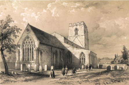
The Parish Church was mainly built 1200-1330, renovated by William Butterfield in 1876, when the original Barnack stone was partly refaced with Bath stone. Highlights of the interior include the base of the village cross (stop 11); a monument to the Trumpington family with a memorial brass of a knight, 1320s; wall memorials; and stained glass. In the churchyard, go from the north porch around the tower to the south side. There are headstones to the Maris family near the south porch and memorials to the Pemberton and Foster families to the right. Continue to the south of the chancel, where there is the grave of Henry Fawcett, Postmaster General, died 1884, and a headstone further left to William Stacey, died 1729. There is a restored tomb canopy with coffin lid on the chancel wall, possibly to a member of the Trumpington family. Return to the north porch. The base of the churchyard cross is to the right, with a headstone dated 1719 to its left.
Additional information
trumpingtonlocalhistorygroup.org
trumpingtonresidentsassociation.org
For information about Trumpington Church, see trumpington.church and The Trumpet.
Second edition, © TLHG and TRA, September 2016.