Addenbrooke’s and Queen Edith’s
Medical and Research Centre in an Historic Landscape
Walk or cycle approximately 6 miles/9.7 kms: walk on pavements and footpaths; cycle on roads and dual use paths
This is one of a series of history trails about Trumpington and its links to surrounding villages and Cambridge. We hope that long-established and new residents will find the trails to be a fascinating way to discover more about the history of the area.
The trails have been developed by the Trumpington Residents’ Association and the Trumpington Local History Group, with support from Cambridge City Council. The project is led by Andrew Roberts and Howard Slatter. Thanks to Hilary Ritchie, Addenbrooke’s Hospital Archivist, and Damian Hebron, Addenbrooke’s Art Coordinator.
Printed copies available free of charge from The Clay Farm Centre and Trumpington Pavilion.
Contact the Local History Group with feedback: admin@trumpingtonlocalhistorygroup.org .
Download a PDF version of the trail or continue with the route …
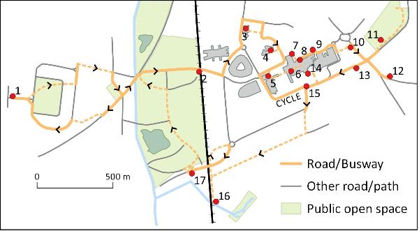
1. Start at the green by the shops, Anstey Way
NO PHOTOGRAPHY ON HOSPITAL SITE
2. Busway railway bridge
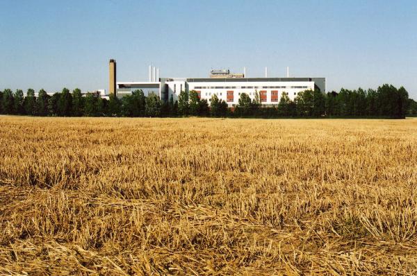
The London to Cambridge railway line opened in 1845. The Medical Research Council’s Laboratory of Molecular Biology (LMB) building on the left opened in 2013. The Cambridge Biomedical Campus (CBC) is expanding across this area, including a public space and AstraZeneca and Papworth Hospital, constructed since 2015. Continue to the road, named after LMB scientist Francis Crick. Go left to the roundabout, turn left, go past the grey building then on the road to the right, named after Miss Mima Puddicombe, Matron, 1958-70.
3. Cancer Research Institute
Go a short distance along the road then turn right and right again to the front of the Cancer Research Institute’s Li Ka Shing Centre, opened by the Queen in 2007. The bronze Taichi Arch – Gate of Health , by the Chinese sculptor Ju Ming, is in the garden outside the entrance. Turn around and take the path to the right, past the multi-storey car park and a new university research centre and continue to the road.
4. Frank Lee Centre and Pemberton House
On the right, the Frank Lee staff sports centre and Pemberton House are on land given by the Pemberton Trustees of Trumpington Hall. Sir Francis Pemberton succeeded Sir Frank Lee as Chairman of the Development Trust which was responsible for the projects. The Centre opened in 1972. Nearby Pemberton House provides accommodation for relatives of patients: there is a stone sculpture to Sir Francis Pemberton in the foreground. Go ahead on Keith Day Road, bear right and stop at the Addenbrooke’s Treatment Centre on the left. The site to the right is The Forum development, including a private hospital, hotel, learning centre and conference centre.
5. Addenbrooke’s Treatment Centre (ATC)
The Addenbrooke’s Treatment Centre opened in 2008, with additional wards, theatres, research and clinical facilities. Go into the foyer, where there is a suspended sculpture, Asklepian , by Ivan Black, 2008, symbolising the Rod of Asclepius , the serpent-entwined rod wielded by the Greek god of healing and medicine. There is a plaque about the sculpture near the entrance.
Cyclists should continue along Keith Day Road, turn left into Robinson Way, follow this to the roundabout at the Hills Road entrance where there is cycle parking, then walk to the main entrance to rejoin the route at stop 6 or 7.
6. Addenbrooke’s Art Walk
From the ATC foyer, take the corridor to the left which includes art works and history panels. Continue in the corridor beyond the shops to a plaque on the right commemorating the opening of the Art Walk by Sir Roy Calne in 2002. There is a display on the left of An Informal Panorama by Quentin Blake, commemorating the 800th anniversary of the university in 2009, and Mosaics by Jim Anderson in the lift foyer to the right. Return to the shop area and turn right to the main entrance where there is a plaque above the reception desk to Cambridge sculptor David Kindersley. Go out of the main doors, turn left.
7. Hospital Chimney and Dialysis Centre
Follow the footpath a short distance. The hospital chimney is visible ahead: this was built in the late 1960s in just 12 days and nights, by the continuous pouring of cement into a mould which was slowly moved upwards. Go to the far corner by a conifer tree where there is Anchor Sculpture by Christine Fox, 1999, in front of the Dialysis Centre. Go back to the main entrance.
8. Commemorating Dr John Addenbrooke
There is a Blue Plaque to the left of the entrance to Dr John Addenbrooke. Walk away from the entrance under the bridge and straight ahead. To the right of the door to Pathology, there is a wall sculpture with four bronze figures, Family Group , by Daphne Hardy Henrion, purchased in 1994. Stop at the junction of the road to A&E.
9. New Addenbrooke’s from 1960s
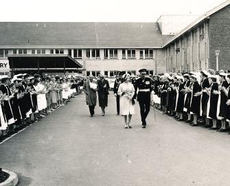
The building across the road to the right was the Laboratory of Molecular Biology from 1962 until the move in 2013. The building to its left is the School of Clinical Medicine, whose first students were admitted in 1976. The sculpture on the A&E wall on this side of the road is Futurian 1989 , by Michael Kenny. Go up the slope ahead to Outpatients where there is a plaque to the left of the entrance doors commemorating the opening of the new hospital by The Queen on 28 May 1962. Go away from Outpatients, bear right and cross the road towards the bus station to leave the hospital site. Continue to Hills Road.
10. Hills Road and old parish boundary
Hills Road marks the boundary between the historic parishes of Trumpington and Cherry Hinton. In 1709, William Wort left money to rebuild the road and it was part of the turnpike from Cambridge to Haverhill from 1765 to 1870. Go right, cross at the pedestrian lights and go down Nightingale Avenue to the nearby park.
11. Nightingale Park and Community Garden
This area was developed in the 1950s, on land owned by St Thomas’ Hospital. The road and park are named after Florence Nightingale, whose nursing school was at St Thomas’. Go through the park to a Community Garden in the far corner. Return to Hills Road and go left to the junction, named ‘Red Cross’ on maps in the early 1800s, possibly the site of a Medieval cross? The road straight ahead was the turnpike to Haverhill. Turn left and continue to the post box.
12. Wort’s Causeway and the Roman Road
The building opposite is the Strangeways Research Laboratory, early 20th century, now housing researchers focussing on genetics. William Wort paid for the construction of the causeway, completed in 1733. To extend the trail, follow the road to Beechwood nature reserve and a 16 km path along the line of the Roman road from Cambridge towards Colchester, with links to Wandlebury. To continue the trail, return to the pedestrian lights on Hills Road and cross to the lane opposite.
13. Red Cross Lane and Red Cross Farm
The lane is marked as a ‘Private Road’ on the Trumpington inclosure map of 1804. Soon after, Red Cross Farm was built a short distance along the lane on the left. In the 1900s, there was a farm track from here to Trumpington. Continue past the Bell School along the lane to the mini roundabout. The Forvie site to the left included a large house in wooded grounds until it was developed for research institutes.
14. Addenbrooke’s Jubilee Garden
Turn right at the roundabout past Wards R2-4 to the Jubilee Garden, opened in 2002 for the Queen’s Golden Jubilee. It includes a central sculpture by Cambridge’s Cardoza Kindersley workshop, made of stone from Cambridge’s Rattee and Kett stoneyard. Return to the roundabout and go right to the junction.
15. Robinson Way and The Rosie
The Rosie maternity hospital is further on the right, named after the wife of Sir David Robinson, opened in 1983 and extended in 2012. Cross the road at the lights, into Dame Mary Archer Way. Follow the footpath/cycle path beside the road and keep straight ahead where the road goes right, on the cycle path around the perimeter of CBC. Continue to the railway line and go left to the bridge over Hobson’s Brook.
16. DNA and the National Cycle Network
The sculpture commemorates Crick and Watson’s work on DNA and the cycle network. Nine Wells nature reserve is to the left (Trail 5). The path continues to Great Shelford (Trail 8) but turn back, go ahead under the road bridge and follow the path over the bridge.
17. Addenbrooke’s Road and Hobson’s Park
Addenbrooke’s Road opened in 2010. Take the path to the right, down the slope into Hobson’s Park, opened in 2016-17 (Trail 5). Follow the path to the right of the lake. The white and orange poles mark a gas pipeline, on the route of the track from Church Farm to Red Cross Farm. Continue with the allotments on your left. Go left to the Busway junction, cross the Busway and turn left and go past Hobson Square. Before the busway stop, take the path to the right signed ‘Trumpington’, to return to Anstey Way.
Old and New Addenbrooke’s
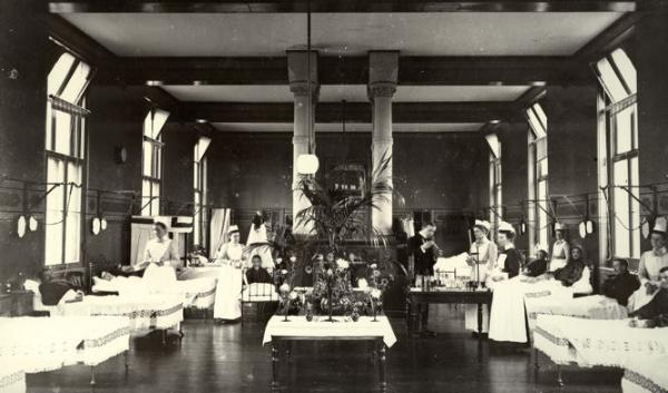
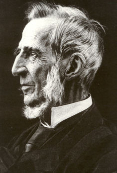
Addenbrooke’s Hospital is named after Dr John Addenbrooke (died 1719), who in his will left over £4000 to found a hospital in Cambridge. The hospital for the poor eventually opened in Trumpington Street in 1766 with 20 beds in two wards. It expanded in the mid 1800s under leading doctors such as Sir George Edward Paget and Sir George Murray Humphry, who developed medical education in Cambridge.
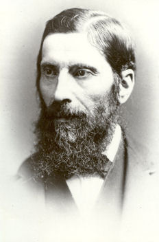
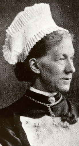
The quality of nursing was transformed when Alice Fisher was appointed Matron in 1877, greatly influenced by Florence Nightingale. Nearly 80 years later in 1958, Mima Puddicombe was appointed as the last Matron on the old site.
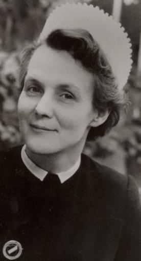
In the 1950s, work began on the new hospital on the Hills Road site. The first ward and departments opened in 1961, with Miss Puddicombe as Matron until 1970. Both sites were used until 1984, when the Trumpington Street hospital closed.
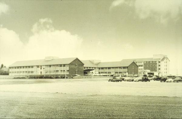
The role of the Hills Road site has developed greatly since the 1960s. The Cambridge maternity hospital moved here from Mill Road in 1983, named The Rosie after Rosie Emily Robinson (née Tricker), whose son Sir David Robinson gave £3m towards the project.
The overall site is now known as the Cambridge Biomedical Campus (CBC) and includes world famous University of Cambridge and medical research institutes such as the Laboratory of Molecular Biology (LMB). Established by the Medical Research Council in 1947, the Laboratory has won 9 Nobel Prizes, shared by 13 scientists. Four LBM scientists were awarded Nobel Prizes in 1962: Max Perutz and John Kendrick for the structures of globular proteins; and James Watson and Francis Crick for the structure of DNA.
Up to the late 2000s, the area between the railway line and Robinson Way was farmland. This is now crossed by Addenbrooke’s Road and the Busway, with LMB to the north of the Busway bridge and major new buildings for AstraZeneca and Papworth Hospital.
Addenbrooke’s Archaeology
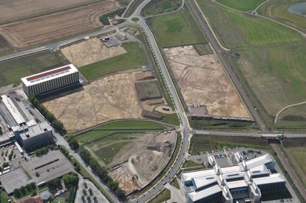
There have been extensive excavations in advance of the development of the Biomedical Campus. The photograph shows the Papworth and AstraZeneca sites with archaeological work underway, with features visible in the subsoil. There was a settlement here in the Bronze Age, before 1000BC, including a triple-ditched enclosure later cut by the railway line. There was extensive agricultural use in the late Iron Age and into the Roman period, when there was a settlement in the northern part of the area, specialising in pottery production. The land was crossed by an east-west road, perhaps linking with the more substantial Roman road from Cambridge to Colchester, which was on a similar alignment to Hills Road and Wort’s Causeway. There was further settlement in the early Saxon period but this failed to develop into a village, with the land continuing to be farmed.
Additional information
trumpingtonlocalhistorygroup.org
trumpingtonresidentsassociation.org
Addenbrooke’s Arts: http://www.cuh.org.uk/services/non-clinical-services/addenbrookes-arts
© TLHG and TRA, September 2016, updated April 2022.