Trumpington and Cambridge Connections
Explore the Route between Trumpington and Cambridge
Walk or cycle, approximately 6 miles/9.7 kms: walk on pavements and footpaths; cycle on roads and dual use paths.
This is one of a series of history trails about Trumpington and its links to surrounding villages and Cambridge. We hope that long-established and new residents will find the trails to be a fascinating way to discover more about the history of the area.
The trails have been developed by the Trumpington Residents’ Association and the Trumpington Local History Group, with support from Cambridge City Council. The project is led by Andrew Roberts and Howard Slatter.
Printed copies available free of charge from The Clay Farm Centre and Trumpington Pavilion.
Contact the Local History Group with feedback: admin@trumpingtonlocalhistorygroup.org.
Download a PDF version of the trail or continue with the route …
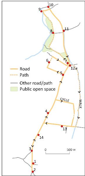
Go from the green to the High Street, turn left and go to the junction with Shelford Road.
2. Turnpikes to Cambridge
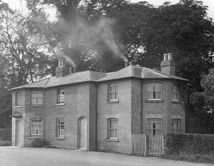
The High Street follows the route from the south to Cambridge. From the 1720s, two turnpike roads merged at this junction: from Barkway (straight ahead) and Great Chesterford (from the left) (Feature A). The tollhouse on the other side of the High Street was built in 1811, with a weighbridge added to its right in 1863. Return to the pedestrian lights, cross, turn right, continue along the High Street to the War Memorial.
3. War Memorial and Cross Hill
The War Memorial was dedicated in 1921 at Cross Hill, the same location as the Medieval village cross (Trail 1). The surroundings were renovated in 2014. Through the gates to the left, there is a lodge and the driveway to Trumpington Hall. Continue along the High Street (Trail 1) and its continuation, Trumpington Road. Go a short distance beyond the Long Road junction and stop opposite the school sign on the right.
4. Trumpington Road
The building across the road is Leighton House (the Perse Preparatory School), built in 1866-69 for Cambridge philanthropist and retailer Robert Sayle (his store is now the Cambridge John Lewis’s). The grounds were called Gibbet Hill, the site of a gallows until the late 1700s. The land that side of the road was part of Trinity Farm until it was developed for housing and the local roads are named after Trinity College fellows. The fields this side of the road are part of River Farm. When the parish was enclosed in 1809, the tree belt was already well established. Continue along the former turnpike route to the junction with Latham Road on the left.
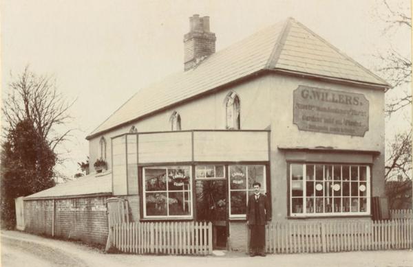
St Faith’s School on the far side of Trumpington Road moved here in 1892. The school gates and railings were designed by Matthew Lane Sanderson in 2006 and 2011. The pink house at this corner was part of Willers’ Nursery until the 1930s (Feature B). Turn into Latham Road, named after Reverend Henry Latham, Master of Trinity Hall, who built Southacre House on the right in 1880, demolished in 1989 (Feature B). Continue past houses in Queen Anne Revival (numbers 1, 5) and Arts & Crafts (numbers 3, 9, 11, 15) styles. River Farm is at the far end of the road, but before this, turn right by number 16 into Latham Close and go to the playing field.
6. Stephen Perse Playing Field (Dam Hill)
The trees beyond the field mark a slope down to the river. There was a large Iron Age, Roman and Anglo-Saxon cemetery here, with finds (now in the Fitzwilliam Museum) discovered in 1709 in the area between the grass pitch and the garden fences on the right. Continue on the path and go right along Chaucer Road, named after Geoffrey Chaucer whose Reeve’s Tale was set in Trumpington (Feature B). Number 15 was used by the University Air Squadron during World War II, when drill parades were held in the road. The Medical Research Council Cognition and Brain Sciences unit moved here in 1953. Go left at the end of Chaucer Road, to the junction.
The first of the Trinity Hall milestones, dated 1728, is beside the Stone Bridge across Vicar’s Brook (Feature A). Turn onto the path to the left and look back at the rear of the exceptionally long milestone. Continue alongside Vicar’s Brook, take the fork to the right along the edge of the common, with Leys School playing fields and theatre (Great Hall, opened 2014) to the right. Go across Fen Causeway at the pedestrian lights.
8. Coe Fen
Continue along the edge of Coe Fen as far as the buttressed wall on the right. This is the rear wall of Peterhouse, incorporating a watergate, with college buildings and the Fitzwilliam Museum behind. The grounds inside the wall were the smallest Deer Park in the country in the 1800s. Continue to the road and on to the mill pond.
9. Mill Pond and King’s Ditch
This was the head of river navigation, with quays and mills in use until the 1930s. A mill race and foundations are to the left. The King’s Ditch joined the river where the lower punts are based. Turn right up Mill Lane along the line of the King’s Ditch to the junction with Trumpington Street, then left to the corner of Silver Street.
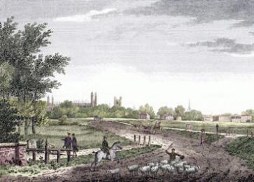
10. Trumpington Gate, Trumpington Street
St Botolph’s Church opposite is dedicated to the patron saint of travellers. Trumpington Gate crossed the road between here and Pembroke Street (Feature D). Turn around and continue on the left side of Trumpington Street, crossing Pembroke Street. Go past Pembroke College on the left, and Little St Mary’s Church, built 1352, and Peterhouse on the right. The runnels both sides of the road bring water from Hobson’s Conduit. Continue past the Fitzwilliam Museum on the right and the former Addenbrooke’s Hospital (now the Judge Business School and Brown’s Restaurant) on the left. Continue to Lensfield Road, cross and stop on the far side.
11. Hobson’s Conduit Monument
The monument is fed by water from Hobson’s Conduit (Feature C). It provided water in the market place from 1614 until moved here in 1856. Continue along Trumpington Road, with Brookside on the left, including number 18, the home of Henry and Millicent Fawcett from 1874- 84 (Blue Plaque). Continue past the Botanic Garden which was at a site in Downing Street until 1846. The wrought iron gates beyond the current entrance were brought here from the original site in 1909. Continue to Brooklands Avenue, crossing it to the Stone Bridge, where the walking and cycling routes divide.
12. Hobson’s Brook (walkers)
For the walking route, go a short distance to the left along Brooklands Avenue then turn right alongside Hobson’s Brook and look out for kingfishers (Feature C). On the right, the path passes allotments, a nature reserve and paddocks; on the left, a World War II pillbox and a massive bunker (built in the 1950s for the regional government in the event of nuclear war). Continue to Long Road and turn right.
12. Barrow Road milestone (cyclists)
For the cycling route, continue along Trumpington Road to Barrow Road. At the junction, turn back 10 m to the green utility cabinet. The first of the Great Chesterford milestones is about 1 m to the left, hidden in the undergrowth near the fence. It is on its back, after being damaged by an Air Force lorry in 1922. Go along Barrow Road, bear right, continue straight ahead on a path to Rutherford Road named after Trinity College fellow, Lord Rutherford, then right into Long Road.
13. Clay Farm
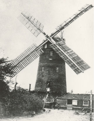
Cross at the lights and continue along Long Road. The Clay Farm neighbourhood to the left is on land that was farmed until 2007, developed for housing from 2011 (Trail 5). Clay Farm House, built in the early 1800s, is further on the left, down the side road to Hudson Close. Go past Mill Cottages on the right: there was a tower windmill to the rear in the 1800s, remembered in the name of the house at the junction, Mill House. Turn left and go along the High Street.
The second Trinity Hall milestone is beside the road, erected in 1729. In the late 1700s, travellers from Cambridge would have seen the first properties in Trumpington in the near distance, including the Green Man and Coach & Horses public houses either side of the road. Continue along the High Street to return to Anstey Way.
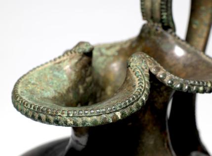
A. Trumpington Turnpikes
Trumpington has been on the route from the south to the Cambridge area for thousands of years. One important road ran from London to Barkway then Cambridge and another from London to Great Chesterford then Cambridge. The first stagecoach service from London was introduced in 1653. The boundary between Trumpington parish and Cambridge was marked by a stream and a ford, Trumpington Ford, replaced by a bridge by the late 1600s.
Two turnpike roads to Cambridge were constructed in the 1720s, merging on the southern side of Trumpington village. Trinity Hall set up a series of milestones along the Cambridge-Barkway turnpike, starting at a marker on Great St Mary’s Church and still visible through Trumpington. There was another series of less conspicuous milestones along the Great Chesterford turnpike.
B. From Farming to Housing
In the Medieval period, farming dominated the economy. Most of Trumpington parish was open fields, including Cambridge Field and Moor Field west and east of the road to Cambridge.
The parish was enclosed in 1809 and a number of large farms were developed. As Trumpington village grew in size, the parish remained predominantly agricultural. The fields around Cambridge were also enclosed and the town expanded to the south. From 1882, university fellows were allowed to marry, creating a new demand for family homes. Chaucer Road and Latham Road were developed in the north of the parish, followed by the land between Trumpington Road, Long Road and Brooklands Avenue. During the 20th century, much of the farmland close to the village was also used for housing, the latest stage of which was the building on Clay Farm from 2011.
C. Vicar’s Brook and Hobson’s Conduit
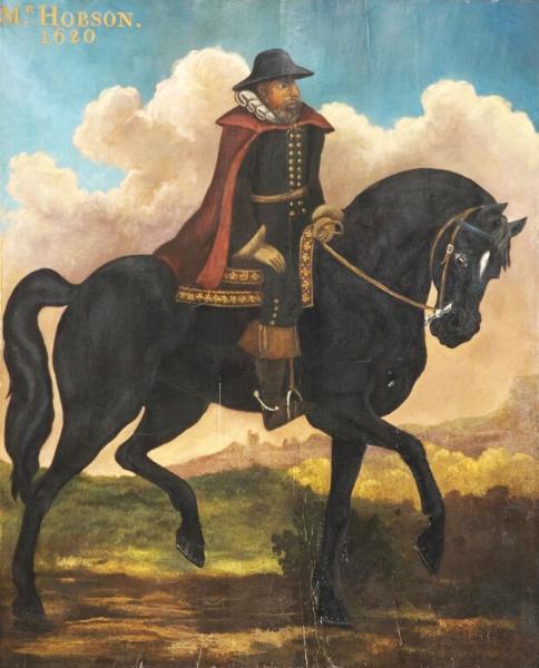
A small stream, the Vicar’s Brook, runs in the valley to the east of Trumpington village, rising at Nine Wells to the south of Addenbrooke’s Hospital and flowing into the River Cam at Coe Fen. In the late 1500s, a plan was developed to use the stream as a source of fresh water for Cambridge. Thomas Chaplin gave permission for the work through his manor in Trumpington and the scheme was completed by 1610. It involved building a conduit to carry water from the stream into town, including runnels along Trumpington Street, a fountain on Market Hill and a series of underground channels to supply some of the colleges. When Thomas Hobson, a Cambridge carrier, died in 1631, he left money towards the scheme and it became known as Hobson’s Conduit. He is infamous for giving clients no choice when he rented out horses, hence the phrase Hobson’s Choice.
D. Trumpington Gate, Medieval Cambridge
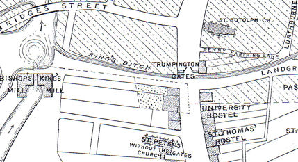
The Roman settlement of Cambridge was to the north of the river. By the Norman Conquest, the focus of the town had moved south of the river and extended either side of the road from London. There was a protective ditch around the town, the King’s Ditch, the line of which is followed by Mill Lane and Pembroke Street. Travellers and traders crossed the ditch into town at Trumpington Gate, near the junction of Trumpington Street and Pembroke Street. The gate had disappeared by the time Richard Lyne drew a map of Cambridge in 1574, when the road into town was named Trumpington Streate . The area outside the Gate developed as a suburb, including St Peter’s Church, a leper hospital and hostels which became the first colleges.
There were close connections between the town and the nearby village of Trumpington, including the use of Cambridge Market. One of the Medieval manorial lords of Trumpington, the de Cailly family, were also traders in Cambridge.
Additional information
trumpingtonlocalhistorygroup.org
trumpingtonresidentsassociation.org
© TLHG and TRA, September 2016.