South of the Village Centre
Changes on the South Side of Trumpington Since the 19th Century
Walk or cycle 3.6 miles/5.8 kms: walk on pavements and footpaths; cycle on roads and dual use paths
This is one of a series of history trails about Trumpington and its links to surrounding villages and Cambridge. We hope that long-established and new residents will find the trails to be a fascinating way to discover more about the history of the area.
The trails have been developed by the Trumpington Residents’ Association and the Trumpington Local History Group, with support from Cambridge City Council. The project is led by Andrew Roberts and Howard Slatter.
Printed copies available free of charge from The Clay Farm Centre and Trumpington Pavilion.
Contact the Local History Group with feedback: admin@trumpingtonlocalhistorygroup.org.
Download a PDF version of the trail or continue with the route …
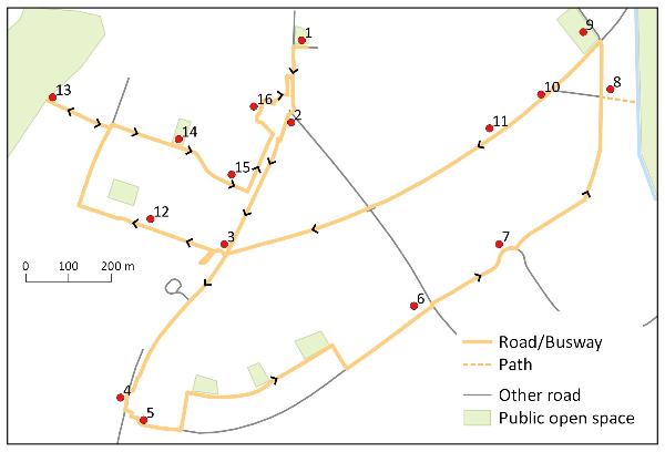
1. Start at the green by the shops, Anstey Way
2. Hauxton Road
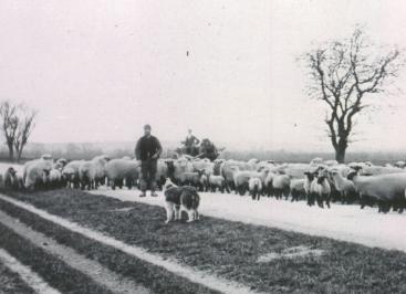
The land to the left was allocated to the Parish Church when Trumpington was enclosed in 1809. The cemetery opened in 1893 when the road from here to Hauxton Mill was still through countryside (cover photograph). Continue along Hauxton Road. The cul-de-sac of single-storey homes, Allen Court, was built for retired clergy in 1964, with breeze blocks used as garden walls. The houses on the left date from about 1930, when there were allotments to the rear. Cross to the other side of the road at the traffic lights and continue along Hauxton Road to the bridge.
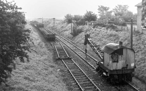
3. Hauxton Road railway bridge
The bridge was constructed as part of the Cambridge-Bedford railway, opened in 1862, in the cutting now used by the Busway, opened in 2011. The final part of the cutting to the right has been filled in: the line ran across Anstey Hall Farm to a river bridge. Continue to the road into the Trumpington Park & Ride site which opened in 2001. Cross this junction, go along Hauxton Road and stop at the milestone.
4. Turnpike Milestone and PoW Camp
The milestone was erected by Trinity Hall in 1729, the third on the Cambridge-Barkway turnpike (Trails 2, 7). The land to the right was part of Anstey Hall Farm and then the Plant Breeding Institute. It is crossed by the M11, opened in 1979 (Trail 7). Looking to the right towards the M11, the 1940s PoW Camp was to the left of the path/road which goes to the right (Feature C). Cross Hauxton Road at the junction, to the start of Addenbrooke’s Road.
5. Addenbrooke’s Road and Glebe Farm
Addenbrooke’s Road, opened in 2010, creating a new edge to Cambridge. The land on the left was farmed until 2010, then developed for housing by Countryside Properties, with the first homes completed in 2012. This was Vicarage Farm, later Glebe Farm, allocated to the Church on enclosure in 1809. Glebe Farm was a dairy farm until the mid 1970s when it became an arable farm with cereals, rape and beans. Take the first left and go along Beech Drive to the green space, turn right and continue past two other green spaces. Turn right to return to Addenbrooke’s Road and continue left to Shelford Road.
This junction was completed in 2010, after the demolition of one house on this side of the road and two semi-detached houses on the other side. Shelford Road is on the line of the Cambridge- Great Chesterford turnpike (Trail 8). Apart from the farm, there were no houses along the road to Great Shelford until the early 1900s. Continue across the junction and go to the roundabout.
7. Clay Farm and the Showground
Most of the land this side of Shelford Road was allocated to the Pemberton family on enclosure in 1809. This part of Clay Farm was known as the Showground, as the Royal Show was held here (Feature D). It was a large arable field until 2007, when work started on Addenbrooke’s Road. The first homes in Countryside’s Abode development were completed in 2012. Addenbrooke’s Road goes right (Trail 8), but follow Hobson Avenue straight ahead, completed in 2013. The lime trees were planted in 2011, when they were 20 year old specimens.
8. Community Garden and Hobson’s Park
Continue past the new primary school on the left to a crossing point where a Community Garden is being developed. Go right to Hobson’s Brook, along the line of an old farm track which started in the village (Trail 3, 10). This part of Hobson’s Park opened in 2016-17 (Trail 5). Return to Hobson Avenue and go right to the Busway and Hobson Square.
9. Hobson Square and Clay Farm Centre
Hobson Square and the Clay Farm Centre open from 2016-17, with the ‘Bronze House’ sculpture as the centrepiece of the square (Trail 4, 5). The Centre has a library, hall, community rooms, café and health centre. Continue left along the Busway path, with the Virido development to the right of the path, including high-spec sustainable homes. The tree belt on the left was planted alongside the former railway line in the 1980s.
The Busway opened in 2011, following the Cambridge-Bedford railway route from Cambridge Station to Trumpington Park & Ride site. There is a time capsule buried in the pavement at the bus stop, marked by a ‘green man’. Continue along the Busway path.
11. Railway/Busway cutting
The area to the right is a Community Orchard and Foster Road Allotments (Trail 5). The cutting dates from the original railway, reused 150 years later for the Busway. After the railway track was removed, the cutting became a nature reserve, with an open stream to the right (now enclosed). There is also a buried high-pressure gas main and a buried pipe bringing water from the river for use by the farm. The stream and services were a challenge when the Busway was constructed, with the beams forming the track being laid over protective slabs. Go under the old railway bridges (carrying Shelford Road and Hauxton Road) and follow the path up the slope, turn sharp right and cross the road. Go on the path along the perimeter of the Park & Ride site.
12. Trumpington Meadows
The homes to the right were the first phase of Trumpington Meadows developed by Grosvenor and Barratt Homes, completed from 2012. Go beyond the John Lewis building past a play area on the right to Osprey Drive. Trumpington Meadows Primary School is on the left, opened in 2013, with a local centre and shops being built straight ahead. Go right along Osprey Drive, with a view to the tower of Trumpington Church. Osprey, Consort, Charger and other local street names are derived from crops developed by PBI. Turn left into Charger Road, to the Country Park.
13. Trumpington Meadows Country Park
The Country Park opened in 2015, with paths giving access to Byron’s Pool, the riverside and Grantchester (Trail 6). Return to Osprey Drive and continue straight ahead along Consort Avenue to the green space and play area.
14. Anstey Hall
Anstey Hall is to the left through the trees, with the current house dating from about 1670, on the site of a Medieval manor (Trails 1, 6). Nearly all the land this side of Hauxton Road, from here as far as Hauxton Mill, was allocated to Christopher Anstey on enclosure in 1809, forming Anstey Hall Farm. Continue along Consort Avenue.
15. Plant Breeding Institute (PBI)
The PBI had glasshouses, workshops, etc., across the site, with its headquarters building near Hauxton Road (Feature B). A golden brick has been built into the wall of 88 properties, to show the intersection of new homes with the old PBI buildings, as at 39 Consort Avenue. Approaching the Hauxton Road junction, go left on the bus road, to the entrance into the Waitrose store.
16. Waitrose and Anstey Hall
The driveway from Maris Lane to PBI disappeared under the car park when Waitrose was built in 2000. The roofline of Anstey Hall can be seen to the left across the car park. Return to Hauxton Road and turn left. Go beside the former tollhouse and weighbridge house (Trail 2) and cross the road to return to Anstey Way.
A. The Cambridge-Bedford Railway
The railway line from Cambridge to Bedford and Bletchley opened in 1862. It ran alongside the London line as it left Cambridge station, from north to south across the Clay Farm fields, into a cutting crossed by bridges carrying Shelford Road and Hauxton Road, then on an embankment through Anstey Hall Farm, before crossing a river bridge out of Trumpington. The line closed in 1968 and the track was taken up in 1969. The stretch from the station to Hauxton Road was converted into the Busway which opened in 2011. A local resident who grew up in Shelford Road in the 1950s remembers “I was entranced by the trains and loved to watch the steam drift across the gardens on a still evening, when the 6:15 pm to Bletchley passed through the cutting. I would charge up to the north east parapet of the bridge on my tricycle when a train was due”. With infrequent connections from Bletchley to Oxford, the cross-country line was a favourite with university students.
B. The Plant Breeding Institute
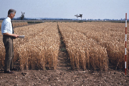
The Plant Breeding Institute (PBI) was established in 1912. Initially part of the University, it became a Research Institute in 1948. The site in Trumpington was acquired in 1950 and formally opened in 1955, with a headquarters building, glasshouses, research laboratories, workshops and other agricultural facilities. Many local people worked at the site, which was the former Anstey Hall Farm, extending from Trumpington village to Hauxton Mill. PBI was purchased by Unilever in 1987 and continued as Plant Breeding International Cambridge (PBIC). This became part of Monsanto in 1998 and the site was later sold to Grosvenor and named Trumpington Meadows. PBI and PBIC were a world centre for the development of new varieties of arable and herbage crops, such as Maris Piper potatoes and Consort wheat. The ‘Maris’ prefix was taken from Maris Lane, at the entrance to the site, which itself derived from the local Maris family.
C. The Prisoner of War Camp and Hostel
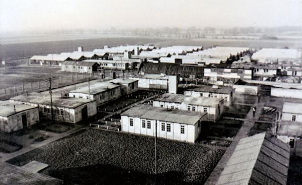
The Trumpington Prisoner of War (PoW) Camp was west of Hauxton Road, close to the Milestone (stop 4). It held Italian, Austrian and then German prisoners during and after World War II. The photograph was donated by the widow of one of the prisoners, Armin Renner of Chemnitz, Saxony, through Brother Herbert Kaden, who – with his mother – befriended prisoners during the War. At the time of an International Red Cross inspection on 9 February 1943, there were Italian prisoners, with a capacity of 750. In early 1945, it was described as a German working camp. By the end of 1945, it was an all Austrian camp, with Germans there from May 1946. A number of the prisoners worked on surrounding farms and were lodged with local farmers after the War. After the PoW camp closed in 1948 it became a National Service Hostel for the accommodation of men employed in the crucial post-war construction industry. The site finally closed in about 1954.
D. The Royal Showground
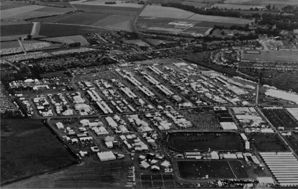
The annual Royal Show was run by the Royal Agricultural Society of England from 1839-2009. The farmland to the east of Shelford Road was used for the show in 1951, 1960 and 1961. These events were major celebrations of farming, with large-scale structures being erected and high visitor numbers. The shows in 1960 and 1961 were an experiment to demonstrate the advantage of not moving around the country each year, when canvass buildings and 20,000 railway sleepers used for roads had to be transported to each location. As a result, it was agreed to move the show to a permanent site at Stoneleigh and Francis Pemberton (who owned the Trumpington site) was responsible for establishing the new venue. Local residents remember the excitement of the shows and allowing their front drives and gardens to be used for parking.
Additional information
trumpingtonlocalhistorygroup.org
trumpingtonresidentsassociation.org
© TLHG and TRA, September 2016, updated April 2022.