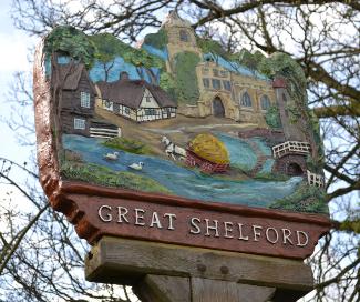
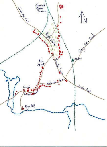
Trumpington to Great Shelford
Explore Great Shelford and Routes from Trumpington
Walk or cycle 6.3 miles/10.1 kms: walk on pavements and footpaths; cycle on roads and dual use paths. Option of bus from Great Shelford to Trumpington. Return route can be combined with Trail 7.
This is one of a series of history trails about Trumpington and its links to surrounding villages and Cambridge. We hope that long-established and new residents will find the trails to be a fascinating way to discover more about the history of the area.
The trails have been developed by the Trumpington Residents’ Association and the Trumpington Local History Group, with support from Cambridge City Council. The project is led by Andrew Roberts and Howard Slatter. Thanks to Helen Harwood for contributions to this trail.
Printed copies available free of charge from The Clay Farm Centre and Trumpington Pavilion.
Contact the Local History Group with feedback: admin@trumpingtonlocalhistorygroup.org.
Download a PDF version of the trail or continue with the route …
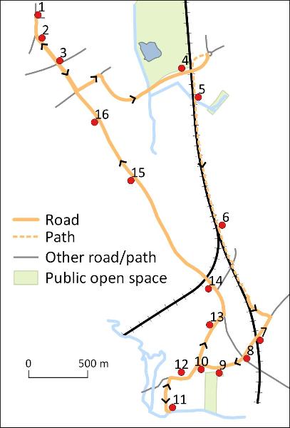
1. Start at the green by the shops, Anstey Way
2. Shelford Road
The generous width of Shelford Road reflects its use as a turnpike (Feature B). The earliest houses are on the left, with 3-11, 15-21 and 23-27 dating from the early 1900s and number 13 added in 1924, some with dates and names over the doors or on the wall. Houses further left and right were built from the 1920s. Continue to the bridge.
3. Shelford Road railway bridge
The Cambridge-Bedford railway opened in 1862 and closed in 1968. The route is now used by the Busway, opened in 2011. Continue to the junction and go left on Addenbrooke’s Road to the Abode development, stop at the roundabout (Trail 3). The apartments have metal screens with designs based on the fan vaulting in the ceiling of King’s College Chapel. Continue right on Addenbrooke’s Road, cross Hobson’s Brook and go up the slope towards the railway bridge.
4. Addenbrooke’s Road railway bridge
The railway bridge opened in 2010 and provides a viewpoint of Hobson’s Park to the left (Trail 5), Cambridge Biomedical Campus ahead (Trail 10) and the main railway line. Continue to the roundabout, follow the footpath/cycle path to the left, go under the railway bridge. The path to the left is on the line of the old parish boundary between Trumpington and Great Shelford. Continue ahead to the bridge over the stream.
5. Hobson’s Brook and Cycle Network
Hobson’s Brook runs from Nine Wells (the wood on the left, Trail 5) through Trumpington to Cambridge. The double helix sculpture and the design of 10,000 stripes painted on the path in 2005 commemorate DNA, the human genome and the National Cycle Network. Continue on the path, with White Hill Farm to the left, to the metal footbridge over the railway, built in 2014.
6. Webster’s Crossing and railway junction
The bridge replaced a level crossing named after the Webster family of nearby Granhams Farm. The railway lines to Liverpool Street and King’s Cross divide at this point, known as the Shepreth Branch Junction. Continue to the road, turn right, cross the road, and go on the DNA path this side of the railway line to Chaston Road. Bear right to Hinton Way, turn right to the level crossing.
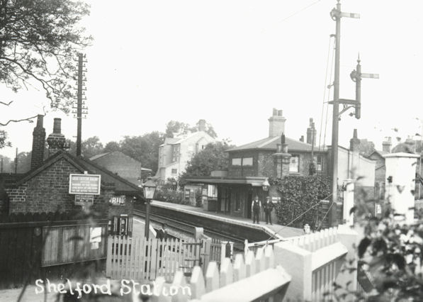
7. Shelford Station
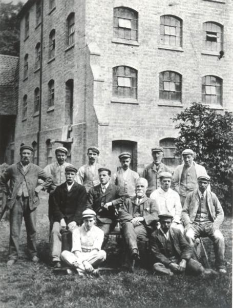
Shelford Station (Liverpool Street line) opened in 1845 (Feature C). The stationmaster lived at the station-house (now Zara Indian Restaurant). Goods and parcels were delivered to the goods yard behind the station and taken by horse and cart around the village. Chaston’s Steam Flour Mill was beyond the goods yard. Go over the level crossing. The road to the right of the crossing is on the site of the coal yard. There is an information panel in the bus stop. The Railway Tavern was to the left (demolished in 2016), with Shelford Corn and Coal beyond (later Shelford Energy). The mill and the coal yard were replaced by offices in the 1980s. Continue along Station Road to the junction.
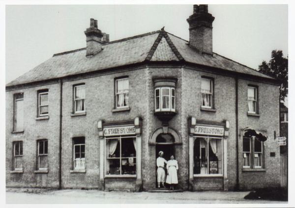
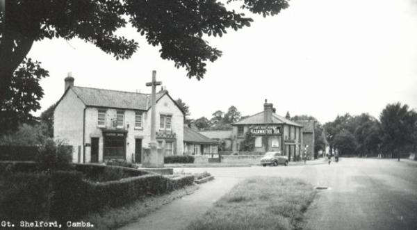
8. Freestone’s Corner
The corner is named after the bakery which stood here from 1904-84, now Reed House, see the plaque on wall. During World War II, Great Shelford was a billeting-place for soldiers. The Freestone family welcomed them and served refreshments. Cross London Road, the former turnpike, to the green, with the village sign and information plaques. Continue on Woollards Lane past Shelford Delicatessen, which has refreshments, and the Library, rebuilt in 2010.
In 1921, the Parish Council acquired two fields reaching to the river as a Recreation Ground (there is an attractive walk to the river). During World War II, it was an army camp. The hall was built in 1958 as a war memorial. Continue along Woollards Lane: most of the shops started as private homes, built in the 1900s-1930s. The baker’s (Days) has outdoor seating. The building opposite was used Barclays Bank from 1991 to c. 2020, on the site of Robinson’s Dairy. Continue to the junction.
10. The British School
The building to the left was the non-conformist British School, built in 1870. After it closed in 1906, Frederick Pumfrey used it as a garage. The site was redeveloped as housing in 2012. Go left along Church Street past the church, turn left into King’s Mill Lane and continue to the River Cam.
11. King’s Mill
There has been a corn mill here since Domesday, run by the Pearce family from the 1880s- 1950s, purchased by the architect Sir Leslie Martin in 1960 and converted into a house. The artist Ben Nicholson stayed here for a time. Turn back towards Church Street: King’s Mill House on the right was the setting for Philippa Pearce’s book, Tom’s Midnight Garden . Philippa was the miller’s daughter: there is a plaque in her memory on 4 King’s Mill Lane on the left. At the junction, there is an alternative walking route shown on a sign opposite (see Trail 7). To continue the main route, go right to the church.
St Mary’s Church was rebuilt about 1400. It has a Doom Painting above the chancel arch, depicting the Last Judgment. Numbers 15-19 opposite the church have been used as the Guildhall, brew house, workhouse and sheltered accommodation. Continue along Church Street: The Grange on the right is on the site of a Medieval manor house. On the left, the old phone box is put to novel uses. Go straight ahead along the High Street. Look out for swifts from May to August, there is a population in this area.
13. High Street
The Square and Compasses pub was originally a farm then a blacksmith’s home; The Plough opened as a pub in the 1830s, having originally been a blacksmith’s shop: both serve food. The green at the junction was given to the village by builder William Sindall, who lived nearby. The War Memorial was unveiled in 1921. Bear left on the main road, High Green (the bus stop has services to Trumpington), and continue towards the railway bridge (King’s Cross line).
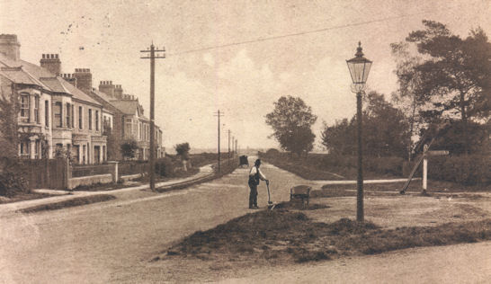
The approach to the bridge was originally an open green (Feature A). The houses to the left are set back with long front gardens which were part of the green. The house nearest the bridge, De Freville Manor, dates from 1500 or earlier, one of three manors in the village and a farmhouse until the early 2000s. The original turnpike alignment can be seen to the left of the bridge over the railway line. Go over the bridge, rebuilt in 1957-58 to allow for the eventual electrification of the railway. Continue along the turnpike route (Cambridge Road), look out for historic road names (Features B, D).
15. Scotsdales Nurseries/Rugby Ground
Until the early 1900s, there were no houses between Great Shelford and Trumpington. Scotsdales Garden Centre started as Davey’s Nurseries, opened about 1904, growing salad produce and cut flowers which were distributed by train (there is an old painted sign on the side of the house to the right of the entrance). There is a café in the garden centre. This side of the road, Shelford Rugby Club moved to the Davey Field (formerly part of the nurseries) in the 1960s. Percy Davey gave the land in memory of his son, Renford, an RAF pilot who died in World War II. Go on along the turnpike route.
16. Parish boundary and Milestone
The Cambridge sign marks the 1000 year old boundary between the parishes of Great Shelford and Trumpington. There is a small plaque commemorating the coronation of Queen Elizabeth II between the two street signs across the road and a turnpike milestone further on the left on this side of the road. This was an area of ribbon development of housing from the 1910s (look for houses dated 1914 and 1915 beyond the garage). Continue along Shelford Road to the junction. Turn right to Trumpington High Street to return to the green at Anstey Way.
A. Great Shelford history
Before 1800, Great Shelford was a corn-growing area, though farmers also had livestock to provide manure to fertilise the fields. Beyond the village, there were arable fields and long open roads until you reached the next village. Great Shelford was unusual in having two foci, with houses clustered around the church (along Church Street and High Street) and around High Green. It was only after the enclosure of the parish in 1835 that the Green was gradually built on and the two parts of the village merged. Enclosure was a big change: the old system of commoning – shared grazing for the village livestock and arable fields which were made of strips – was overturned. The fields were divided by hawthorn hedges and distributed to individual landowners. It became easy to sell your land for development and many more houses were built.
B. Turnpike Roads and Green Belt
From the 1720s, there were two turnpike roads from Cambridge to London which separated in Trumpington. The route via Great Chesterford is followed by Shelford Road (Trumpington) and Cambridge Road (Great Shelford). In the 1700s, this was a long, unfenced stretch of road, crossing the common or “waste” which was part of the common grazing of the two parishes. A series of milestones was placed along the turnpike, including one near the Trumpington/Great Shelford parish boundary (stop 16). Ribbon development of houses along the road began at the Trumpington end in 1901 (stop 2) and gradually spread from the 1910s (stop 16). Trumpington was incorporated in Cambridge in 1934, but the Green Belt between the city and the surrounding villages has survived largely intact, apart from a revision in 2006 which was followed by house building on Clay Farm, Glebe Farm and Trumpington Meadows.
C. Great Shelford and Railways
Just 10 years after enclosure in 1835, the railways arrived, with a dramatic effect on the local economy and society. The first railway through Shelford opened in 1845, from Shoreditch (later Liverpool Street) to Cambridge and Norwich. This was followed in 1851 by the line from King’s Cross to Cambridge and in 1865 by a branch line from Haverhill. Unlike Trumpington, Shelford had a station, built in 1845 on the Liverpool Street line, which gave the village good communication links. An industrial area developed nearby, including a large goods yard and sidings. The Corn and Coal Company sent grain to the markets of London and the Midlands, malt to the breweries in Burton-on-Trent, and brought in coal as fuel for local households. From the early 1900s, a number of market gardens grew up and distributed cut flowers and salad crops by rail.
D. Medieval Open Fields
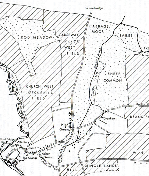
Prior to the 1835 Inclosure Act, Great Shelford village was surrounded by open fields. The railway line and cycle path (stop 5) mark the western limit of three of the arable fields: Nine Wells, Beans End and White Field. The turnpike, now Cambridge Road (stop 14), was the eastern limit of three other arable fields: Hauxton West, Church West and Causeway West Field. The land between the railway line and the turnpike was more low-lying, used as open grazing, with field names including Cabbage Moor and Sheep Common. Roads off Cambridge Road reflect the older names: Stonehill Road leads to a stone pit; Westfield Road to the West Field; May Pasture was where livestock were grazed in spring; and Cabbage Moor was an area of grazing.
Additional information
trumpingtonlocalhistorygroup.org
trumpingtonresidentsassociation.org
Great Shelford history (Helen Harwood): http://sites.google.com/site/greatshelfordhistory
Eating in Great Shelford:
Shelford Delicatessen, Woollards Lane
Days of Ashwell, Bakers, Woollards Lane
Barkers Butchers, High Street
The Square and Compasses, High Street
The Plough, High Street
© TLHG and TRA, September 2016.