Andrew Roberts gave a presentation about the history of the Long Road area at the Local History Group meeting on 27 September 2018. See also the presentations about the western part of the Long Road area by Howard Slatter and Barrow Road by Nick Bullock.
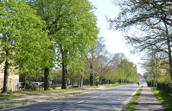
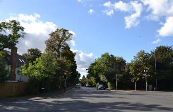
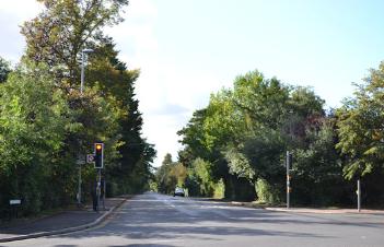
Looking east along Long Road towards the Lime Avenue junction. Andrew Roberts, 9 April 2017.
Context
The Long Road area is in the northern part of the historic parish of Trumpington. Trumpington parish originally extended to the east as far as Hills Road. The local topography includes two slight ridges followed by Trumpington Road and Hills Road, with Hobson’s Brook in the shallow valley between the ridges. There were Roman, Saxon and Medieval settlements and cemeteries around the areas which we now know as Trumpington village, the Addenbrooke’s area and Latham Road and Chaucer Road (Dam Hill). There was a probable road running diagonally across the valley from the Red Cross area towards Dam Hill.
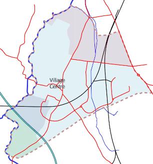
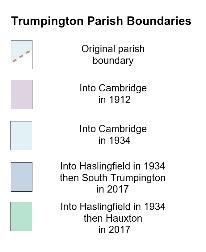
Trumpington Parish Boundaries: changes to Trumpington parish, March 2018. Howard Slatter.
Long Road up to 1912 Long Road is familiar to us as the long straight tree lined road linking Trumpington Road and Hills Road.
Long Road up to 1912
Long Road is familiar to us as the long straight tree lined road linking Trumpington Road and Hills Road.
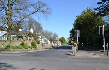
Left: the Trumpington High Street and Long Road junction; right: the Long Road and Hills Road junction. Andrew Roberts, 23 September 2018.
Left: the Trumpington High Street and Long Road junction; right: the Long Road and Hills Road junction. Andrew Roberts, 23 September 2018.
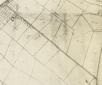
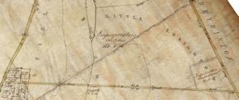
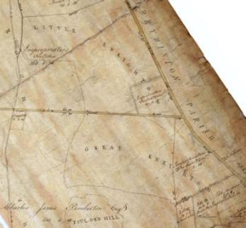
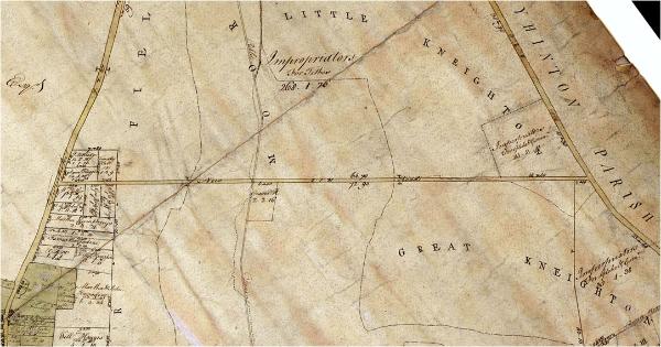
The earliest definitive information about the road is on maps produced to support the enclosure process in the early 1800s. The Inclosure Act was instigated by F.C.J. Pemberton and passed by Parliament in 1801, the land was divided after the 1802 harvest and the process was finally completed in 1809. One map of Trumpington parish is in the Pemberton Archive and probably dates to the beginning of the enclosure process, c. 1800-01. It shows ‘New Road’ (Long Road). It also records the old field names which had been used pre-enclosure: Moor Field east of Trumpington Road, The Moor both sides of Hobson’s Brook, Little Kneighton and Great Kneighton west of Hills Road, Foulden Hill to the south east. It was presumably produced before the division into fields and has no new field boundaries. There is no plantation alongside New Road but there is a gravel pit near the brook. The map does have the main inclosure award allocations, including Francis Charles James Pemberton and the Impropriators. It also shows properties and land holdings at the western end of the road which formed part of the allocations.
Trumpington Inclosure Map, c. 1800. Pemberton Archive, Trumpington Hall.
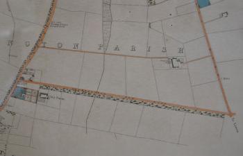
Another enclosure map in the Cambridgeshire Archives is dated 1804. The road is again named ‘New Road’. There are trees both sides of road, and a short length of plantation shown along the south side of the road towards the brook. This version of the map omits the old field names but does have new field boundaries. New Road is a significant boundary between land allocations and farms, with the area to the north of the road being primarily allocated to the ‘Impropriators and Francis Charles James Pemberton Esq. their Lessee’ and the area to the south of the road to ‘Francis Charles James Pemberton Esq.’. An unnamed building, Clay Farm House, has been added on the south side of the road, within the land allocation to F.C.J. Pemberton. The Victoria County History explains that “only after inclosure were some farmsteads built away from [the village], … Clay Farm, just south of the newly laid out Long road.” (VCH, p. 249). The names on the small parcels of land at the west end of the road include Samuel Haggis and Trinity Hall (north side of road) and William Ostler, George Headdey and Eliz. Bonning (south side).
A Map of the Parish of Trumpington in the County of Cambridge, 1804. Cambridgeshire Archives, R60/24/2/70(a).
A Map of the Parish of Trumpington in the County of Cambridge , 1804. Cambridgeshire Archives, R60/24/2/70(a).
The route of ‘New Road’ was probably used as a farm track before the Enclosure Award. Percy Robinson, who was the Head Teacher of Trumpington school in the 1920s, put together notes which he used as the basis for local history lectures. His page about ‘Long Road’ includes “Previous to the Enclosure Award this was nothing more nor less than a drift, simply a grass track used by carts, etc., consequently it was sometimes in a very bad state. It has had various names, Long Drift, Long Drove, New Road, Mill Road, Cherryhinton Road and Long Road.” He does not give any sources for this information but his statements were reliable.
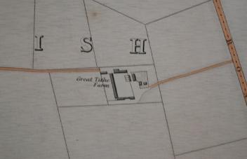
The next evidence for the road is Baker’s map of Cambridge, 1830, which has Trumpington New Road, with a plantation to south of the road for the length of the Pemberton holding. Clay Farm House is now named and there is a second farm, Great Tithe Farm, to the north east of the road. The mill and Mill House are shown near the junction with Trumpington Road. There is a large property called Weigh Bridge House, to the south of the Trumpington Road junction, with a weighing machine indicated close to the junction.
Long Road, Clay Farm House and Great Tithe Farm (Trinity Farm) on the coloured copy of Baker’s Map of Cambridge, 1830, Trumpington Village Hall. Andrew Roberts, 25 September 2018.
Long Road, Clay Farm House and Great Tithe Farm (Trinity Farm) on the coloured copy of Baker’s Map of Cambridge, 1830, Trumpington Village Hall. Andrew Roberts, 25 September 2018.
On the 1885 Ordnance Survey map, the road was known as Mill Road, presumably because of the existence of Trumpington Mill at its west end. By the early 1900s, the 1910-11 Land Value map (based on the 1903 Ordnance Survey map) has the road named ‘Long Road’ (in pencil), with the plantation to the south named ‘Mill Road Plantation’. There is similar evidence in the censuses, with ‘Mill Road’ used from 1851 to 1911, apart from ‘New Road’ in 1861 and a few entries for ‘Long Road’ in 1911. The censuses also show the slow build up of homes at the western end of the road, plus the farms and a gatehouse at the railway crossing.
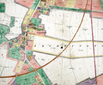
Inland Revenue Land Value map for Trumpington, 1910-11. Cambridgeshire Archives, file 470/047, sheet XLVII.10.
Inland Revenue Land Value map for Trumpington, 1910-11 . Cambridgeshire Archives, file 470/047, sheet XLVII.10.
North of Long Road
Extracts from the Trumpington Inclosure Map, c. 1800, Pemberton Archive, and Baker’s Map of Cambridge, 1830.
Extracts from the Trumpington Inclosure Map, c. 1800, Pemberton Archive, and Baker’s Map of Cambridge, 1830.
As part of the dissolution of the monasteries in 1539, Henry VIII removed land from Halliwell Priory (Shoreditch, north London). Henry granted this land to Trinity College at its foundation in 1546, including around 50 acres spread across Trumpington parish. The College was also given the village rectory and the right to appoint the vicar of St Mary & St Michael Church. At enclosure, the church tithes were commuted for land and this land together with the college land was consolidated into the area to the north of Long Road marked the ‘Impropriators and Francis Charles James Pemberton Esq. their Lessee’ on the 1804 map (Impropriators = lay rectors). This land was farmed by the Pemberton estate until the 1860s and then by Trinity College, and the main farm was initially known as Great Tithe Farm, later Trinity Farm. The name ‘Great Tithe’ related to the dues of oats, wheat and barley which had previously been paid to the church. The farmstead was built c. 1805 near Hills Road, in the area now occupied by the Perse School, to the east of Sedley Taylor Road and Luard Close. There was access to the farmstead from Trumpington Road and Hills Road. By the 1880s, a second dairy farm had been built to the north of Long Road, close to Clay Farm house, in the area now occupied by the BT Exchange.
Great Tithe Farm (Trinity Farm) on Baker’s Map of Cambridge, 1830. Trinity Dairy Farm on 1956 Ordnance Survey map.
Great Tithe Farm (Trinity Farm) on Baker’s Map of Cambridge, 1830. Trinity Dairy Farm on 1956 Ordnance Survey map.
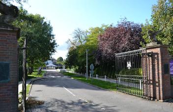
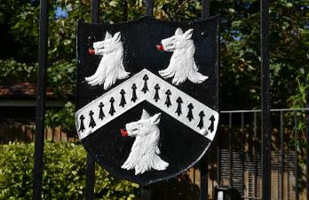
The Perse School and its crest, Hills Road gates. Andrew Roberts, 23 September 2018.
The Perse School and its crest, Hills Road gates. Andrew Roberts, 23 September 2018.
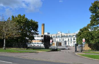
Left: Trinity Dairy Farm in the 1950s. Reg Cornwell (Stephen Brown). Right: the BT Telephone Exchange on Long Road, on the site of Trinity Dairy Farm. Andrew Roberts, 23 September 2018.
Left: Trinity Dairy Farm in the 1950s. Reg Cornwell (Stephen Brown). Right: the BT Telephone Exchange on Long Road, on the site of Trinity Dairy Farm. Andrew Roberts, 23 September 2018.
The Trinity College farm land to the north of Long Road was gradually developed for housing, with roads named after college fellows and officers, including Bentley Road from 1903, Barrow Road in the 1930s, Porson Road in the 1960s (on the line of a farm track) and Rutherford Road in the 1970s (on the location of the University polo field since the 1890s), and Sedley Taylor Road and Luard Road to the east of the railway line. Trinity Farm was demolished in 1938. A number of remaining areas of open land became sports grounds.
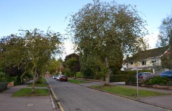
Rutherford Road. Andrew Roberts, 23 September 2018.
Rutherford Road. Andrew Roberts, 23 September 2018.
East end of Long Road
Extract from the Trumpington Inclosure Map, c. 1800, Pemberton Archive.
Extract from the Trumpington Inclosure Map, c. 1800, Pemberton Archive.
The Victoria County History has information about the Medieval field names of the land around the Hills Road end of Long Road (VCH, p. 258). This was divided by the 13th century into Great and Little Kinetun (later Great Kneighton and Little Kneighton) and Foulden Hill. The name cyne tun was Old English for royal or king’s manor , but there is no evidence of such a manor.
In October 2010, Countryside Properties decided to use ‘Great Kneighton’ as the marketing name of the Clay Farm and Glebe Farm developments. Cambridge City Council was unaware of this intention prior to the announcement and had no influence over marketing names. The Trumpington Residents’ Association, Trumpington Local History Group and local residents objected strongly to the adoption of the marketing name and regret that Countryside continued with its use throughout the building of homes on the new developments. The use of this name for the Clay Farm and Glebe Farm developments is historically inaccurate and detracts from the idea that the new developments are an integral part of Trumpington. The name will hopefully be forgotten once the developments are complete.
Left: the Long Road and Hills Road junction; right: new homes at the junction. Andrew Roberts, 23 September 2018.
Left: the Long Road and Hills Road junction; right: new homes at the junction. Andrew Roberts, 23 September 2018.
South of Long Road
Farmland to the south of Long Road to the east of the railway lines has been developed since the 1960s into Addenbrooke’s Hospital and now the Cambridge Biomedical Campus, including an access road, Robinson Way. Cambridgeshire High School for Girls was built in the 1940s and became Long Road Sixth Form College in 1974. The Cambridge Academy for Science and Technology opened to the south of the College in 2014 (named the University Technical College Cambridge until September 2017).
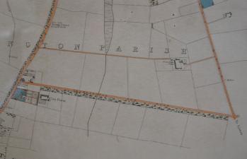
The land the south of Long Road between Trumpington High Street and the railway lines continued in use as farmland, Clay Farm, until the late 2000s (see the page about the west end of Long Road). In the 2006 Local Plan, approval was given for the development of the land for housing and it was purchased by Countryside Properties from the Pemberton estate. When Countryside Properties received the overall outline planning permission for the project in 2009-10, one of the first major steps was the design and building of the spine road from Long Road through Clay Farm to Addenbrooke’s Road, later named Lime Avenue and Hobson Avenue. This involved the realignment and widening of the central section of Long Road and the construction of the junction with Lime Avenue, with work carried out from 2011-12. This has been followed by the construction of homes, Trumpington Community College, etc., across the Clay Farm development in the 2010s.
Left: looking north east along Long Road from near Clay Farm house, as contractors start to remove trees in preparation for the construction of the Clay Farm spine road. Andrew Roberts, January 2011. Right: nearing the completion of work to widen Long Road at the new junction with Lime Avenue. Andrew Roberts, September 2012.
Left: looking north east along Long Road from near Clay Farm house, as contractors start to remove trees in preparation for the construction of the Clay Farm spine road. Andrew Roberts, January 2011. Right: nearing the completion of work to widen Long Road at the new junction with Lime Avenue. Andrew Roberts, September 2012.
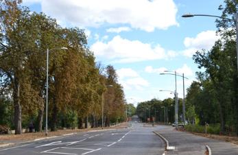
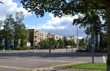
The Lime Avenue and Long Road junction. Andrew Roberts, 23 September 2018.
The Lime Avenue and Long Road junction. Andrew Roberts, 23 September 2018.
Railways across Trumpington
In 1845 and 1862, Long Road was crossed by two railway lines, from Cambridge to London and Cambridge to Bedford (see the pages on local railways ).
Inland Revenue Land Value map for Trumpington, 1910-11. Cambridgeshire Archives, file 470/047, sheet XLVII.10.
Inland Revenue Land Value map for Trumpington, 1910-11 . Cambridgeshire Archives, file 470/047, sheet XLVII.10.
Unlike in Great Shelford, no railway station was built in Trumpington. There was, however, a temporary station built to serve the 1922 Royal Show. The show covered the fields immediately north of Long Road, with the station in the gap between the London line and the Bedford line and to the east of the London line.
The Royal Show Station in use by freight and passengers, The Railway Magazine, 1922. Edmund Brookes.
The Royal Show Station in use by freight and passengers, The Railway Magazine , 1922. Edmund Brookes.
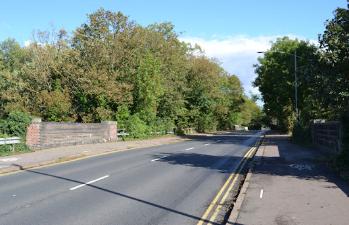
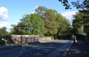
Since 1935, there have been two railway bridges on Long Road. When the Cambridge to Bedford line was constructed in 1862, bridges were installed at the outset, on Long Road, Shelford Road and Hauxton Road. It is understood that the Long Road bridge was rebuilt in the 1930s. The line closed in 1968 and the embankment to the west of the bridge was rebuilt in 2007 for the addition of the footpath and cycle path alongside the Busway. The Busway itself was constructed along the route of the railway in 2009. When the Cambridge to London line opened in 1845, there was a level crossing, signal box and gatehouse on Long Road. The Long Road bridge was built in 1935.
Left: the old railway bridge over the Cambridge-Bedford line, now the Busway, Long Road; right: the railway bridge over the Cambridge-London line, Long Road. Andrew Roberts, 23 September 2018.
Left: the old railway bridge over the Cambridge-Bedford line, now the Busway, Long Road; right: the railway bridge over the Cambridge-London line, Long Road. Andrew Roberts, 23 September 2018.
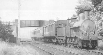
Local passenger train from Cambridge to Bedford, passing under Long Road bridge (now the Busway). Middleton Press.
Local passenger train from Cambridge to Bedford, passing under Long Road bridge (now the Busway). Middleton Press.
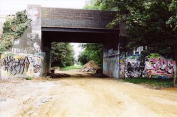
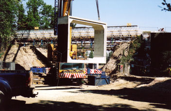
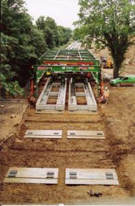
Left: the old railway bridge under Long Road, to the east of the new tunnel, to be used by the Busway; right: concrete structures being moved into place to create the new pedestrian/cycle tunnel. Andrew Roberts, August-September 2007.
Left: the old railway bridge under Long Road, to the east of the new tunnel, to be used by the Busway; right: concrete structures being moved into place to create the new pedestrian/cycle tunnel. Andrew Roberts, August-September 2007.
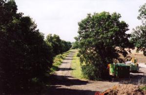
Left: footpath along the route of the Cambridge-Bedford railway, looking south from Long Road bridge, before work starts on the Busway. Andrew Roberts, Jul 2007. Centre: laying the Busway track, south of Long Road bridge. Andrew Roberts, July 2009. Right: the completed Busway track. Andrew Roberts, Aug 2009.
Left: footpath along the route of the Cambridge-Bedford railway, looking south from Long Road bridge, before work starts on the Busway. Andrew Roberts, Jul 2007. Centre: laying the Busway track, south of Long Road bridge. Andrew Roberts, July 2009. Right: the completed Busway track. Andrew Roberts, Aug 2009.
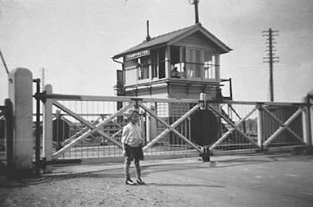
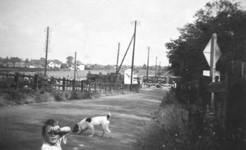
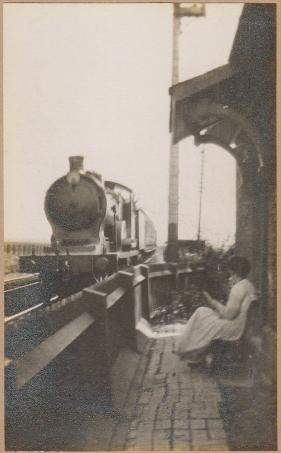
Left: Sarah Fairweather sitting outside the railway gatehouse, Long Road, 1920s?. Jane Fairweather. Right upper: the Long Road railway level crossing, with Roy Smith by the crossing gate; lower: looking towards Hills Road, with Roy Smith in the foreground, 1935. Cambridgeshire Collection, Cambridge Central Library (Stephen Brown).
Left: Sarah Fairweather sitting outside the railway gatehouse, Long Road, 1920s?. Jane Fairweather. Right upper: the Long Road railway level crossing, with Roy Smith by the crossing gate; lower: looking towards Hills Road, with Roy Smith in the foreground, 1935. Cambridgeshire Collection, Cambridge Central Library (Stephen Brown).
West end of Long Road
See the page by Howard Slatter for information about the west end of the road, including the mill, Clay Farm, etc.
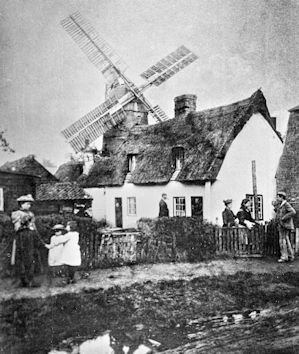
Windmill near the junction of Long Road (Mill Road) and Trumpington Road, 1873. Cambridgeshire Collection, Cambridge Central Library.
Windmill near the junction of Long Road (Mill Road) and Trumpington Road, 1873. Cambridgeshire Collection, Cambridge Central Library.
Sources
Cambridge City Council (2012). Cambridge Suburbs and Approaches. Long Road . Beacon Planning Ltd. March 2012. [https://www.cambridge.gov.uk/media/2945/suburbs-and-approaches-long-road.pdf]
Cambridge City Council (2012). Cambridge Suburbs and Approaches. Hills Road (including Babraham Road) . Beacon Planning Ltd. March 2012. [https://www.cambridge.gov.uk/media/2943/suburbs-and-approaches-hills-road.pdf]
Cambridge City Council (2012). Cambridge Suburbs and Approaches. Trumpington Road . Beacon Planning Ltd. March 2012. [https://www.cambridge.gov.uk/media/2948/suburbs-and-approaches-trumpington-road.pdf]
The Victoria History of the Counties of England (1982). A History of Cambridgeshire and the Isle of Ely, Volume 8. Armingford and Thriplow Hundreds . Edited by C.R. Elrington. Oxford: Oxford University Press for the Institute of Historical Research. ISBN 0-19-722757-0. [http://www.british-history.ac.uk/source.aspx?pubid=523].