Edited by Andrew Roberts
Trumpington’s history in the first half of the 19th century, including the enclosure of the village, the development of a network of farms, population growth and the building of the Cambridge-London railway. One of a series of pages with Trumpington’s timeline.
1801-50
Introduction to Trumpington in the 19th century.
Local History Group web page: 200 Years of Trumpington, 1801 to 2001.
1801
In response to an Act of Parliament, the population of each parish was assessed: Trumpington was made up of 60 inhabited houses, 0 uninhabited houses, 100 families and 494 people.
Sources of information: Lysons, Daniel and Lysons, Samuel (1808). Magna Britannia. Cambridgeshire. Republished 1978. Wakefield: EP Publishing. Page 23. The Victoria History of the Counties of England (1948). The History of the County of Cambridge & the Isle of Ely. Volume II, page 138. The Victoria History of the Counties of England (1982). A History of Cambridgeshire and the Isle of Ely, Volume VIII. Armingford and Thriplow Hundreds. Trumpington, page 249.
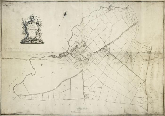
1801-09
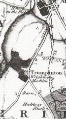
The inclosure of Trumpington was instigated by F.C.J. Pemberton in 1801. He procured an Inclosure Act with the reluctant agreement of Trinity College (the ‘rector’) and the Ansteys. The land was divided after the 1802 harvest and an inclosure map and field map were produced in 1804, but the inclosure award was delayed until 1809. The total area was 2312 acres.
Sources of information: Copy of the Inclosure Map, Cambridgeshire Archives, R60/24/2/70(a). The Victoria History of the Counties of England (1982). A History of Cambridgeshire and the Isle of Ely, Volume VIII. Armingford and Thriplow Hundreds. Trumpington, page 260.
Local History Group web pages: Introduction to the Agricultural Revolution and Enclosure of Trumpington; details of the Inclosure Act and Award; section in 200 Years of Trumpington, 1801 to 2001.
1805-
Lord Byron became a student at Trinity College, Cambridge, and is said to have swam in the river between Grantchester and Trumpington (the current ‘Byron’s Pool’).
Sources of information: McGann, Jerome (2009). ‘Byron, George Gordon Noel, sixth Baron Byron (1788-1824)’, Oxford Dictionary of National Biography.
1808
Daniel and Samuel Lysons published a ‘concise topographic account’ of Cambridgeshire, part of Magna Britannia, a planned series of county volumes. This included information about Trumpington village, the history of the manors and church and the archaeological background including prehistoric and Roman roads and finds. In a list of ‘gentlemen’s seats’, it gives two entries for Trumpington: F.C.J. Pemberton esq and the Reverend Christopher Anstey (in the occupation of Nathaniel Wedd esq). The Church is described as a “remarkably handsome uniform building” and there are illustrations of Medieval painted glass and Sir Roger’s tomb. They refer to three turnpike roads from Cambridge to London through Trumpington (the routes to Chesterford, Fowlmere and Royston).
Sources of information: Lysons, Daniel and Lysons, Samuel (1808). Magna Britannia. Cambridgeshire. Republished 1978. Wakefield: EP Publishing.
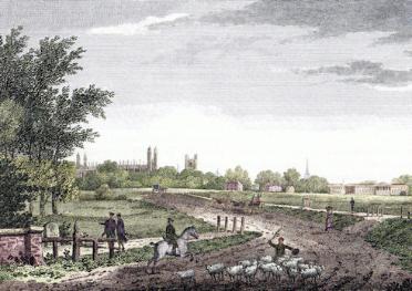
1809
R.B. Harraden published a book Cantabrigia Depicta, with illustrations of Cambridge including a plate showing the supposed scene from the bridge and milestone on the Trumpington parish boundary towards King’s College, with Coe Fen on the left and Hobson’s Conduit on the right of the road (page 192). He describes the context: “There are but few features to be seen in the different approaches to this town: the one from the London road is somewhat striking; the most conspicuous objects are King’s College chapel, the tower of Great St Mary’s Church, the spire of Trinity church and part of Downing college. See the view taken from the one-mile-stone on the London road.” (page 193).
Sources of information:
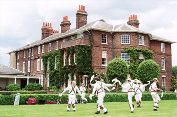
1810s-1820s
Remodelling of Trumpington Hall, including the addition of a third story under a low-pitched slated roof.
Sources of information: The Victoria History of the Counties of England (1982). A History of Cambridgeshire and the Isle of Ely, Volume VIII. Armingford and Thriplow Hundreds. Trumpington, page 254. Pevsner, Nicholas (1970). Cambridgeshire. The Buildings of England .
Local History Group web page: Trumpington Hall and the Pemberton Family.
1811
Population of Trumpington 508 people.
Sources of information: The Victoria History of the Counties of England (1948). The History of the County of Cambridge & the Isle of Ely. Volume II, page 138.
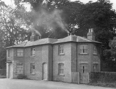
1811
A tollgate keeper’s house and weighbridge were constructed on the west side of the Cambridge road near the junction with the roads to Great Shelford and Grantchester (now Trumpington High Street). The building was sold in 1863 and is now a home.
Sources of information: The Victoria History of the Counties of England (1982). A History of Cambridgeshire and the Isle of Ely, Volume VIII. Armingford and Thriplow Hundred. Trumpington, page 249. Widnall, S.P. [Samuel Page] (1889). Reminiscences of Trumpington Fifty Years Ago. Pages 5-6.
Local History Group web page:
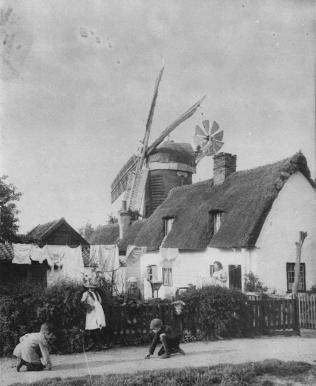
1812
Construction of a windmill to the east of Trumpington Road (on the north side of Long Road near the Long Road/Trumpington Road junction). The windmill is shown on Baker’s 1830 map, but the Victoria County History gives a date of 1831 for its construction. The mill belonged to the Moores from 1841 to c. 1900.
Sources of information: Baker, Richard Grey (1830). Baker’s Map of the University and Town of Cambridge, 1830: with an introduction . The Victoria History of the Counties of England (1982). A History of Cambridgeshire and the Isle of Ely, Volume VIII. Armingford and Thriplow Hundreds. Trumpington, page 261.
1821
Population of Trumpington 540 people.
Sources of information: The Victoria History of the Counties of England (1948). The History of the County of Cambridge & the Isle of Ely. Volume II , page 138. The Victoria History of the Counties of England (1982). A History of Cambridgeshire and the Isle of Ely, Volume VIII. Armingford and Thriplow Hundreds. Trumpington, page 249.
1821
Richard Grey Baker publishes a county map of Cambridgeshire which shows Trumpington.
Sources of information: The Victoria History of the Counties of England (1982). A History of Cambridgeshire and the Isle of Ely, Volume VIII. Armingford and Thriplow Hundreds. Page 161.
1827-31
Charles Darwin becomes a student at Christ’s College, Cambridge, graduating in 1831. Although Darwin travelled around the Cambridge area, Jon van Wyhe quotes only one reference to Trumpington: “Professor Sedgwick happened one day to mention a spring issuing from one of the chalk hills at Trumpington or Coton which deposited carb. of lime very prettily upon twigs &c. Darwin said to me ‘I shall go and test that water myself’, which he did and found the fact to be as Sedgwick had stated it.”
Sources of information: Desmond, Adrian, Moore, James and Browne, Janet (2009). ‘Darwin, Charles Robert (1809-1882)’, Oxford Dictionary of National Biography. Jon van Wyhe (2009), Darwin in Cambridge. Christ’s College.
1830s
Samuel Page Widnall writes about this period in his Reminiscences published in 1889. Widnall (1825-94) was a farmer who lived at the Old Vicarage, Grantchester, from 1850, and wrote and published books about local history.
Sources of information: Widnall, S.P. [Samuel Page] (1889). Reminiscences of Trumpington Fifty Years Ago . Jennings, Christine (2003). Widnall. A Capital Contriver. the Story of a Victorian Household in the Village of Grantchester.
1830s
Cuming’s School operating in a building to the east of the High Street near the Coach & Horses public house (a site at the corner High Street and Alpha Terrace, now occupied by St Mary’s House).
Sources of information: Widnall, S.P. [Samuel Page] (1889). Reminiscences of Trumpington Fifty Years Ago.
Local History Group web page: Education and schools in Trumpington.
1830
Richard Grey Baker publishes a map of Cambridge which shows most of the parish of Trumpington.
Sources of information: Baker, Richard Grey (1830). Baker’s Map of the University and Town of Cambridge, 1830: with an introduction. (Reproduction published by the Cambridgeshire Records Society in 1998.)
1831
Population of Trumpington 150 households, 722 people.
Sources of information: The Victoria History of the Counties of England (1948). The History of the County of Cambridge & the Isle of Ely. Volume II , page 138. The Victoria History of the Counties of England (1982). A History of Cambridgeshire and the Isle of Ely, Volume VIII. Armingford and Thriplow Hundreds. Trumpington, page 254.
1833
Publication of Lord Tennyson’s The Miller’s Daughter. Tennyson was a student at Trinity College from 1827 but left without a degree in 1831. The characters and the scenery in the poem were imaginary but Tennyson apparently said that if he thought of any mill it was that of Trumpington.
Sources of information: Ricks, Christopher (2006). ‘Tennyson, Alfred, first Baron Tennyson (1809-1892)’, Oxford Dictionary of National Biography.
1834-38
The ‘new’ Poor Law Amendment Act was passed in 1834. This took responsibility for the administration of poor relief from the parishes and placed it with a network of Unions. Trumpington was one of 38 parishes in the Chesterton Poor Law Union established on 2 April 1836, which covered a large area around Cambridge.
In 1836-38, the Union built a workhouse in fields in Chesterton, in what became known as Union Lane. The workhouse had accommodation for 300 people and was built on a prison model, with four arms making a cross, with intervening yards, and the master’s accommodation in the centre. It provided accommodation together with care for chronically sick paupers who were excluded from admission to hospital. In the 1930s, the workhouse was converted into a hospital named the Poor Law Infirmary. When the National Health Service was formed in 1948, Chesterton Hospital became part of the United Cambridge Hospitals. The buildings were demolished in 2003.
Most poor relief continued to be allocated to people living in the parishes (‘outdoor’ relief) rather than those placed in the workhouse. The Union appointed medical officers and took direct responsibility for the sick poor in the area. In 1849, it became a subscriber to Addenbrooke’s Hospital.
Sources of information: Talk to the Chesterton Local History Group about Chesterton Workhouse by Helen Harwood, 18 January 2011. Kirby, Tony and Oosthuizen, Susan (eds.) (2000). An Atlas of Cambridgeshire and Huntingdonshire History. Cambridge: Anglia Polytechnic University. Map 65. Rook, Arthur, Carlton, Margaret and Cannon, W. Graham (1991). The History of Addenbrooke’s Hospital Cambridge. Cambridge: CUP. Pages 129-31. The Victoria History of the Counties of England (1989). A History of the County of Cambridge and the Isle of Ely: Volume 9 – Chesterton, Northstowe, and Papworth Hundreds. Chesterton, page 12.
1837
There were 10 coaches every weekday from Cambridge to London.
Sources of information: The Victoria History of the Counties of England (1959). The History of the County of Cambridge & the Isle of Ely. Volume III. The City and University of Cambridge . City of Cambridge, page 1.
1838
Anstey Hall was purchased from the Anstey family by Cambridge banker Ebenezer Foster and remained in the Foster family from 1838-1941.
Sources of information: The Victoria History of the Counties of England (1982). A History of Cambridgeshire and the Isle of Ely, Volume VIII. Armingford and Thriplow Hundreds. Trumpington, page 254.
1840s
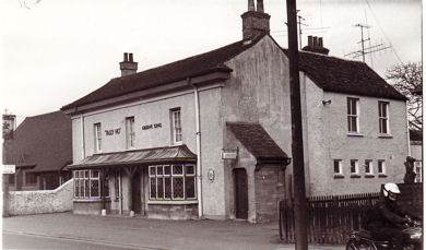
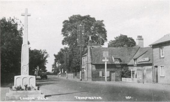
The Tally Ho public house was listed as a brew house when it opened on the east side of the High Street by the 1840s. It brewed its own beer until the early 1900s and was run for over 50 years by the same family, the Marshalls, first by James Marshalls then his son Thomas and finally James’s grandson Edwin.
The Red Lion public house also opened in the 1840s, also on the High Street, between the Tally Ho and the Green Man, nearly opposite the crossroads where the War Memorial was later erected.
Sources of information: Stephen Harper-Scott [January 2011]. The Victoria History of the Counties of England (1982). A History of Cambridgeshire and the Isle of Ely, Volume VIII. Armingford and Thriplow Hundreds. Trumpington, page 250.
Local History Group web page: Trumpington Public Houses.
1841
Census carried out on 6 June, population of Trumpington 759 people.
Sources of information: The Victoria History of the Counties of England (1948). The History of the County of Cambridge & the Isle of Ely. Volume II , page 138. The Victoria History of the Counties of England (1982). A History of Cambridgeshire and the Isle of Ely, Volume VIII. Armingford and Thriplow Hundreds. Trumpington, page 249.
Local History Group web page: 1841 Census of Trumpington.
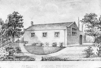
1842-43
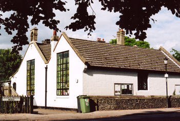
Purchase of a site and building of the Church School (National School) on the north side of Church Street. The school opened in 1843 and was only replaced by the opening of Fawcett School in 1950.
Sources of information: The Victoria History of the Counties of England (1982). A History of Cambridgeshire and the Isle of Ely, Volume VIII. Armingford and Thriplow Hundreds. Trumpington, page 266.
Local History Group web page: Education and schools in Trumpington.
1845
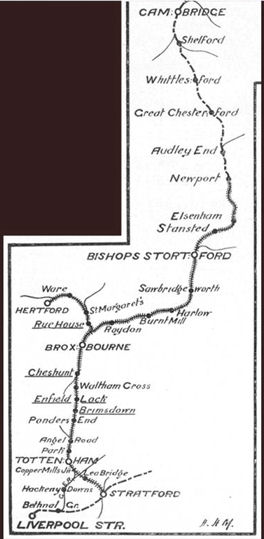
Construction of the London-Cambridge-Norwich railway line, the Great Eastern Railway, running from south to north through the parish to the east of Hobson’s Brook, from Shelford Station to Cambridge Station. Opened 30 July 1845.
Sources of information: The Victoria History of the Counties of England (1948). The History of the County of Cambridge & the Isle of Ely. Volume II , page 132. The Victoria History of the Counties of England (1982). A History of Cambridgeshire and the Isle of Ely, Volume VIII. Armingford and Thriplow Hundreds. Trumpington, page 250.
Local History Group web page: Introduction to Railways in Trumpington and The Railways of Trumpington, 1845-2010.
1849
The last stagecoach ran from Cambridge to London.
Sources of information: The Victoria History of the Counties of England (1959). The History of the County of Cambridge & the Isle of Ely. Volume III. The City and University of Cambridge. City of Cambridge, page 1.