Edited by Andrew Roberts
The first stage in Trumpington’s history: Neolithic, Bronze Age and Iron Age settlement and farming from the end of the last glaciation to 0 BC. One of a series of pages with Trumpington’s timeline.
‘Before Trumpington’
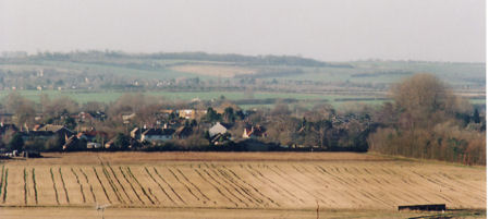
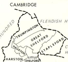
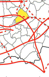
The timeline is concerned with the area that became the historic parish of Trumpington, a roughly triangular area of about 2300 acres to the south of Cambridge.
Sources of information: Taylor, Alison (1999). Cambridge: the Hidden History . The Victoria History of the Counties of England (1982). A History of Cambridgeshire and the Isle of Ely, Volume VIII. Armingford and Thriplow Hundreds. Trumpington, page 248.
Glacial and interglacial periods
The Cambridge region was affected by the series of glaciations, the last of which resulted in vast quantities of gravel being deposited in the river valleys. There is evidence of human habitation in the Cambridge area in the inter-glacial periods.
Sources of information: Kirby, Tony and Oosthuizen, Susan (eds.) (2000). An Atlas of Cambridgeshire and Huntingdonshire History. Cambridge: Anglia Polytechnic University. Map 1. Taylor, Alison (1999). Cambridge: the Hidden History. Page 15.
Post-glacial topography
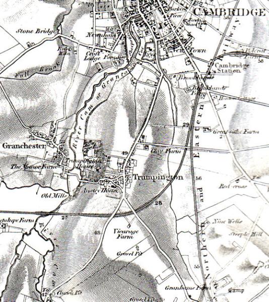
The dominant topographic feature of the area to the south of Cambridge is the valley of the River Cam and its tributaries. The land on either side of the river is very fertile, reasonably light and easily worked, with gravel and clayey alluvial soils. Christopher Evans describes the area as ‘a pinchpoint in the landscape’, where a network of river tributaries flow between ridges to the west and east.
Topography of Trumpington from west to east: River Cam with Second Terrace gravels on the western edge of area, c. 9-11 m OD; pronounced slope up from river valley with lower chalk and Third Terrace gravel immediately to the east of the river valley in the Trumpington Meadows area; current village centre and the area to the north west of the current main road on a low ridge running from south to north, Third Terrace gravels, c. 17-18 m OD; lower land to the east of the village with the Vicar’s Brook (Hobson’s Brook) running through it in a trough, Second Terrace gravels and clay and marl beds, poorly drained, c. 12-13 m OD; further slope up to the east towards and beyond the current railway line, Clay Farm; low downlands to the south, Lower Chalk. Parish bounded by the River Cam to the south west and west and Vicar’s Brook to the north.
Sources of information: Archaeology reports and visits to archaeological sites. Evans, Christopher, with Duncan Mackay and Leo Webley (2008). Borderlands. The Archaeology of the Addenbrooke’s Environs, South Cambridge. Cambridge: Cambridge Archaeological Unit. Pages 15, 141-43, 193-96. Kirby, Tony and Oosthuizen, Susan (eds.) (2000). An Atlas of Cambridgeshire and Huntingdonshire History. Cambridge: Anglia Polytechnic University. Map 1. Oosthuizen, Susan (1996). Cambridgeshire from the Air . Stroud: Alan Sutton Publishing. Page vii. Steers, J.A. (1965). The Cambridge Region. London: British Association. Page 85. The Victoria History of the Counties of England (1982). A History of Cambridgeshire and the Isle of Ely, Volume VIII. Armingford and Thriplow Hundreds. Trumpington, page 248.
Local History Group web page: Archaeological Reports.
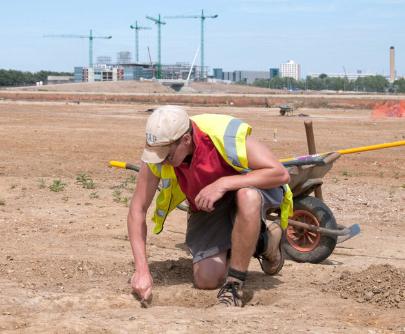
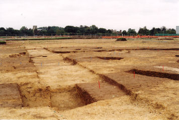
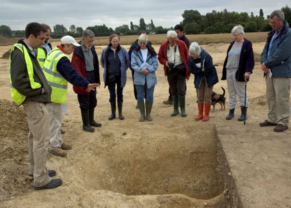
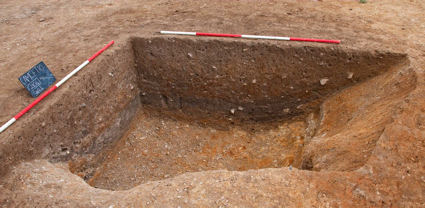
Early human occupation
There is extensive evidence of human occupation in the Trumpington area during the last 5000 years. Much of this has been revealed by detailed archaeological field work and excavations in advance of developments around the southern fringe of the previously built-up area, including – from west to east – Trumpington Meadows, the Park & Ride site, Glebe Farm, Clay Farm and the Cambridge Biomedical Campus/Addenbrooke’s Hospital sites.
Recent research has identified a far greater density of Iron Age and Roman settlement in the area than had been understood by previous generations of archaeologists such as Cyril Fox.
Sources of information: Archaeology reports and visits to archaeological sites. Cambridgeshire Historic Environment Record (Sites & Monuments Record), searchable through the Heritage Gateway. Evans, Christopher, with Duncan Mackay and Leo Webley (2008). Borderlands. The Archaeology of the Addenbrooke’s Environs, South Cambridge. Cambridge: Cambridge Archaeological Unit. See in particular the chapter by Christopher Evans, ‘Environs Fieldwork and Distributional Case-studies’, pages 141-86, including maps of archaeological sites and cropmarks.
Local History Group web page: Archaeological Reports. Clay Farm Archaeology, August 2010. Early History of the Shelford Road area.
Neolithic, c. 4000-2400 BC
The Neolithic period included the introduction of farming, the use of pottery and more sophisticated stone tools.
The River Cam was part of a north-south route from the Fens to the Thames. One prehistoric trackway may have run between Great Chesterford, Great Shelford, Trumpington and Grantchester (the line followed by the current Shelford Road), with a ford at the River Cam between Trumpington and Grantchester. This may have intersected with another trackway on the line of the current Great Shelford-Trumpington parish boundary. The Prehistoric Icknield Way ran south west to north east, a few miles to the south of the area.
Archaeological excavations at the Trumpington Meadows site in 2010-11 revealed evidence of Neolithic occupation, including three probable Neolithic ring-ditch monuments on the ridge to the east of the river valley, with Mildenhall and Peterborough ware pottery and burials, and pottery from north Cambridgeshire (Cambridge Archaeological Unit).
Sources of information: Archaeology reports and visits to archaeological sites. Evans, Christopher, with Duncan Mackay and Leo Webley (2008). Borderlands. The Archaeology of the Addenbrooke’s Environs, South Cambridge. Cambridge: Cambridge Archaeological Unit. Fox, Cyril (1923). The Archaeology of the Cambridge Region. Cambridge: Cambridge University Press. Pages 111-14, 150-52. Kirby, Tony and Oosthuizen, Susan (eds.) (2000). An Atlas of Cambridgeshire and Huntingdonshire History. Cambridge: Anglia Polytechnic University. Map 11. Taylor, Alison (1999). Cambridge: the Hidden History. Page 15, 127. The Victoria History of the Counties of England (1978). The History of the County of Cambridge & the Isle of Ely. Volume VII: Roman Cambridgeshire. Page 28.
Local History Group web page: Archaeological Reports.
Bronze Age, c. 2400-800 BC
Archaeological work has identified field systems and settlement patterns around Trumpington village. The archaeological excavations at Trumpington Meadows in 2010-11 identified possible Early Bronze Age burials (Cambridge Archaeological Unit). On the Clay Farm site to the east of Shelford Road, excavations in 2009-10 identified a network of Middle Bronze Age ditches which may have been field boundaries and a settlement or work area. Work continued in other parts of Clay Farm in 2011, with rich evidence from the Middle Bronze Age (Oxford Archaeology East). The excavation at the Hutchison site in 2002-03 revealed substantial evidence of use in the Late Bronze Age and again in the Late Iron Age and Roman periods.
Sources of information: Archaeology reports and visits to archaeological sites. Evans, Christopher, with Duncan Mackay and Leo Webley (2008). Borderlands. The Archaeology of the Addenbrooke’s Environs, South Cambridge. Cambridge: Cambridge Archaeological Unit. Kirby, Tony and Oosthuizen, Susan (eds.) (2000). An Atlas of Cambridgeshire and Huntingdonshire History. Cambridge: Anglia Polytechnic University. Map 9.
Local History Group web page: Archaeological Reports. Clay Farm Archaeology, August 2010.
Iron Age, c. 800 BC – 70 AD
Iron Age/Roman farming settlements were widely established both sides of the River Cam. In Borderlands, Christopher Evans argues that there was a far greater density of settlement than had been assumed by earlier researchers, with sites at intervals of 300-500 metres across the area and quite a high population level. There were hill forts at Wandlebury and on the north west bank of the Cam (the area of the later Cambridge Roman settlement).
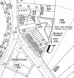
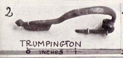
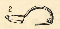
In his thesis on The Archaeology of the Cambridge Region published in 1923, Cyril Fox argued that the ford between Trumpington and Grantchester was the lowest convenient crossing of the Cam and that there would have been pre-Roman routes from Chesterford to Trumpington and on an alignment from the area of Trumpington Hall to Dam Hill and the Leys School (to the west of the modern road). Writing in the Victoria County History in 1938, J. Grahame Clark went so far as to say that the “twin settlements at Grantchester and Trumpington, on either side of the ford of the Cam, were the Early Iron Age predecessors of Cambridge …”. Within the Trumpington area, Iron Age/Roman settlements have been identified in locations including the river valley south of the ford to Grantchester; a gravel pit opposite the cemetery to the east of the High Street/Shelford Road junction (now the rear of the first houses on Shelford Road); the grounds of Anstey Hall; to the west of Trumpington Road; on the Hutchison and Addenbrooke’s Hospital sites; and along Hills Road. There was an important Iron Age/Roman cemetery at Dam Hill (the area between Latham Road, River Farm, and Chaucer Road). Cyril Fox refers to Iron Age evidence from Trumpington, including a brooch (see figures) and pottery beakers, bowls and amphorae. Unfortunately, many of the areas that might have provided evidence were affected by coprolite digging in the 19th century and sites such as Dam Hill were identified before systematic excavation techniques were developed.
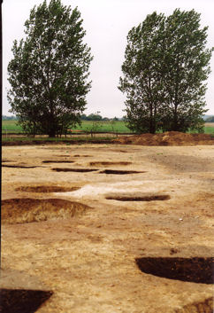
Archaeological excavations to the south west of the current village centre (on the Park & Ride site in 2000-01 and the adjacent part of the Trumpington Meadows site in 2010-11) have identified 100s of pits which may have been associated with domestic occupation of the terrace. The 2010 work also found a number of burials (Cambridge Archaeological Unit).
Research at Clay Farm has identified important Iron Age evidence, including Late Iron Age occupation and farming patterns to the east of Shelford Road (Oxford Archaeology East). This area continued in use into the Roman period before being abandoned before the end of the 2nd century. Excavations at the Hutchison site in 2002-03 showed that it was heavily used in the Late Iron Age.
Sources of information: Archaeology reports and visits to archaeological sites. Evans, Christopher, with Duncan Mackay and Leo Webley (2008). Borderlands. The Archaeology of the Addenbrooke’s Environs, South Cambridge. Cambridge: Cambridge Archaeological Unit. Page 19; pages 132, 141 and 151 for maps of archaeological sites and cropmarks; pages 197-200 for overview. Fox, Cyril (1923). The Archaeology of the Cambridge Region. Cambridge: Cambridge University Press. Pages 70-120, 150-52. Kirby, Tony and Oosthuizen, Susan (eds.) (2000). An Atlas of Cambridgeshire and Huntingdonshire History. Cambridge: Anglia Polytechnic University. Map 10. 12 and 14. Oosthuizen, Susan (1996). Cambridgeshire from the Air. Stroud: Alan Sutton Publishing. Page 7. Taylor, Alison (1999). Cambridge: the Hidden History. Page 18-20, 41. The Victoria History of the Counties of England (1938). The History of the County of Cambridge & the Isle of Ely, Volume I. Page 285-92. The Victoria History of the Counties of England (1982). A History of Cambridgeshire and the Isle of Ely, Volume VIII. Armingford and Thriplow Hundreds. Trumpington, page 248.
Local History Group web page: Archaeological Reports. Clay Farm Archaeology, August 2010.