Edited by Andrew Roberts
Five hundred years in Trumpington’s history: Medieval development, including changes following the Norman conquest, the building of the Church and the Black Death. One of a series of pages with Trumpington’s timeline.
11th century
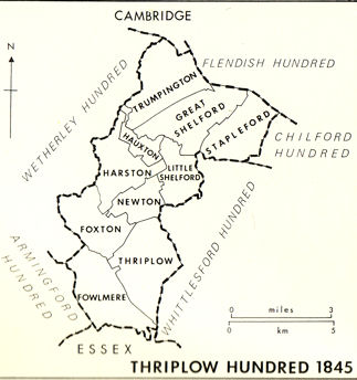
Trumpington was part of Thriplow Hundred, an area stretching along the east bank of the River Cam or Rhee from the Essex border to Cambridge. The Hundred was known by this name before 1066, probably taking the name from a meeting place at Thriplow itself. Other parishes in the Hundred include Harston, Hauxton, Newton and Little Shelford to the south west of Trumpington and Great Shelford and Stapleford to the south east. All the villages in the Hundred were nucleated and the northern villages mostly developed near a river crossing approached by a side street leading from a main street parallel with the river, with a church and manors in the intervening space.
Sources of information: Kirby, Tony and Oosthuizen, Susan (eds.) (2000). An Atlas of Cambridgeshire and Huntingdonshire History. Cambridge: Anglia Polytechnic University. Map 31. The Victoria History of the Counties of England (1982). A History of Cambridgeshire and the Isle of Ely, Volume VIII. Armingford and Thriplow Hundreds. Thriplow Hundred, pages 152-54.
1016
The English accepted the Danish Cnut (Canute) as their king.
Sources of information: Medieval London gallery, Museum of London.
1042-57
The English prince Edward (the Confessor) regained the throne. King Edward gave a charter to the monks of Ely on all the properties that the church owned, including land outside the Isle in Trumpington [named Trumpentune, Trumpintune].
Sources of information: Liber Eliensis. A History of the Isle of Ely from the Seventh Century to the Twelfth, Compiled by a Monk of Ely the Twelfth Century. Translated by Janet Fairweather (2005). Woodbridge: Boydell Press. Page 191.
1066
After the Norman invasion: the area was quickly taken by the Normans. In 1068, William I visited Cambridge and ordered the construction of a castle. Picot was the sheriff of Cambridge from 1070-92. The settlement pattern was one of continuity rather than change.
Sources of information: Dr Sam Newton, Cambridge and the Kingdom of East Anglia, Institute of Continuing Education, University of Cambridge, November 2009. History of Cambridge University, Web page. Kirby, Tony and Oosthuizen, Susan (eds.) (2000). An Atlas of Cambridgeshire and Huntingdonshire History. Cambridge: Anglia Polytechnic University. Map 33. Taylor, Alison (1999). Cambridge: the Hidden History. Pages 51-59. The Victoria History of the Counties of England (1959). The History of the County of Cambridge & the Isle of Ely. Volume III. The City and University of Cambridge. Medieval Cambridge, page 5 and Public Buildings, page 116-18.
1085-86
King William commissioned the Domesday Survey in December 1085. The Commissioners held an enquiry in Cambridge into the wealth of each Hundred in the county of ‘Grentebrigscire’. Following these enquiries, the evidence from the Survey was summarised in the Domesday Book in 1086. It gives information about land ownership and occupation for 1066 and 1086.
The account of ‘Grentebrige‘ (Cambridge) is limited, but shows that it was already an important town, assessed as a separate Hundred made up of ten wards.
The sites of the villages in the area have been consistent since Domesday.
Trumpington is referred to as ‘Trumpinton/Trumpintone’ and consisted of 37 households (about 185 people including 33 peasants and 4 slaves), with four manors. A mill at Trumpington was held by William de Warenne. There was a weir rendering 450 eels and pasture for the cattle of the vill.
Sources of information: The National Archives, Domesday, catalogue reference E 31/2/1. PASE database (Prosopography of Anglo-Saxon England). Darby, H.C. (1971). The Domesday Geography of Eastern England. 3rd edition. Cambridge: Cambridge University Press. Gray, E.A. (1977). Hobson’s Conduit, the Story of a Cambridgeshire Chalk Stream. Page 17. Kirby, Tony and Oosthuizen, Susan (eds.) (2000). An Atlas of Cambridgeshire and Huntingdonshire History. Cambridge: Anglia Polytechnic University. Map 34. Morris, John (editor) (1981). Domesday Book. A Survey of the Counties of England, compiled by Direction of King William I, Winchester 1086. Chichester: Philimore. Taylor, Alison (1999). Cambridge: the Hidden History. Pages 127. The Victoria History of the Counties of England (1938). The History of the County of Cambridge & the Isle of Ely. Volume I. Pages 335-414. The Victoria History of the Counties of England (1948). The History of the County of Cambridge & the Isle of Ely. Volume II. Page 50. The Victoria History of the Counties of England (1959). The History of the County of Cambridge & the Isle of Ely. Volume III. The City and University of Cambridge. Medieval Cambridge, page 3-5.The Victoria History of the Counties of England (1973). The History of the County of Cambridge & the Isle of Ely. Volume V. Grantchester, page 208. The Victoria History of the Counties of England (1982). A History of Cambridgeshire and the Isle of Ely, Volume VIII. Armingford and Thriplow Hundreds. Trumpington, page 249.
11th -14th centuries
The population density of the area to the south of Cambridge was around 35-50 per sq. mile at the time of the Domesday Survey. The population increased up to c. 1300, with the extension of existing villages and the continued expansion of farmland. The corn trade was a basis for the prosperity of Cambridge and the surrounding area.
Sources of information: Darby, H.C. (1971). The Domesday Geography of Eastern England. 3rd edition. Cambridge: Cambridge University Press. Pages 5-7, 37-40. The Victoria History of the Counties of England (1959). The History of the County of Cambridge & the Isle of Ely. Volume III. The City and University of Cambridge. Medieval Cambridge, page 6 and Economic History, page 87.
11th-16th centuries
There was a complex pattern of Medieval manors in Trumpington.
One manor was held by the Trumpington family from the 12th to the 16th centuries. It was later sold to the Pychard family then the Pemberton family. The original hall may have been a 13th century manor house on the same site as the current Trumpington Hall.
Another manor was the land given to Ely Abbey by Ealdorman Beorhtnoth in 991. The Domesday Survey recorded that 4½ hides (about 500 acres) were held by the Abbey by the thegn Tochi. A ‘thegn’ (thane) was an aristocratic retainer of the king or a nobleman. ‘Thegnland’ was a type of landholding like a tenure limited to a single lifetime: the land remained owned by the Abbey with the landholder owing some sort of service to the Abbey. Tochi was described as a great king’s thegn. This land was seized by a Norman lord, Frederick de Warenne, and later held by the de Cailly family. It was sold to the Pychard family in the 16th century.
A third manor was near the church before 1279, later rebuilt as Anstey Hall.
Sources of information: Farrer, William (1920). Feudal Cambridgeshire. Cambridge: University Press. Pages 219-23. Lysons, Daniel and Lysons, Samuel (1808). Magna Britannia. Cambridgeshire. Republished 1978. Wakefield: EP Publishing. Pages 269-70. Miller, Edward (1951). The Abbey and Bishopric of Ely. Cambridge: CUP. Pages 52-53. Taylor, Alison (1999). Cambridge: the Hidden History. Pages 127-30. The Victoria History of the Counties of England (1982). A History of Cambridgeshire and the Isle of Ely, Volume VIII. Armingford and Thriplow Hundreds. Trumpington, page 251-57.
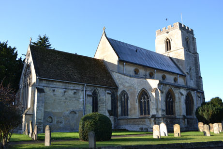
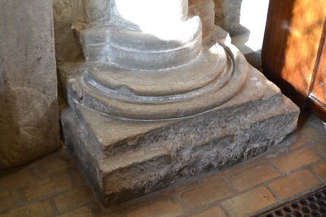
c. 1200
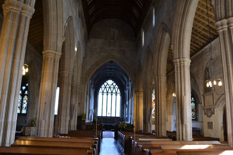
Initial phase of building the current Trumpington Parish Church: the base of the west respond of the south arcade survives from this date. The church was originally dedicated to St Nicholas.
Sources of information: Ambrose, Tom (2006). St Mary & St Michael Trumpington. Hicks, Carola (ed.) (1997). Cambridgeshire Churches. Stamford: Paul Watkins for Cambridgeshire Historic Churches Trust. Pages 63-64, 91. Pevsner, Nicholas (1970). Cambridgeshire. The Buildings of England. Royal Commission on Historical Monuments (England) (1959). An Inventory of the Historical Monuments in the City of Cambridge. Part II. London: HMSO. Page 294-98. The Victoria History of the Counties of England (1982). A History of Cambridgeshire and the Isle of Ely, Volume VIII. Armingford and Thriplow Hundreds. Trumpington, page 262.
Local History Group web page: Introduction; History of the Parish Church; Benefitting the Soul: Life and Religion in Late Medieval Trumpington.
13th century
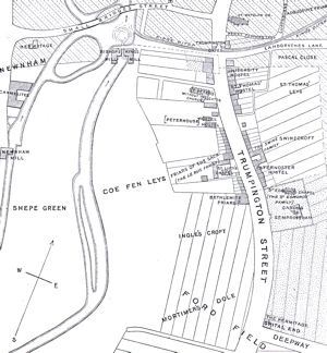
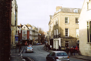
By the 13th century, there was a tollgate called ‘Trumpington Gate’ or ‘Trumpington Gates’ on the south side of Cambridge, on the road to Trumpington. This was adjacent to St Botolph’s Church and the ‘King’s Ditch’ which circled the south and east of the town. (There was a second gate called ‘Barnwell Gate’ to the east, near the present Great St Andrew’s Church.)
St Botolph was the patron saint of travellers and churches dedicated to him were sometimes found at or near city gates. Writing in 1908, Rev. H.P. Stokes was not able to establish when the Trumpington Gates were first set up, but they predate 1266. Stokes says that there is an allusion to them in a document in Corpus Christi College Archives and the use of the plural is assumed to refer to double gates.
Stokes argued that there were dwellings beyond the Ditch in the 13th century and produced a possible plan of the area. The parishes of St Botolph and St Benet were partly located outside the King’s Ditch while St Peter’s parish (‘St Peter without the Trumpington Gates’, later ‘St Mary the Less’) extended south of the Ditch to the boundary with Trumpington. Stokes gives details of the owners and occupants of properties outside the gates from the 13th century, including ownership by the Cayley’s of Trumpington. Peterhouse was founded by the Bishop of Ely in 1284.
Stokes adds that as late as the 18th century, the high street through Cambridge up to the junction with Bridge Street was occasionally called Trumpington Road.
Sources of information: National Monuments Record web site. St Botolph’s Church. Kirby, Tony and Oosthuizen, Susan (eds.) (2000). An Atlas of Cambridgeshire and Huntingdonshire History. Cambridge: Anglia Polytechnic University. Map 55. Stokes, H.P. (1908). Outside the Trumpington Gates Before Peterhouse was Founded. Cambridge: Cambridgeshire Antiquarian Society. Taylor, Alison (1999). Cambridge: the Hidden History. Pages 45-49, 86. The Victoria History of the Counties of England (1959). The History of the County of Cambridge & the Isle of Ely. Volume III. The City and University of Cambridge. Medieval Cambridge, page 3 and Growth of the City, page 110.
1209
Cambridge University was founded in 1209. In the early decades, students lived in lodgings and then in hostels; there were no colleges.
Sources of information: History of Cambridge University web site [accessed 14 December 2010]. Darby, H.C. (1971). The Domesday Geography of Eastern England. 3rd edition. Cambridge: Cambridge University Press. Pages 37-40.
1210-11
The right to hold Sturbridge Fair [Stourbridge Fair] near the river on the east side of Cambridge was granted by King John, c. 1210-11. By 1589, it was by far the largest and most famous fair in England. It was used as a model for Vanity Fair in John Bunyan’s Pilgrim’s Progress, published in 1678
Sources of information: Darby, H.C. (1971). The Domesday Geography of Eastern England. 3rd edition. Cambridge: Cambridge University Press. Page 45. Ridout, Honor (2011). Cambridge and Stourbridge Fair. Cambridge: Blue Ocean. The Victoria History of the Counties of England (1959). The History of the County of Cambridge & the Isle of Ely. Volume III. The City and University of Cambridge. Economic History, page 92-95.
1220
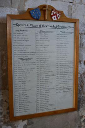
First Rector (Hendricus) and Vicar (Ioce or Jocius) of Trumpington Parish Church.
Sources of information: Panel in Church.
Local History Group web page: Parish Church: Vicars and Rectors.
1264-66
Trumpington and other villages raided by supporters of Simon de Montfort.
Sources of information: Taylor, Alison (1999). Cambridge: the Hidden History. Pages 75, 127.
1279
The Hundred Rolls include details of Cambridge, where university students were still living in hostels rather than colleges. The population of Trumpington had increased to around 100 landowners (nearly 80 houses and cottages).
Sources of information: Darby, H.C. (1971). The Domesday Geography of Eastern England. 3rd edition. Cambridge: Cambridge University Press. Pages 37-40. Taylor, Alison (1999). Cambridge: the Hidden History. Page 127. The Victoria History of the Counties of England (1982). A History of Cambridgeshire and the Isle of Ely, Volume VIII. Armingford and Thriplow Hundreds. Trumpington, page 249.
1284-1550
The first of the Cambridge University colleges, Peterhouse, was founded in 1280, followed by 12 other colleges by 1550. The University also developed its central Schools near Cambridge market. The developments required the clearance of large areas between the market and the river, to the west of the road to Trumpington.
Sources of information: History of Cambridge University web site. Darby, H.C. (1971). The Domesday Geography of Eastern England. 3rd edition. Cambridge: Cambridge University Press. Pages 37-40.
1289
Death of Sir Roger de Trumpington (see 1320s for the memorial brass).
Sources of information: Ambrose, Tom (2006). St Mary & St Michael Trumpington. Carr, Edith (1968), The Story of Trumpington Church . Pevsner, Nicholas (1970). Cambridgeshire. The Buildings of England . The Victoria History of the Counties of England (1982). A History of Cambridgeshire and the Isle of Ely, Volume VIII. Armingford and Thriplow Hundreds. Trumpington, page 253.
Before 1300
The Middle English language evolved out of Old English.
Sources of information: Evolving English: One Language, Many Voices, exhibition at the British Library, 2010-11.
14th century
It was a day’s journey from London to Cambridge.
Sources of information: The Victoria History of the Counties of England (1959). The History of the County of Cambridge & the Isle of Ely. Volume III. The City and University of Cambridge. City of Cambridge, page 1.
Late 13th – early 14th century
Most of the structure of the current Trumpington Parish Church dates from the early 14th century, starting with the west tower and chancel c. 1300 then the nave early 14th century. Carola Hicks comments that the splendid churches in the villages around Cambridge reflect the growing prosperity of the intellectual centre.
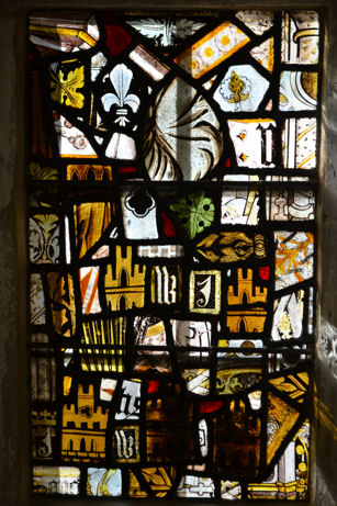
The Church would have been enhanced by stained glass. Most of the glass depicting saints and biblical figures was destroyed during the Reformation, but examples with heraldic motifs and purely decorative areas have survived and are in south and west windows of the chancel.
Sources of information: Trumpington Parish Church Web site. The Corpus Vitrearum Medii Aevi (CVMA) Web site about Medieval stained glass. Ambrose, Tom (2006). St Mary & St Michael Trumpington. Hicks, Carola (ed.) (1997). Cambridgeshire Churches. Stamford: Paul Watkins for Cambridgeshire Historic Churches Trust. Pages 63-64, 91, 276-77. Pevsner, Nicholas (1970). Cambridgeshire. The Buildings of England. Royal Commission on Historical Monuments (England) (1959). An Inventory of the Historical Monuments in the City of Cambridge. Part II. London: HMSO. Page 294-98. The Victoria History of the Counties of England (1982). A History of Cambridgeshire and the Isle of Ely, Volume VIII. Armingford and Thriplow Hundreds. Trumpington, page 264-65.
Local History Group web page: Introduction and History of the Parish Church.
1300 – c. 1450
The Cambridge area was among the most densely settled and wealthy regions in the country in the late 13th and 14th centuries. However, the parishes to the south of Cambridge contracted in population from around 1330, with arable land going out of cultivation. There were episodes of Black Death in 1348-50 and the 1360s and 1370s. Great Shelford was severely affected by plague in 1361.
Sources of information: Darby, H.C. (1971). The Domesday Geography of Eastern England. 3rd edition. Cambridge: Cambridge University Press. Pages 16-17. Spufford, Margaret (2000). Contrasting Communities. English Villagers in the Sixteenth and Seventeeth Centuries. Stroud: Sutton Publishing. Pages 4-10.
1314
Trumpington Feast was founded by charter, to take place on 1 August (in the 19th century, this changed to the eve, day and morrow of St Peter & St Paul, 28-30 June).
Sources of information: The Victoria History of the Counties of England (1982). A History of Cambridgeshire and the Isle of Ely, Volume VIII. Armingford and Thriplow Hundreds. Trumpington, page 251.
Local History Group web page: Trumpington Charter Fair, 1968.
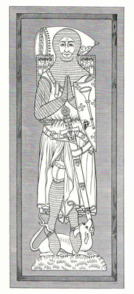
1320s
A monument to the Trumpington family was placed between the north aisle and north chapel of the Parish Church, probably in the late 1320s. This is a table-tomb under an ogee arch, with a memorial brass set in a slab of Purbeck marble on its upper surface. The brass is 6ft 4in long and shows an effigy thought to be of a crusader, a knight in mail armour and surcoat, with feet resting on a dog, with a sword and shield charged with the arms of Trumpington. The brass is thought to date from the 1320s and may be the second oldest surviving military brass in England. The brass is often ascribed to Sir Roger de Trumpington (died 1289) but assessments by the Royal Commission on Historical Monuments (1959), archaeologist Denys Spittle (1970) and the Victoria County History (1982) concluded that its history was more complex. Spittle argued that the brass may originally have been designed for Sir Roger’s son, Giles de Trumpington (died between 1327 and 1332), then altered in devotion to Giles’s son who predeceased him, Roger de Trumpington (died 1326). The tomb has clunch sides, with the south side altered by the insertion of memorial tablets to Thomas Pytcher and William Pitcher (1577 and 1614).
Sources of information: Ambrose, Tom (2006). St Mary & St Michael Trumpington. Carr, Edith (1968). The Story of Trumpington Church. Hicks, Carola (ed.) (1997). Cambridgeshire Churches. Stamford: Paul Watkins for Cambridgeshire Historic Churches Trust. Pages 303-04. Lysons, Daniel and Lysons, Samuel (1808). Magna Britannia. Cambridgeshire. Republished 1978. Wakefield: EP Publishing. Page 65. Moule, A.C. (1922). ‘Some Trumpington Inscriptions, with Special Reference to the Base of the Old Village Cross’, Proceedings of the Cambridge Antiquarian Society, 24, p. 95-109. Pevsner, Nicholas (1970). Cambridgeshire. The Buildings of England. Royal Commission on Historical Monuments (England) (1959). An Inventory of the Historical Monuments in the City of Cambridge. Part II. London: HMSO. Page 297. Spittle, S.D.T. (1970). ‘The Trumpington Brass’, Archaeological Journal, 127, p. 223-27.
Local History Group web page: History of the Parish Church.
1327
The Lay Subsidy was a tax levied by the Crown on the value of moveable goods (farm equipment, large domestic animals, surplus crops, etc.). The 1327 Subsidy listed every taxpayer by name and the amount payable. The list for Trumpington named 48 taxpayers, including Egidio de Trumpeton, Johe Arnold and Thomas Chapman. Once the total liability for each area was established, it was used as the basis for taxation for the next 300 years.
Sources of information: Hesse, Mary (2000). ‘The Lay Subsidy of 1327’. In Kirby, Tony and Oosthuizen, Susan (eds.) (2000). An Atlas of Cambridgeshire and Huntingdonshire History. Cambridge: Anglia Polytechnic University. Map 36. Muskett, J.J. (1903-08). Lay Subsidy for the Year 1327, Cambridgeshire and Isle of Ely: The East Anglian. Trumpington, pages 36-37. The Victoria History of the Counties of England (1982). A History of Cambridgeshire and the Isle of Ely, Volume VIII. Armingford and Thriplow Hundreds. Trumpington, page 249.
1377
The Poll Tax was levied on individuals in 1377, 1379 and 1381. The total liability for Thriplow Hundred was £24 10s 0d in 1377. The tax was abandoned after the Peasants Revolt in 1381.
Sources of information: Fenwick, Carolyn C. (1998). The Poll Taxes of 1377, 1379 and 1381. Part 1. Bedfordshire-Leicestershire. Records in Social and Economic History, NS27. Oxford: University Press for the British Academy. Cambridgeshire, pages 68-71.
c. 1390
Geoffrey Chaucer (c. 1340-1400) writes The Canterbury Tales. His wife was a friend of Lady Blanche de Trumpington and he may have known the village. Chaucer’s ‘The Reeve’s Tale’ is thought to be based on a mill in or near Trumpington:
“At Trumpington, not fer fro Cantebridge,
There goth a brook, and over that a bridge,
Upon the whiche brook there stant a melle”
(The Canterbury Tales, Penguin Popular Classics)
Trumpington mill belonged in the 13th century to the Trumpington family, held as successors to the Caylys, who had inherited the mill held in 1086 by William de Warenne, but Chaucer’s reference may be to Hauxton Mill: this was more likely to be the mill used as a model by Chaucer.
Sources of information: Evolving English: One Language, Many Voices, exhibition at the British Library, 2010-11. Gray, Douglas (2004). ‘Chaucer, Geoffrey (c.1340-1400)’, Oxford Dictionary of National Biography, Oxford University Press. Taylor, Alison (1999). Cambridge: the Hidden History. Page 130. The Victoria History of the Counties of England (1973). The History of the County of Cambridge & the Isle of Ely. Volume V. Grantchester, page 208. The Victoria History of the Counties of England (1982). A History of Cambridgeshire and the Isle of Ely, Volume VIII. Armingford and Thriplow Hundreds. Hauxton and Newton, page 201.
1419
King Henry V used English in written instructions, the first time for 300 years that it had taken precedence over French in government documents.
Sources of information: Evolving English: One Language, Many Voices, exhibition at the British Library, 2010-11.
15th century
There was no fighting in the Cambridge area during the War of the Roses.
Sources of information: The Victoria History of the Counties of England (1959). The History of the County of Cambridge & the Isle of Ely. Volume III. The City and University of Cambridge. Medieval Cambridge, page 13.
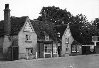
15th century
The Green Man public house in Trumpington was originally a 15th century timber-framed hall-house.
Sources of information: The Victoria History of the Counties of England (1982). A History of Cambridgeshire and the Isle of Ely, Volume VIII. Armingford and Thriplow Hundreds. Trumpington, page 250.
Local History Group web page: The Green Man public house.
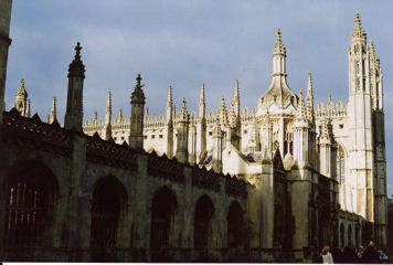
1446-1515
Building of King’s College Chapel.
Sources of information: Pevsner, Nicholas (1970). Cambridgeshire. The Buildings of England.
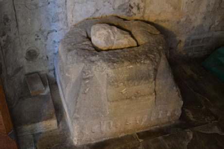
c. 1480
A village cross was erected after 1476 on ‘Cross Hill’, where Church Lane joins the High Street. The Barnack stone base of the cross had a socket for a wooden shaft and the inscription “Orate pro animab[us] Joh[ann]is Stokton et Agnetis uxoris ei[us]” [Pray for the souls of John Stokton and of Agnes his wife]. John and Agnes Stokton probably lived in a house on the north west side of Church Lane (in the area now occupied by the Unicorn pub (now The Lord Byron Inn)). Stokton may have been a farmer (in the 16th century, there was a Stokton Farm of 100 acres). John Stokton was referred to in the Subsidy Rolls in 1450 but had died before 1476.
The placing of the cross at the ‘Cross Hill’ location suggests that the focus of the village may have moved from the area around the Church to this more north easterly area by the 15th century.
The base was rediscovered during the erection of the War Memorial on 17 August 1921. It was given to the Parish Church and is now under the Church tower.
Sources of information: see the Cross Hill page.
Local History Group web pages: John and Agnes Stokton; Cross Hill.
c. 1500
Most of the arable land in south Cambridgeshire was still farmed in open fields, in contrast to the Midlands where the enclosure movement was active.
Sources of information: Darby, H.C. (1971). The Domesday Geography of Eastern England. 3rd edition. Cambridge: Cambridge University Press. Page 26.