East of the Village Centre
The Growth of Trumpington Since the 19th Century
Walk or cycle 2 miles/3.2 kms: walk on pavements and footpaths; cycle on roads and dual use paths
This is one of a series of history trails about Trumpington and its links to surrounding villages and Cambridge. We hope that long-established and new residents will find the trails to be a fascinating way to discover more about the history of the area.
The trails have been developed by the Trumpington Residents’ Association and the Trumpington Local History Group, with support from Cambridge City Council. The project is led by Andrew Roberts and Howard Slatter.
Printed copies available free of charge from The Clay Farm Centre and Trumpington Pavilion.
Contact the Local History Group with feedback: admin@trumpingtonlocalhistorygroup.org .
Download a PDF version of the trail or continue with the route …
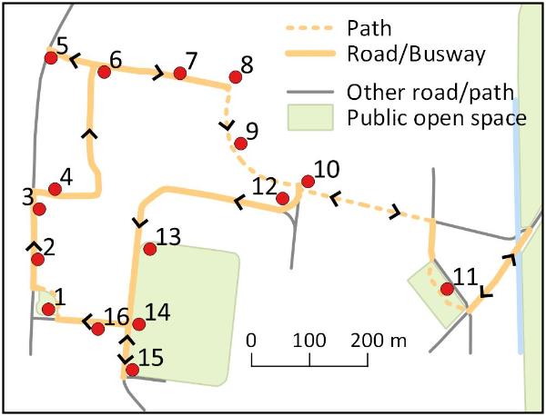
1. Start at the green by the shops, Anstey Way
2. High Street houses
The houses on the right were built in the second half of the 1800s, mainly to house farm workers. The exception was the original number 85, now renumbered to 83, where the village policeman usually lived until a police house was built in Church Lane about 1905. The present number 85 has been rebuilt: it is on the site of Swan’s Yard, a row of seven houses at right angles to the main road. Continue along the High Street.
3. Hudson’s Ale House and Village Hall
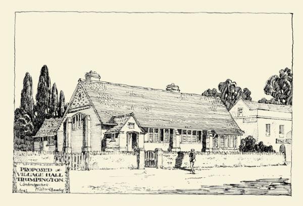
Hudson’s Ale House was renamed in October 2015. It was first recorded as a beer house in the 1840s, named the The Tally Ho!, which brewed its own beer until about 1900. The early frontage was much plainer; the bay windows and porch roof were added in about the 1930s. Continue past the Village Hall, opened in 1908 (Trail 1), to the junction with Beverley Way. On the other side of the High Street, Bidwells was built on the site of the blacksmith’s in 1986, and the War Memorial was unveiled in 1921, in the same location as the Medieval village cross (Trail 1).
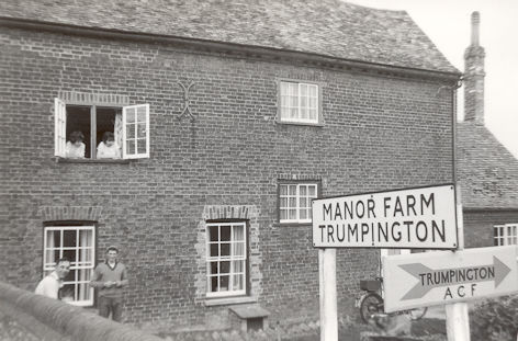
Beverley Way is on the site of Manor Farm, whose fields extended from here to the east. There was a track to Red Cross Farm, Hills Road, the line of which is followed by Beverley Way, Paget Road and through Clay Farm (stop 10). The farm house was on the further side of Beverley Way, demolished in 1968-71. Go along Beverley Way and turn left into Scotsdowne Road, both built in the 1970s. Continue to Alpha Terrace, turn left and go to the High Street.
St Mary’s House on the left at the junction was built about 1880 on the site of an earlier house which was used as a private school from 1783-1842 (Feature A). In recent years, it was used by a home furnishings company, before being converted into a home in 2015-16. The house on the right is Alpha Cottage, which gave its name to Alpha Terrace. Return along Alpha Terrace to Scotsdowne Road.
6. Trumpington Free Church
The Free Church opened in 1899, when it was the only non-conformist place of worship in the village. It is now used by Cambridge Community Church as a community and educational centre. Continue along Alpha Terrace.
7. Alpha Terrace
The building of Alpha Terrace started in the 1880s and by 1911 the right hand side was almost complete (Feature B). The gates just beyond the church were the entrance to Scott’s builder’s yard. A number of houses have original names and dates on their walls, including Grantchester Cottages opposite the yard. Others have attractive glass above their doors, including numbers 42 and 44. Stop at the school gates.
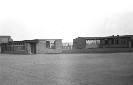
8. Fawcett Primary School
Fawcett Junior School opened in 1949 and Infant School in 1950, when many families were moving to the nearby newly-built estate. The schools combined into Fawcett Primary School in 1989. The oak tree near the school entrance was planted by the Trumpington WI in 1999, to celebrate the millennium. With another phase of house building, the school was extended in size in 2015. Turn right on the footpath.
9. Professional Development Centre
The former Fawcett Infant School became the Cambridge Professional Development Centre (CPDC), a County Council facility which provides resources for conferences, meetings and seminars. Bear left where the path forks and continue to the exit. The latest extension of Fawcett School is to the left, opened September 2015, with new buildings on Clay Farm and the Cambridge Biomedical Campus straight ahead.
10. Clay Farm
Go through the exit gate to the edge of the 1940s estate. Construction work may still be underway on the Clay Farm development, but if the path to the left is open, go along this, with Fawcett School playing field on your left. This path is on the route of one of the tracks from Trumpington village to farmland and Red Cross Farm (stop 4, Trail 10). At the road, go right to Hobson Square. (If the path is closed, take the signed alternative to Hobson Square.) From the enclosure of the parish in 1809, Clay Farm extended from Long Road to Shelford Road. The land continued to be farmed until 2007, when it was taken out of the Green Belt for housing and community use.
11. Hobson Square and Hobson’s Park
Hobson Square and the Clay Farm Centre open in 2016-17, with local shops and a library, hall, community rooms, café and health centre (Trail 5). The rill across the square and the layout of the front and rear entrances of the Clay Farm Centre match the alignment of a Bronze Age field boundary. From the square, go left along the Busway path to the bridge over Hobson’s Brook, which takes spring-water from Nine Wells to Cambridge (Trails 2, 3 and 5). Cross the Busway to access Hobson’s Park (Trail 5). To continue, retrace the route to the exit from CPDC, where there is a small green (stop 10).
12. The 1940s Estate
Planned before World War II, the estate was eventually built in the 1940s to meet demand from within Cambridge for modern well-appointed council houses. There is a variety of housing styles including prefabricated steel-framed houses, now mainly disguised by different cladding materials. Paget Close on the left consists of flats. Go right along Paget Road, where numbers 90 to 126 on the left are examples of steel-framed houses. Continue to the playing field.
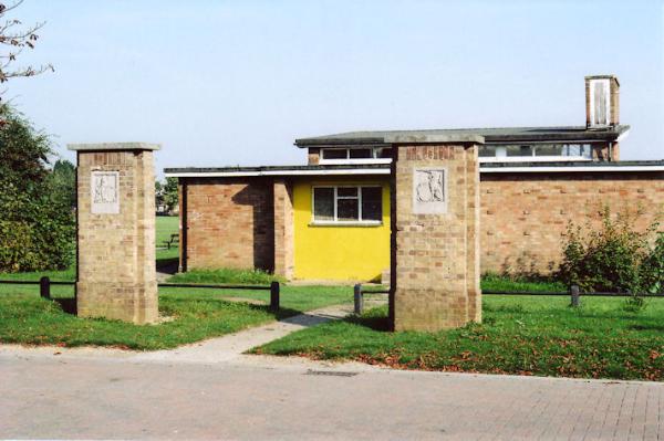
13. The King George V Playing Field
The Playing Field was dedicated in 1951 in memory of King George V (Feature D). It now includes play areas, a football pitch and tennis court. Go past the tennis court to the Pavilion.
The original Pavilion was built in the late 1950s and used as changing rooms for the football pitch and as a youth club. In 2009, the City Council rebuilt it and Trumpington Pavilion opened as a community centre managed by the Trumpington Residents’ Association. The original pillars in front of the building commemorate King George V, with heraldic panels showing the royal Lion and Unicorn. Continue along Foster Road a short distance to the junction with Byron Square.
15. Trumpington Bowls Club
Trumpington Bowls Club started on a green adjacent to The Unicorn (now the Lord Byron Inn) in Church Lane. In 1953, it moved to the new playing field. From 1988 to 2000, it also provided bowling facilities for members of the University. Go back to Trumpington Pavilion, turn left and continue along Anstey Way.
16. Anstey Way
The bungalows and flats on the right were built by the Council in the 1950s, on the site of the old village recreation ground. A group of 26 Council flats and houses was demolished in December 2017 and replaced with Wilson Court (named after the Wilson brothers who died in World War 1), built during 2019-20 and occupied from February 2020: two apartments with 56 homes (one, two and three-bedroom Council rented apartments). This was developed by the Cambridge Investment Partnership, a joint project between the City Council and Hill. From about 1925 until World War II, there was a house and nursery garden (Crossways) on the left: catalogues from the 1930s list Casburn, Bedford and Page as nurserymen there, specialising in alpine and herbaceous plants and shrubs. The house was finally demolished in the early 1980s. Return to the green.
A. Mr Cuming’s School
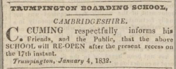
Between 1783 and 1842, James Cuming (or Cumming) and his son Charles ran a boarding school in a building where St Mary’s House now stands (on the High Street at the Alpha Terrace junction, stop 5). In return for payments from one of the village charities, Cuming admitted some of the village children to the school. Samuel Widnall, in his Reminiscences of Trumpington Fifty Years Ago published in 1889, recalled his time at the school. Widnall wrote: “Mr. Cumming senior used to live in the house since called Alpha Cottage adjoining the school. I believe he built it when he gave up the school to his son Charles; he was in my time a very aged man and blind, to entertain him we boys used to be sent to repeat some of our more interesting lessons to him… Mr. Cumming at this time was unmarried, and his sister lived with him as housekeeper; she was always kind and considerate to us boys, and so indeed was he, but, he had of course to keep up the dignity of his office, so we naturally used to think him rather stern… The school-room was almost filled with desks fixed to the floor, except at the lower end where the large double desk stood used for the village children.”
B. Alpha Terrace
The entrance to Alpha Terrace from the High Street is beside Alpha Cottage, which was the house adjoining Mr Cuming’s school in the early 1800s. The first houses in Alpha Terrace were built by Charles Scott in the 1880s and the road took its name from the cottage. The north side (odd numbers) was developed first; Charles Scott’s son, Nathan, lived at the present number 3, which was then the first house in the road. By the time of the 1911 census, almost the whole of the south side had been built, and Charles Scott was living at number 22, with his builder’s yard beside it. The Free Church, built by the Scotts, opened in 1899. There was a sawmill between the church and St Mary’s House (on the corner with the High Street), operated by the Sheldrick and Chapman families, but this was closed in the 1920s after the solicitor Mr Griffith Todd, who lived at St Mary’s House, complained about the noise. The house was used as a doctor’s surgery in the 1950s.
C. ‘The Estate’
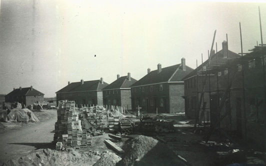
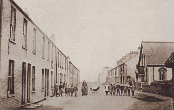
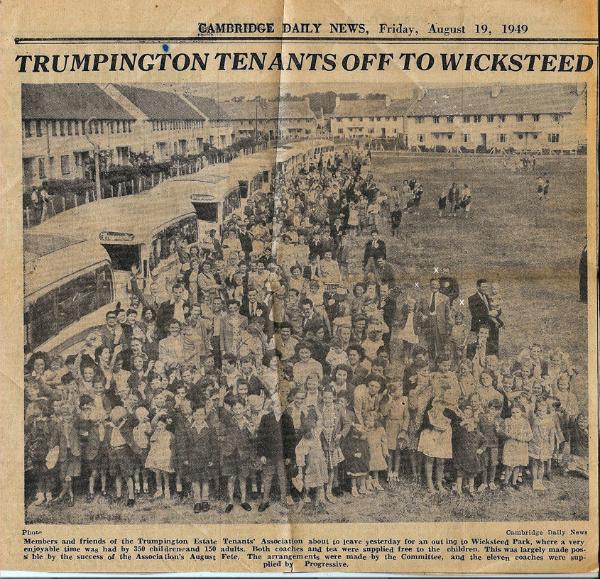
In 1936, Cambridge Borough Council decided to develop several new housing estates around the town, one of them on farmland in Trumpington. The need to rehouse families who were in substandard accommodation in the town was pressing, but the Second World War delayed the implementation of the plan. Eventually building got under way in 1946 and by late 1948 all the houses and flats on the new estate were occupied. A total of 328 houses and 32 flats were built in Byron Square, Foster Road, Paget Road and Paget Close. Sixty two of the houses were of pre-fabricated design, with steel frames. The first families to move into the estate came from across Cambridge, but they soon included several who were moved out from old buildings in Trumpington, particularly from Whitelock’s Yard, Swan’s Yard (both in the High Street) and Church Lane.
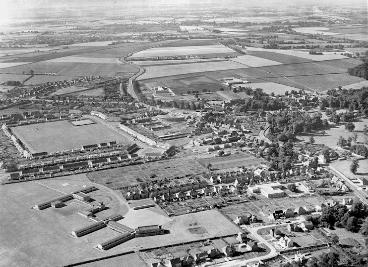
D. King George V Playing Field
The King George V playing field was one of a network established in memory of King George V after he died in 1936. The Council planned the Estate and play area in the late 1930s, but work was delayed by the War. The playing field was eventually dedicated on 23 January 1951. Its initial appearance was much starker than today, with an open area surrounded by the new houses. The first structures on the field were two memorial columns, the bowling green and a rectangular area (cricket pitch?). An aerial photograph from c. 1955 shows the scale of the playing field at the centre of the housing development (see header).
Additional information
trumpingtonlocalhistorygroup.org
trumpingtonresidentsassociation.org
© TLHG and TRA, September 2016, updated April 2022.