Andrew Roberts
April 2025
A. Introduction
“Shape, size and character vary greatly. No village is quite like any other. And this, of course, is the glory of it, that every village is an individual place.” (Sharpe, 1946, p. 6).
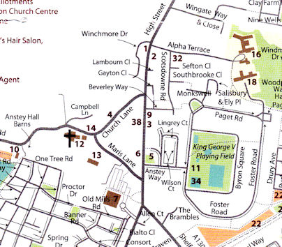
This paper is an overview of the evolution of Trumpington village, from c. 900 AD to the present. It is an extended version of a talk given to the Local History Group on 31 October 2024.
The focus of the paper is on the village rather than the overall parish. The geographic area is north-south along the High Street from Milestone 2 (just north of Wingate Way) to the Hauxton Road/Shelford Road junction and west-east from Anstey Hall Farm to east of the High Street.
In preparing the paper, I have referred to a number of sources, including the Royal Commission on Historical Monuments volume on Cambridge (1959); multiple volumes of the Victoria History of the Counties of England, including Thriplow Hundred with a chapter on Trumpington (1982a and 1982b); and the Trumpington Conservation Area Appraisal (2010). In the following sections, I have cited these as RCHME, VCH and Conservation Area Appraisal. See the Acknowledgements and References.
This is a work in progress. If you can help with corrections or additional information, please let us know. If you live in any of the older properties in the village and can help pin down the date they were built and whether there was an earlier building on the site, that would be very interesting.
Structure of the paper:
nucleated villages;
outline of Trumpington’s origins and growth;
timeline (c. 900-1100, 1100-1600, 1601-1800, 1801-1900 and 1901-present).
B. Nucleated villages
Dispersed farming communities, c. 4000 BC to c. 900 AD
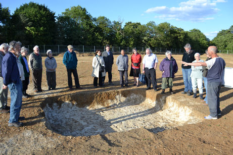
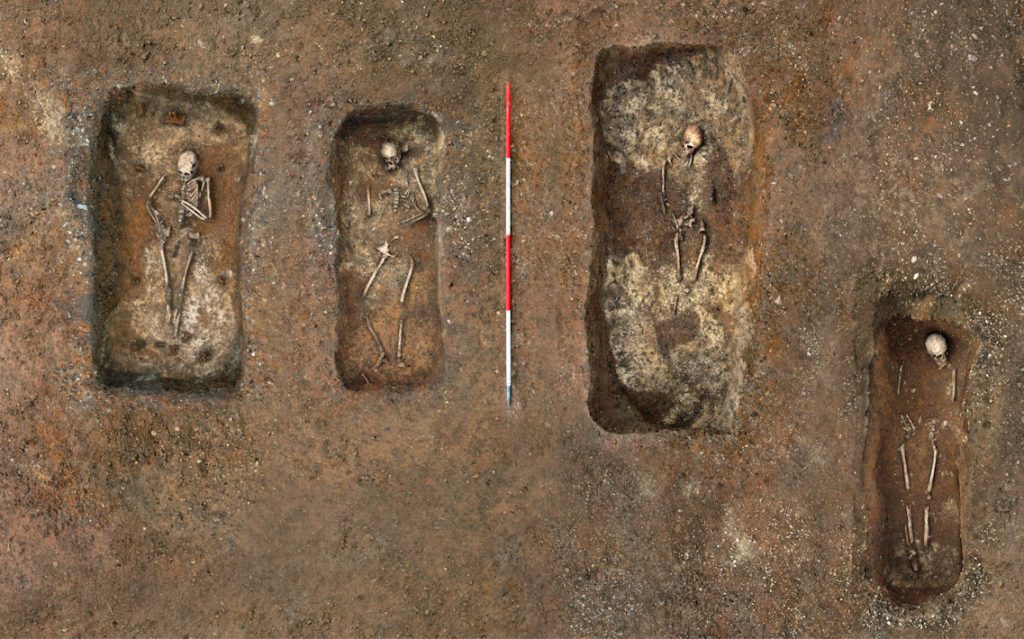
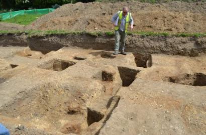
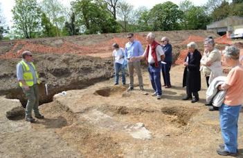
There were dispersed farming communities across our area for well over 4000 years up to about 900 AD. As we have heard in our meetings about archaeological excavations, this was far from an empty landscape. In the Anglo-Saxon period from around 600 AD to 700 AD, there was a small settlement in the area to the south west of the current church, with the remains of buildings and burials. There is no evidence of direct continuity between this Anglo-Saxon settlement and the current village but this can be thought of as the precursor to Trumpington village (Evans, Lucy and Patten, 2018).
Nucleated vs. Dispersed Settlements, c. 750-1200 AD
From around 750 AD, the settlement pattern across England evolved into areas that were dominated by either nucleated villages or dispersed villages. The nucleated village zone is called the Central Province or Region while the dispersed village zone is called the Ancient Region. Cambridgeshire is on the south eastern edge of the Central Province (Oosthuizen, 2007, p. 168).
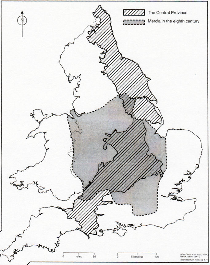
South Cambridgeshire Transition Zone
South Cambridgeshire was a transition zone on the outer edge of the Central Province. Communities were energetic and innovative in remodelling their places (Professor Carenza Lewis in a lecture about the archaeology of villages, Cambridge Antiquarian Society, March 2025). Trumpington and nearby parishes became characterised by a settlement pattern of a single newly-developed nucleated village surrounded by common fields (open field system). Neighbouring counties to the south including Essex and Hertfordshire were predominantly made up of dispersed hamlets and farmsteads (Roberts, 1987; Roberts and Wrathmell, 2000; Roberts and Wrathmell, 2002; Taylor, 1973, p. 54; Taylor, 1983, p. 125-30; Taylor, 2002, p. 53-71).
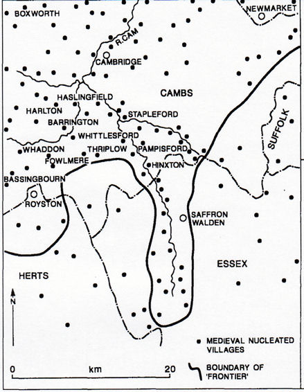
Counties, Hundreds and Parishes
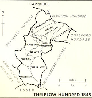
Also in this period, the administrative boundaries within Cambridgeshire became stabilised, with the county divided into Hundreds and Parishes. Trumpington parish is in the north of Thriplow Hundred and each of the villages in the Hundred became nucleated (VCH, 1982a, p. 153).
Scope of a Nucleated Village
There are a number of elements that make up a typical nucleated village (Roberts and Wrathmell, 2000; Roberts and Wrathmell, 2002; Taylor, 1983) and we will come across most of these elements in Trumpington:
Church, village cross
Village green, pond and other communal spaces, stocks and lock up
One or more manors, with manor houses
Homes
Public houses, shops, crafts and traders
Farms and farmhouses, linked to agricultural fields
Internal road network (linear and/or around a village green), plus road and footpath links beyond the village
Fresh water
Single or polyfocal settlement
A nucleated village may have evolved with a single focus or become polyfocal, with two or more centres. Factors favouring a polyfocal evolution included development from a dispersed settlement; organic growth; planned additions; and different ownership, land tenure or social grouping (Taylor, 1977). A local example of a polyfocal village was Great Shelford which had a very large green with settlement along the green edge (Professor Carenza Lewis in a lecture about the archaeology of villages, Cambridge Antiquarian Society, March 2025). The evidence discussed below shows that Trumpington was also a polyfocal village.
Location and connections
Local villages are typically close to the river and a river crossing, with good examples in Great Shelford and Little Shelford and Whittlesford (Taylor, 1971; Taylor, 1979, p. 106-111; Taylor, 1982, p. 25; Taylor, 1983; Taylor, 1989; Taylor, 2002, p. 57). Trumpington is on a ridge above the river, near an important crossing point to Grantchester. Grantchester itself evolved along the road from the ford (Taylor, 1979, p. 126-27). Villages depended on a network of roads and footpaths to nearby villages and further afield. They had surrounding agricultural fields, with an open field system, and shared pasture and meadows.
Influences Behind the Development of Nucleated Villages
A number of factors influenced the development of nucleated villages (Roberts, 1987, p. 212; Taylor, 1983, p. 112-24, p. 131; Williamson, 2003, p. 6-21). There were major changes in land ownership from the 900s, including the development of religious power and ecclesiastical estates. After the Norman invasion in 1066, there was a complete reallocation of land away from the church and from former leaders to new leaders and the growth of manorial estates. There were changes to agricultural practice, including the growth in the use of open fields, and the role of workers (Muir, 2000, p. 20507; Oosthuizen, 2010a; Oosthuizen, 2010b; Roberts and Wrathmell, 2002, p. 65-68; Taylor, 2002, p. 55). There was also economic development and population growth in the centuries up to the Black Death in the 1300s.
C. Outline of the origins and growth of Trumpington village
Starting point of village development, c. 900 – 1100 AD

I have already referred to the archaeological evidence of a community from 600 AD to 700 AD. From around 800 AD, there was a new phase of settlement to the south west and south east of the current church, with evidence from the excavations on the Waitrose site, Trumpington Meadows and Anstey Hall Barns. The excavation at Anstey Hall Barns identified a settlement and industrial area. There may have been a large barn which could suggest continuity with the later Anstey Hall Farm. There may also have been a north-south road close to the current boundary of the church and the grounds of Anstey Hall. The evidence will be reassessed when the report is published on the excavation at Anstey Hall Barns.
As in a number of other local villages, Trumpington probably developed at the crossing point of two or more roads, which was effectively exploited by its landowners. One of the main north-south roads from Kings Lynn and Cambridge to London passed through Trumpington. There was also an east-west route between Grantchester and Great Chesterford, with a ford and later a bridge over the River Cam.
Trumpington is first recorded in around 991 when a manor was bequeathed to Ely Abbey (Carr, 1973, p. 11; VCH, 1982b, p. 251). The church’s foundation (or re-foundation, given the burials in the 600s) could date from then, as Ely Abbey had a practice of establishing parish churches. The parish and village name of ‘Trumpington/Trumpintune’ was in use by 1050 and may be derived from ‘Trump’s farm’. Trumpington is one of a number of local parishes with ‘ton/tūn’ as the suffix, thought to indicate a unit established in the 700s or later during the break up of large estates (Kirby and Oosthuizen, 2000, maps 26 and 31; Reaney, 1943, p. 91).
Early layout, c. 1100 – 1600

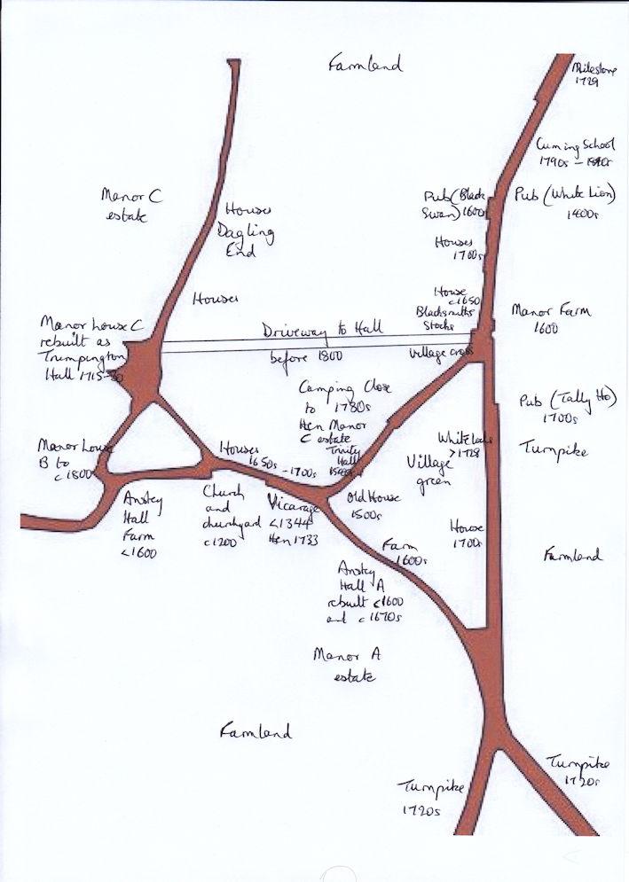
In analysing the development of the nucleated village from around 1100 AD, we have the physical evidence of the road pattern, the location of the church and churchyard, the site of the village cross and village green, and the locations of halls, homes and public houses.
The road pattern includes the triangle of roads (now Church Lane, Maris Lane and the High Street) plus their extensions north-south and east-west. We are unsure whether the eastern arm of the village green triangle is an early route or one that developed later (High Street). It is also possible that there was a second north-south route from the area around the church to and from Cambridge.
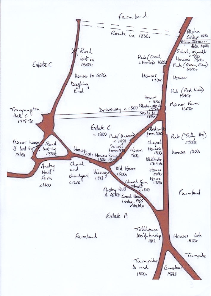
The evolution of the village may have been polyfocal, with three centres.
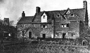
The initial focus was probably at the western end of the village green triangle, around the church and churchyard. Following the Norman Conquest, there were two manor houses and estates in this area. One manor house was on the site of Anstey Hall (A), and another manor house was between the church and the site of the current Trumpington Hall (B).
It seems likely that the area around the current Trumpington Hall became a second focus, including the manor house, estate, farmland and houses called Dagling End or Dagnell End (C).
Jo Sear discussed the evolution of Trumpington’s manors in her talk in February 2025. As in most of south Cambridgeshire, these manors were in the control of minor gentlemen (Evans and Rose, 2000, pp. xxx; Spufford, 1974, p. 28).
By the 1400s, there was a third focus around ‘Cross Hill’ and from there along the ‘northern’ part of the north-south main road. There was probably a village green within the triangle and in the area to the north west of the triangle which was called Camping Close. There would have been community facilities on the edge of the green, including the village cross, stocks and blacksmith. The north-south road was the highway from King’s Lynn and Cambridge to London and the inns on the route would have been an important part of the local community.
Changes to layout, c. 1601 – 1900
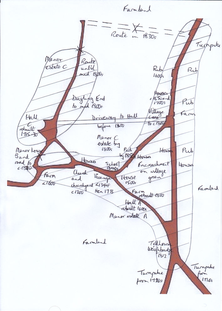
From the 1600s, there was gradual encroachment onto the village green. The northwest part of the green, Camping Close, was in private hands by the 1600s. The western north-south road and Dagling End were incorporated within Trumpington Hall estate in the 1800s. The triangular village green was gradually developed but was still not fully built up in the 1800s. There were few buildings along the ‘southern’ part of the High Street (the eastern side of the triangle), with much of the land still undeveloped or farmland at Inclosure in the early 1800s.
The north-south route along the High Street plus Hauxton Road and Shelford Road were developed as turnpikes from the 1720s.
During the Inclosure process in 1804-09, parcels of land were awarded to residents within the village, particularly along the High Street. By this point, the manor grounds were acting as barriers to development to the north, west and south of the local roads. After Inclosure, Anstey Hall (A) land ownership extended from Maris Lane to the south. Trumpington Hall (C) land ownership extended to the west and the north and to the east of the High Street. The land ownership of the third manor (B) probably extended to the west and east and the manor house and land had already been incorporated into the Trumpington Hall estate.
D. Fuller timeline
I will now consider the evolution of the village in more detail, focusing on the key developments. This includes the growth pattern and references to the main properties, with a note of evidence for their earliest date and construction.
c. 900-1100 AD
The Anstey Hall Barns excavation found evidence of continuity from the late Anglo-Saxon settlement into the Medieval period.
Domesday Trumpington: 1066 and 1086
William the Conqueror’s Domesday survey recorded land ownership at the time of the Norman invasion in 1066 and after the reorganisation of the country in 1086. It provides evidence of multiple land holdings in the parish, with 37 households in 1086 (about 185 people including 33 peasants and 4 slaves). (Domesday evidence from sources including Morris, 1981; The National Archives, Interpreting Domesday; and VCH, 1938, p. 414.)
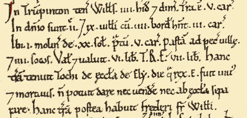
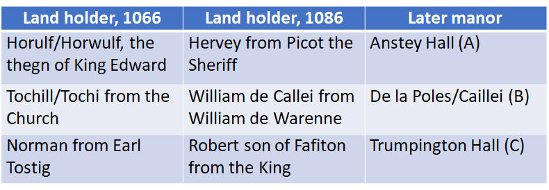
Domesday manors in Trumpington: 1066 and 1086
For Trumpington parish, there were five land holdings described in the Domesday Survey, three of which correlate with what we know of the later manors that were centred in the village (VCH, 1982b, p. 251-57). As in most of south Cambridgeshire, these manors were in the control of minor gentlemen. The Anstey Hall land (A) was held by Horulf or Horwulf, the thegn of King Edward, in 1066; and by Hervey on behalf of Picot, the Sheriff of Cambridge, in 1086. The second manor (B) probably included the land that was bequeathed to Ely Abbey by Ealdorman Beorhtnoth in the 990s. It was held by Tochill or Tochi from the Abbot of Ely in 1066, after which it was seized by Frederick de Warenne and held by William de Callei in 1086. The third manor (C) was held by Norman under Earl Tostig in 1066 and had been awarded to Robert, the son of Fafiton, by 1086.
Development from 1100-1600
Moving forward to the period from 1100 to 1600.
1100-1600: Parish Church and Churchyard
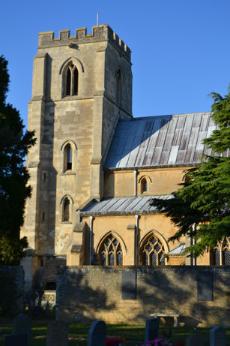
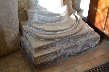
The core structure of the current Parish Church dates from the early 1200s, when it probably belonged to the Cailleis (Manor B), who retained the advowson of the rectory until the 1300s. The lower courses of the tower, the west walls of the aisle and the bases of two pillars date from the 1200s. In the early 1300s, the de Trumpington’s (Manor C) invested heavily in the church, including rebuilding the nave and creating an elaborate tomb and memorial brass, demonstrating that they were a wealthy family with a strong local connection (Ambrose, 2006; Conservation Area Appraisal, 2010, p. 19; Evans and Rose, 2000, p. xxx; RCHME, 1959, p. 294-98; Pevsner, 1970, p. 472-74; Spittle, 1970; Spufford, 1974, p. 28; VCH, 1982b, p. 262-65). The churchyard surrounds the church, with an extension to the south added in 1991. There is further information in the Timeline and pages about the history of the church. Jo Sear discussed the role of the church in society at our meeting in November 2023.
1100-1600: Farms and farmland
There is evidence of a number of farmhouses within the village, with references to Stokton Farm (Church Lane) in the 1400s and 1500s (VCH, 1982b, p. 260) and parts of Anstey Hall Farm dating from before 1600 (Fairbairn, 2015, p. 26), and it is probable that others farms which we know of from later centuries were also in operation (VCH, 1982b, p. 259-60). Farmland extended from the village centre to the rest of the parish, with three arable fields which the manors seem to have worked together in a triennial rotation by the 1380s: Cambridge Field to the north, Moor Field to the east, and Hauxton Field and South Croft to the south (Oosthuisen, 2010a; VCH, 1982b, p. 257-61).
1100-1600: Population change and impact on the village
The population density continued to increase until the late 1200s, declined in the 1300s when the area was badly affected by the Black Death, but recovered again from the 1500s (VCH, 1982b, p. 249). Climate change including cooler and wetter conditions is also thought to have had an impact on agriculture and the size of the population in East Anglia in the 1300s (Perry, 2013). The overall effect of the plague and climate change may have been a decrease in population of between 40% and 60%. Although we have no evidence to show the impact of a smaller population, this must have had an effect on the village, possibly with fewer houses being occupied and going into disuse before a later recovery. There is further information in the Timeline.
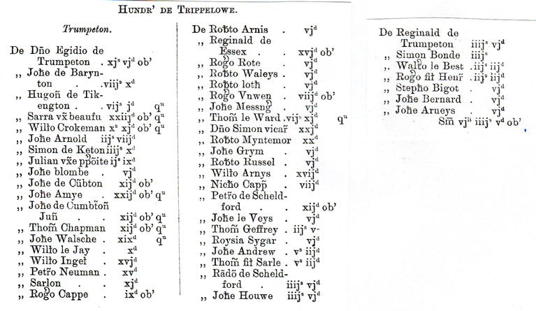
In 1327, the Lay Subsidy tax was levied by the Crown on the value of moveable goods (farm equipment, large domestic animals, surplus crops, etc.). It listed every taxpayer by name and the amount payable. The list for Trumpington parish had 48 taxpayers, including Egidio de Trumpeton, Johe Arnold and Thomas Chapman (Glassock, 1975, p. 26-27).
1100-1600: Community resources
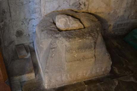
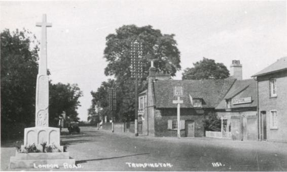
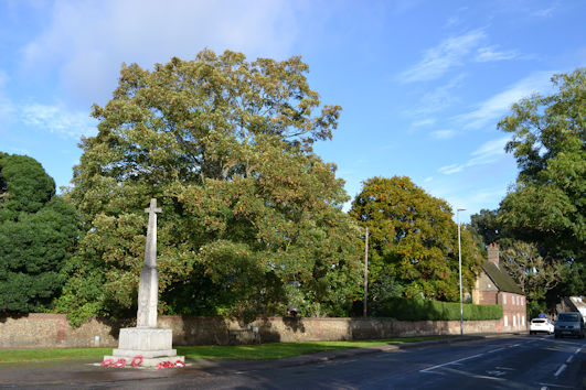
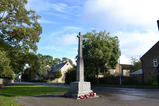
We have evidence that the village cross was erected at the junction of the High Street and Church Lane in around 1476 (RCHME, 1959, p. 296; VCH, 1982b, p. 251). The stone base of the cross had a socket for a wooden shaft and the Latin inscription “Pray for the souls of John Stokton and of Agnes his wife” and John Stokton had died before 1476. The location was still known as ‘Cross Hill’ in the early 1900s, even though the cross had been lost for at least 100 years. The base of the cross was rediscovered when the War Memorial was erected in 1921 and is now in the Church. See the Timeline.
We assume that the cross was on the edge of the village green (VCH, 1982, p. 249). There may also have been a village pond nearby, with Percy Robinson writing in the 1920s that this was probably situated near the north-west corner of the Unicorn garden, saying “I have been informed by old residents that there was a pond on this spot”, although there is no evidence of this on the Inclosure maps. In addition to the possible pond, we know that there were a number of wells within the village, including in the grounds of properties on Church Lane and the grounds of Anstey Hall. There was also an area known as Camping Close to the west of the cross (VCH, 1982b, p. 249). The game of camping or camp-ball, a blend of football and handball, was played throughout East Anglia (Dymond, 1990).
There is evidence of an annual fair or feast within the village, presumably held on the village green in this period: in 1314, Sir Giles of Trumpington was granted permission for a three-day fair starting on 1 August (VCH, 1982b, p. 251).
There was no market in Trumpington, but nearby Cambridge had a market and significant fairs including Stourbridge Fair. Cambridge would have been an important influence on the village, with its population, religious organisations and university driving the local economy.
We also have evidence of a guildhall but have not traced where this was located. In 1505, John Gardener’s will allocated 4d for the repair of the highway to the guildhall.
1100-1600: Roads and buildings
The road pattern within the village will have been well established in the Medieval period (VCH, 1982b, p. 249), including the north-south and east-west routes. The main road from Cambridge to London was maintained from 1584 by a bequest from Henry Harvey, the Master of Trinity Hall (Cambridge City Council, 2012, p. 8). We are unsure whether the eastern arm of the village green triangle was part of this route or added at a later date.
1100-1600: Grantchester Road and Church Lane
Grantchester Road was part of the route to the ford to Grantchester, with a cluster of buildings including Anstey Hall Farm, the Church and Caillei Manor. The church building dates from c. 1200 (see above), with Rectors and Vicars named from 1220. The church continued to be developed in the 1300s and ongoing in 1400s and 1500s. There was a Close just to the east of the church, with a house for the vicar, parsonage and tithe barn (VCH, 1982b, p. 263). Caillei Manor (B) was owned by the De la Poles from 1372 (VCH, 1982b, p. 252). Edmund de la Pole rebuilt the manor house and had a license to build an oratory there. It was the primary manor into the 1500s (VCH, 1982b, p. 261).
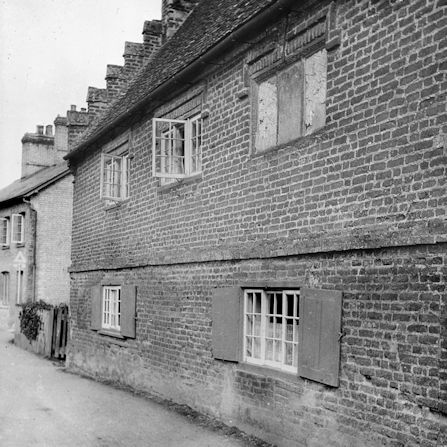
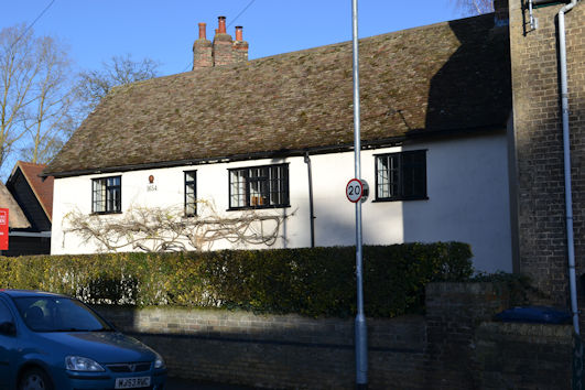
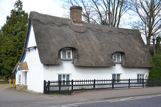
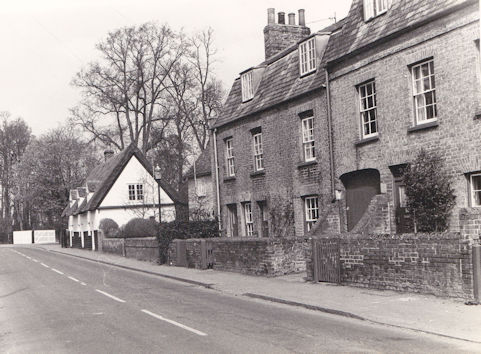
John Gardener’s will of 1505 allocated 20s to the ‘mendyng of the high wey fro the said gate [Pamentes gate] unto Stokton crosse’ (repairing the highway from the church gate to Stokton Cross). Buildings along the road are thought to have included Stokton Farm, with the farm recorded as 100 acres in the 1500s. The farm house may have been on the north west side of Church Lane. There was a property owned by Trinity Hall on the site now occupied by the Lord Byron pub (historically the Unicorn pub), with deeds at Trinity Hall showing the building going back to at least the 1540s. The home called The Old House at the junction of Church Lane and Maris Lane dates from the late 1500s, with narrow red bricks and crow-stepped gables (VCH, 1982b, p. 249).
1100-1600: Trumpington Hall and Dagling End
The manor house that became Trumpington Hall (C) was a short distance to the north of Caillei Manor, with the manor house referred to from 1280s (RCHME, 1959; VCH, 1982b, p. 254). There were houses to the east of the manor house in the area called Dagling End. John Gardener’s will allocated 34s 4d to maintain the road from the church to Dagling End and in 1521 John Cotton gave five quarters of barley, probably to maintain the same route.
1100-1600: Maris Lane
Maris Lane would have been dominated by the precursor to Anstey Hall (A). The earliest evidence of a manor house at this location is a reference in 1279 (Carr, 1973, p. 16; VCH, 1982b, p. 252).
1100-1600: High Street
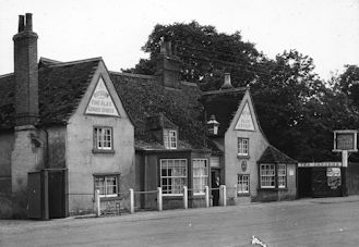
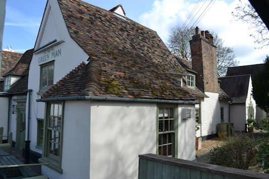
On the east side of the High Street, the Green Man pub is the oldest surviving house in the village, a timber-framed hall-house, built in the 1400s with ground floor hall open to the roof in the middle and cross-wing at each end, recorded as the White Lion pub in 1667 and 1764 (Conservation Area Appraisal, 2010, p. 6 and 14; RCHM, 1959, p. 390; VCH, 1982b, p. 250).

There was also a pub known as the Ram’s Head, which probably stood on the High Street. The date of origin is unknown but it was recorded as being owned by Edward Pychard in 1547 and was also noted in 1657 (VCH, 1982b, p. 250).
Development from 1601-1800
Moving on to the period from 1601 to 1800, in many ways the layout of the village remained unchanged, although more properties were established along the roads.
1601-1800: Hearth Tax, 1664
The Hearth Tax was one of the main sources of government revenue during the reigns of Charles II and James II, with four Acts in force from 1662 to 1689 (Schurer and Arkell, 1992). Hearths were an obvious target for the government, as chimney stacks could be identified from the outside of buildings and the installation of fireplaces and chimneys had become fashionable in larger houses and hearths and chimneys were also common in more basic houses (Hay, 2006, p. 3).
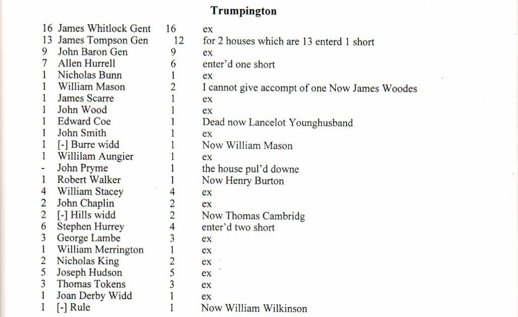
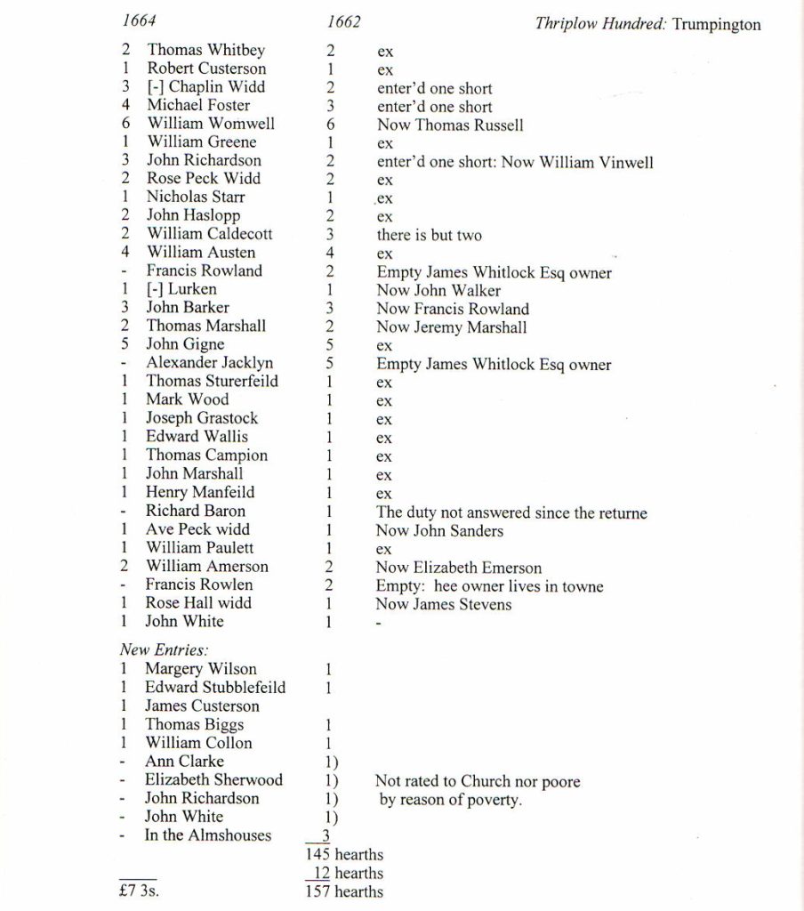
We have a good summary of the parish in the Michaelmas 1664 Hearth Tax returns, when there were 67 entries for properties, the majority of which would have been in the village. The table lists the owners of properties and the number of hearths, with column 1, hearths 1664; column 2, householders, 1662; column 3: hearths, 1662; column 4: notes (Evans and Rose, 2000, p. 305-06).
1601-1800: Relationship between Hearth Tax, Parish Officers and Roles in Society, 1660s
We also have information about society in the 1660s in the Parish Church’s Vestry Audit Book, with detailed information about parish officers (Cambridgeshire Family History Society, 2002). There is a close correlation between the number of hearths in a property and the level of involvement of the occupant in the parish offices. Very few of the 1-2 hearth householders had an involvement in the management of the parish. There was a middle group of people in 3-4 hearth households who probably had an agricultural or trade role and an active part in parish affairs, one of whom left a bequest which led to the foundation of the first local school. There were landowners and businessmen with substantial properties with 5 or more hearths and a major role in the parish: the three householders with the highest number of hearths were the leaders of local society, manor owners and gentlemen, while two householders with 5 hearths were innkeepers. These groupings demonstrate that the social structure and economic base of Trumpington was already diverse.
Using the information in the Hearth Tax and the Vestry Audit Book, we can identify a number of specific properties and the parish offices of their occupants in one or more years in the 1650s and 1660s.
Manor houses:
- Anstey Hall Manor, James Thompson Gent. (Manor A, 13 hearths)
- De la Poles Manor, John Baron Gent. (c. 1659) (Manor B, 9 hearths)
- Trumpington Hall Manor, James Whitelocke Gent. (1662) (Manor C, 16 hearths)
Public houses:
- White Lion, John Gifford [Gigne]: 5 hearths
- Black Swan, Joseph Hudson: 5 hearths
Individuals
- Vicar: Benjamin Southwood (thought to have been in post from 1654 to 1663); Edward Sterne (from 1663 to 1669)
- Churchwarden, including William Anger (1665); William Austin (1666); William Emerson (1665); Joseh Hudson (1662, 1664, 1667); Frances Rowny (1665); Thomas Russell (1665); John Smith (1662, 1663); John Wilson (1662, 1667)
- Surveyor of the Highways, including William Anger (1666); John Baron (1663, 1664, 1665); Allen Hurrell (1663, 1664); James Thomson Gent. (1664); James Whitelock Gent. (1664, 1665); John Wilson (1666)
- Overseer of the Highways, including Thomas Cambridg (1667); John Gifford (1667)
- Overseer of the Poor, including William Caldecott (1663); Stephen Hurrey (1664); George Lambe (1664, 1665); Nicholas Nunn (1667); John Sanders (1663-1666); Nicholas Scare (1664, 1667); William Stacey (1666)
- Constable, including Richard Baron (1662); John Chaplin (1665, 1666); William Emerson (1662, 1664); John Smith (1665, 1666)
- Petty Constable, including Allen Hurrell (1664); William Stacey (1663, 1664)
- Innkeeper, including John Gifford (1667); William Umwell/Womwell (1664)
- Common Herdsman, William Greene (1667, 1669); John Richardson (1669)
1601-1800: Main Characteristics of the Village Pre-Inclosure
Howard Slatter talked about the village in the late 1700s and the 1800s in October 2022. In the 1720s, the two turnpike roads were designated, which confirmed the importance of the High Street (VCH, 1948, p. 85). The turnpikes divided on the south side of the village, with Hauxton Road on the route of the Cambridge-Fowlmere turnpike and Shelford Road on the route of the Cambridge-Great Chesterford turnpike. By the late 1700s, Trumpington Hall and Anstey Hall estates were dominant, with the De la Poles Manor incorporated in the Trumpington Hall estate from 1785. The majority of properties were along the High Street, Grantchester Road, Church Lane and Dagling End, with buildings on the road frontages. The land within the village green triangle was divided into a few properties, most with extensive land: there were 4 properties off Church Lane, 2 of which had land extending to the High Street (so with Church Lane as the dominant frontage); 3 or 4 properties off the High Street; and 1 property off Maris Lane.
1601-1800: Individual streets
1601-1800: Grantchester Road
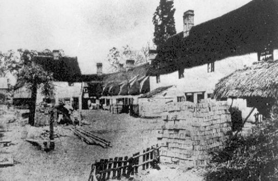
Anstey Hall Farm developed during this period, including the farm house and the timber-framed threshing barn and dovecote, incorporated into the Anstey Hall Barns housing development in the 2010s (Conservation Area Appraisal, p. 33-34; VCH, 1982b, p. 256).
The Parish Church continued to be at the heart of the village. The ‘vicarage’ had 5 or 6 hearths in c. 1670 (VCH, 1982b, p. 263). There were ongoing disputes between the church and the Thompson’s (Anstey Hall, A), about the boundaries of the church close and rights of access to the tithe barn. As a result, in c. 1733, the newly-appointed Vicar, John Barnwell, pulled down the old vicarage and rebuilt the rectory as a new vicarage, with an ancillary gault brick building (now the Bakehouse, renovated in 2010) (Conservation Area Appraisal, 2010, p. 18, 33; RCHME, 1959, p. 388; VCH, 1982b, p. 263). (The vicarage became a private house in 2009.) The churchyard wall along Grantchester Road is dated to the 1600s-1700s, red brick capped with a stone coping (Conservation Area Appraisal, 2010, p. 33).
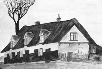
A number of houses opposite the church along Grantchester Road were built in this period. Numbers 20-22 are from the late 1600s to early 1700s, timber framed with a thatched roof (Conservation Area Appraisal, p. 18, 34). Numbers 16-18, dated to 1654, are timber framed, rendered with a tiled roof set back from road, known as Dated Cottages, with a fire plate on the wall (Conservation Area Appraisal, 2010, p. 18, 34; RCHME, 1959, p. 389).
There were two roads branching off Grantchester Road opposite Anstey Hall Farm and the Church, giving access to De la Poles Manor (B) and Trumpington Hall (C), shown on the Inclosure maps. In a major change to the village, De la Poles Manor and its estate was purchased by the Pembertons around 1784-85 and incorporated into the Trumpington Hall estate, with the manor house demolished after 1800 (VCH, 1982b, p. 252).
1601-1800: Trumpington Hall, Dagling End and Church Lane
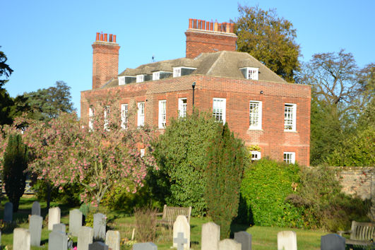
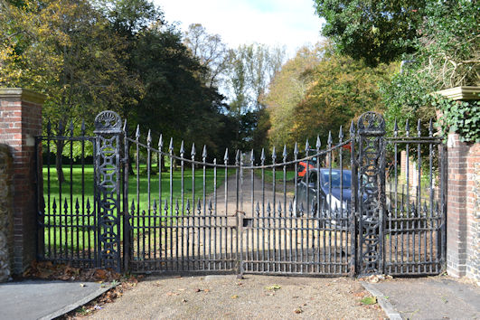
Trumpington Hall and Manor was purchased by Sir Francis Pemberton in 1675 and the current hall was built on the site of the manor house in 1715-30 (Conservation Area Appraisal, 2010, p. 33; Pevsner, 1970, p. 474; VCH, 1982b, p. 253). The hall has a forecourt screen, gate piers and gates, dating from c. 1710 (Conservation Area Appraisal, 2010, p. 33).
There were a number of houses in Dagling End, on the east side of the track from the turnpike to the Church, east and north east of Trumpington Hall. Camping Close was in private hands by the late 1600s. In 1681, Thomas Allen gave the 9-acre Camping Close for apprenticing poor boys. The land was initially let to John Baron, the owner of the De la Poles Manor and the lease later passed to the Pembertons (VCH, 1982b, p. 267). Trumpington Hall incorporated Camping Close into the parkland of the Hall after 1785 (VCH, 1982b, 249) and the driveway between the Hall and the High Street was in place by 1800, with a brick and flint wall along Church Lane to delimit the Hall’s grounds.
1601-1800: Maris Lane
Anstey Hall was rebuilt around 1600 and again in the 1670s, then re-cased in red brick c. 1685 (Conservation Area Appraisal, 2010, p. 19; Pevsner, 1970, p. 474). It was inherited by Christopher Anstey in 1748 (VCH, 1982b, p. 255). The gateway also dates from the 1700s (Conservation Area Appraisal, 2010, p. 19, 35).
The original Church Farmhouse is thought to have been an early 1600s timber framed baffle entry house (replaced by the current house c. 1800). The farm buildings and farmyard presumably extended along Maris Lane to the High Street.
1601-1800: High Street, west side, north to south
We now have more evidence of properties along the High Street. The pub on the west side of the road, 18 and 20 High Street, was first called the Black Swan (later the Coach and Horses, now the Sole and Duck). The original two storey building, dating from the early 1600s, was timber-framed and plastered, with a tiled roof, remodelled in the 1700s. It was leased to Thomas Hide from the 1770s (Conservation Area Appraisal, 2010, p. 9, 14, 34).
Immediately south of the pub, houses number 22, 24, 26 date from the 1700s, red brick with thatched roof (Conservation Area Appraisal, 2010, p. 15). Numbers 28 and 30 are c. 1650, red brick, extended and reroofed in the 1700s (Conservation Area Appraisal, 2010, p. 15).
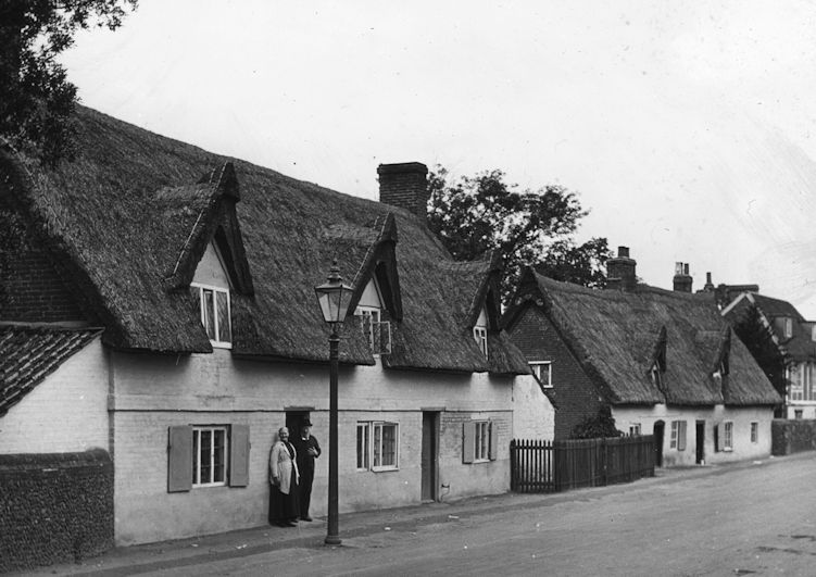
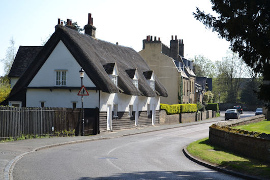
The Cross Hill area included the village cross, a blacksmith and the village stocks, all on the west side of the High Street. The upper structure of the village cross may have been removed before 1800, as it is not shown on the Inclosure maps. The Harradines were the village blacksmiths from the 1760s. The village stocks were in place into the 1850s, as remembered and drawn by Samuel Page Widnall in 1889.
There were still relatively few properties along the High Street on the east arm of the village green triangle, but in 1728 George Whitelocke left his house as a legacy to the poor of the village and this may be the house that was occupied by 3 women in 1728 and was used as the workhouse from 1780 (VCH, 1982b, p. 262, 267). Number 52 is an early 1700s timber framed and rendered house, thatched with a central chimney stack (Conservation Area Appraisal, 2010, p. 10, 15, 34).
1601-1800: High Street, east side from north to south
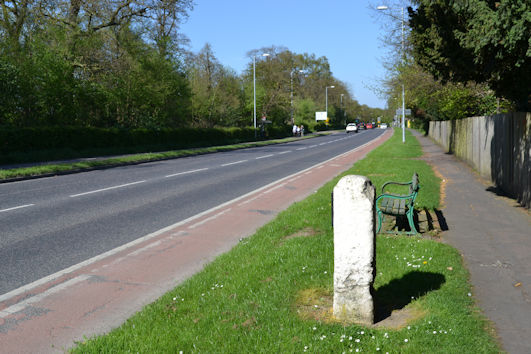
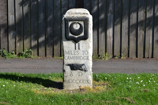
The second Trinity Hall milestone was erected in 1729. The current St Mary’s House, 47 High Street is on the site of a boarding school run by James Cuming and his son Charles from the 1790s-1840s. As noted above, the pub, 55 High Street, then known as the White Lion, was recorded in 1667 and 1764, later named the Green Man.
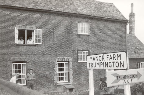
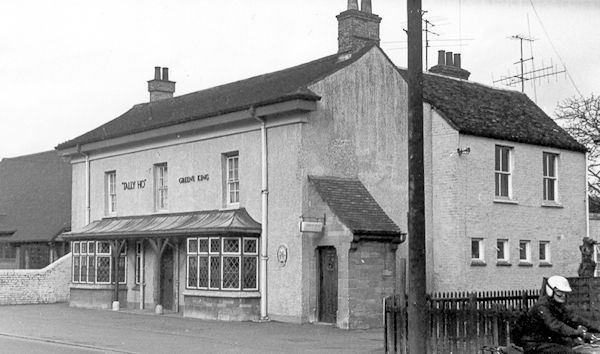
Manor Farm was an early 1600s farmhouse, also known as Witt’s Farm, demolished in 1969 (RCHME, 1959, p. 389-390). The core of the Tally Ho pub, a two-storey rendered building, is likely to date from the 1700s, now named the Hudson’s Ale House (Conservation Area Appraisal, 2010, p. 14).
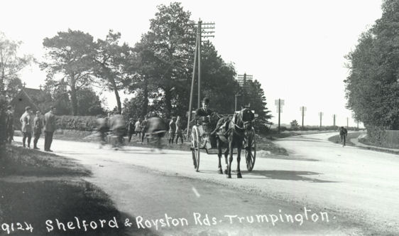
Hauxton Road and Shelford Road
Hauxton Road is on the route of the Cambridge-Fowlmere turnpike and Shelford Road is on the route of the Cambridge-Great Chesterford turnpike.
Development from 1801-1900
We have covered the development of the village from 1801 at previous meetings, including Howard Slatter’s talk about Trumpington from 1801 to 2001 given in October 2022.
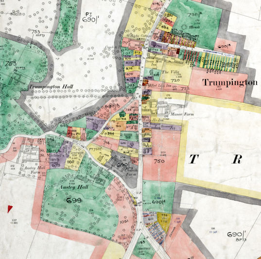
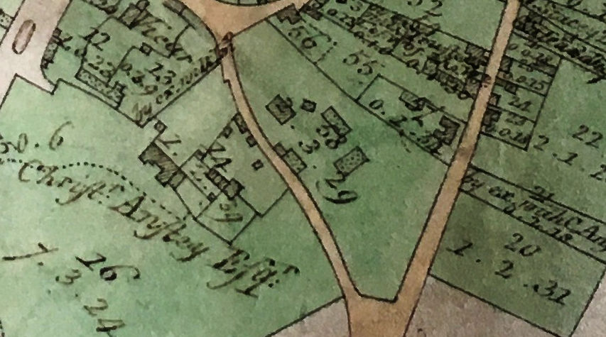
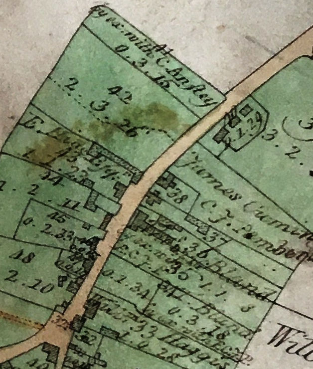
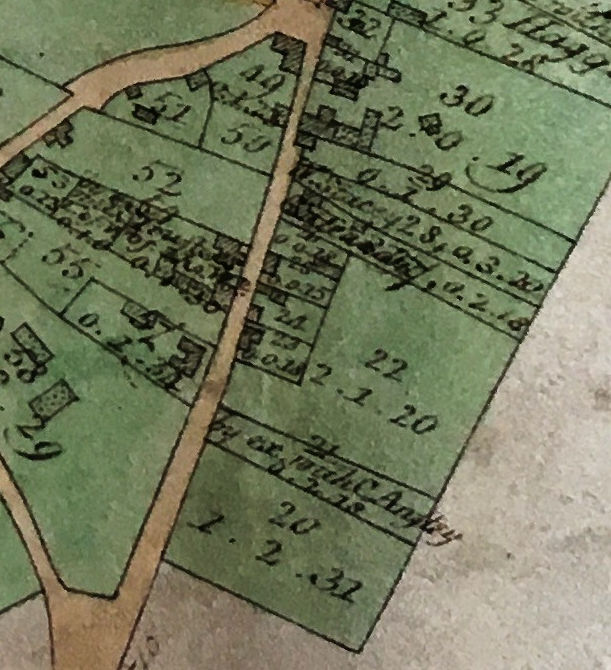
The Inclosure process took place from 1801 to 1809. By that point, almost all of the parish was owned by the Pembertons and the Ansteys, including their halls and estates and Manor Farm, Church Farm and Anstey Hall Farm within the village (VCH, 1982b, p. 257-61). In the process, a number of additional properties were allocated within the village and there were changes to the road pattern, including the stopping up of paths to and from Dagling End (Ginn and Co., 1801). There were awards to families including Haggis, Harradine, Bland and Cuming (VCH, 1982b, p. 260). When Baker published a map of Cambridge in 1830, there was an additional path from the High Street to Dagling End but that had been downgraded to a farm track by 1885.
There was limited growth of the village during the 1800s, other than rebuilding of houses and additional houses along Grantchester Road, Church Lane and the High Street, and the development of Alpha Terrace to the east of the High Street from the 1890s (VCH, 1982b, p. 249-50). The extent of rebuilding was significant: in 1876, the Pembertons were said to have rebuilt many of around 50 properties they owned in the village, from lath-and-plaster thatched cottages into grey brick houses, including examples on Grantchester Road (Anon., 1876, p. 4; VCH, 1982b, p. 249). The grounds of Trumpington Hall dominated the west side of the village from the early 1800s, with the houses in Dagling End being incorporated in the estate by the 1870s. The population of the parish increased from 494 in 1801 to 771 in 1851 and 960 in 1891, when there was growth beyond the village (VCH, 1982b, p. 249).
1801-1900: Individual streets
1801-1900: Grantchester Road
The Inclosure maps from the early 1800s included Anstey Hall Farm, the Church, Vicarage and 3 properties opposite the church (Inclosure map areas 16, 11, 12, 13, 64). The De la Poles Manor had been purchased by the Pembertons around 1785 but the hall and other buildings were still on the maps, as were the two roads branching off Grantchester Road giving access to De la Poles Manor and Trumpington Hall and Dagling End (Inclosure map areas 67, 68). The De la Poles hall and other buildings had been demolished by 1830 and the road in front of the house had been removed (not shown on Baker’s map). There was one property within the space opposite the Farm (Inclosure map area 66).
The Church was restored by William Butterfield in 1849 and 1854, culminating in a new roof installed in 1876 (VCH, 1982b, p. 265).
As noted above, numbers 20-22 and 16-18 Grantchester Road have survived from the 1600s and early 1700s. There were additional properties along Grantchester Road on the Inclosure map, which were replaced by the current properties (Inclosure map areas 61, 62, 63). Numbers 10 and 12-14 Grantchester Road date from the early 1800s, built of gault brick with slate mansard roof and carriage arch, which were used as a ‘Dame school’. Numbers 2-4 and 6-8 Grantchester Road are two sets of semi-detached houses built in gault brick with slated roofs dating from the 1800s and called Stokton Cottages, presumably honouring a connection to the Stokton family of the 1400s (Conservation Area Appraisal, 2010, p. 18).
1801-1900: Trumpington Hall, Dagling End and Church Lane
The Trumpington Hall estate extended from the river to the High Street by 1800, with a tree-lined driveway between the Hall and the High Street (Inclosure map areas 77-80, 65, 74-76, 81-84). The Inclosure map shows that there were at least 10 houses near the Hall in Dagling End (Inclosure map areas 86-94 and 85). The surrounding land and houses in Dagling End were incorporated into the estate grounds by 1870 (VCH, 1982b, p. 249), when the route to the north of the Hall was also lost, as was a route to the High Street shown on the 1830 map.
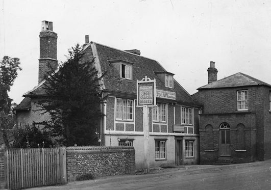
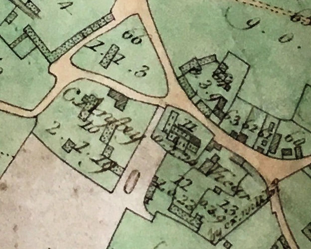
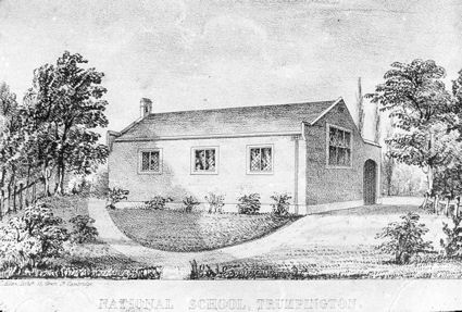
At Inclosure, there was a group of buildings on Church Lane, at the junction with Maris Lane and Grantchester Road (Inclosure map area 60). This land was purchased by the parish and Trinity College in 1842 and developed as the Church School which opened as a National School in 1843, white painted brick under tile roof, initially with 2 classrooms for 100 pupils, then an infants’ classroom was added in 1868 (VCH, 1982b, p. 266). There was an adjoining cottage used as the master’s house until the Schoolmaster’s House was built in 1858, a gault brick house with ornate gable end (Conservation Area Appraisal, 2010, p. 20-21; VCH, 1982b, p. 266). Also at Inclosure, there was a large property owned by Trinity Hall on Church Lane, probably the basis of The Unicorn (Lord Byron) pub, a beer house recorded from 1858 (Inclosure map area 59) (Conservation Area Appraisal, 2010, p. 20). In addition to The Old House, there 5 or 6 properties along the south east side of Church Lane, one or two of which had land extending to the High Street (Inclosure map areas 51-56). A number of the properties near The Old House were replaced by brick-built houses in the 1800s (Conservation Area Appraisal, 2010, p. 11).

1801-1900: Maris Lane
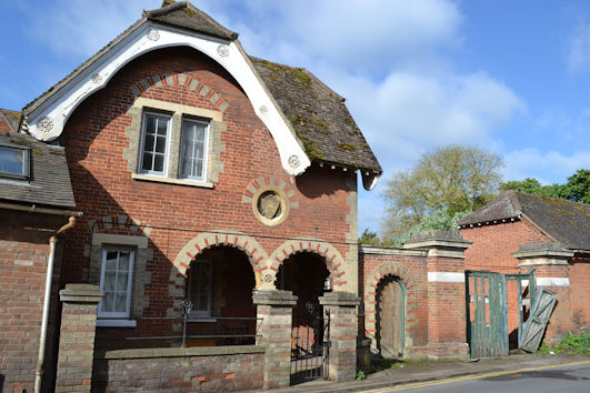
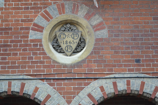
On the Inclosure maps, Anstey Hall is shown with a few outbuildings to the west of road and grounds to the rear (Inclosure map areas 14-16). Other buildings were added in the mid 1800s, including the Coach House, a Lodge with ornate Ruskinian Gothic details built in 1865 and a large range of redbrick stabling built in the 1860s (Conservation Area Appraisal, 2010, p. 11; VCH, 1982b, p. 255-56).
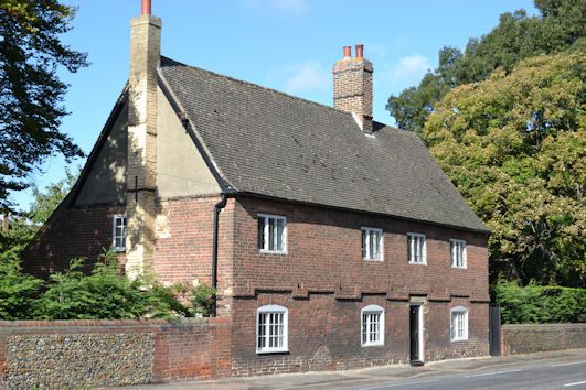
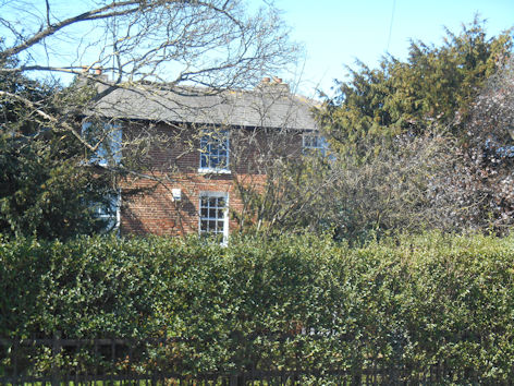
At Inclosure, the land on the other side of Maris Lane was one property, extending from Church Lane to the High Street, including the farm house and a few other farm buildings (Inclosure map area 58). The current Maris House or Church Farm House was built around 1800 on the site of the earlier house, red brick with tiled roof, built for the Maris family who were the tenant farmers of the land until the 1860s (Conservation Area Appraisal, 2010, p. 19, 34).
1801-1900: High Street, west side, north to south
On the Inclosure maps in the early 1800s, there were 6 or more properties on the west side of the High Street from the Black Swan to Cross Hill, a large space at Cross Hill with no evidence of a cross and only 3 or 4 properties from Cross Hill to the Maris Lane junction, with the former village green still partly undeveloped (Inclosure map areas 41-48).
The Black Swan was leased to John Mortlock in 1813, when it was known as the Coach & Horses (VCH, 1982b, p. 250). It has a brick west wing dating from the early 1800s (Conservation Area Appraisal, 2010, p. 14, 34). The pub was purchased by the Pembertons in 1851. The blacksmiths was on the High Street on the north west side of Cross Hill until the 1850s when it moved to the corner of the High Street and Church Lane and the earlier building was demolished. The village stocks were also there into the 1850s, as recorded by S.P. Widnall (1889). A lodge was built beside the driveway to Trumpington Hall, in red brick ‘cottage orne’ style (Conservation Area Appraisal, 2010, p. 9, 14).
At Inclosure, it is noticeable that there were only 4 or 5 buildings on the west side of the High Street between Cross Hill and Maris Lane (Inclosure map areas 49, 50, 54, 57). There was one building at the Cross Hill junction, presumably replaced 50 years later by the new blacksmiths. A number of houses were added through the 1800s. A Wesleyan Methodist chapel was built to the rear of 40 High Street in the 1870s (VCH, p. 266). The terrace of 42-46 High Street was built with gault brick under slate roofs. Whitlocks house and malting was reconstructed in 1819 and again in the late 1800s when the area was known as ‘Whitelock’s Yard’ or ‘Workhouse Yard’, where there were 20 cottages with over 100 people in 1861 (VCH, 1982b, p. 249). There was also Swan’s Yard, built by 1832, with further rows of cottages (VCH, 1982b, p. 249). The Red House, number 50 High Street, is a Georgian house built in red brick in the late 1700s or early 1800s. The land further to the south continued to be used by Church Farm through the 1800s.
At Inclosure, there were no properties to the south of Maris Lane on the west side of the High Street. The Tollhouse and Weighbridge, 60 and 62 High Street, were built around 1811-12 as part of the turnpike system, gault brick under a hipped slate roof with later extensions (Conservation Area Appraisal, 2010, p. 15, 34).
1801-1900: High Street, east side from north, and Alpha Terrace
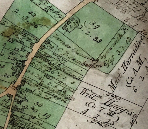
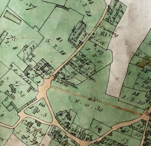
In the Inclosure award, land on the east side of the High Street between the milestone and the later route of Alpha Terrace was allocated to a number of individuals, with 3 existing buildings shown on the map (Inclosure map areas 39, 40). There were 4 properties between there and Cross Hill, including the Cuming school, the Green Man and Manor Farm (Inclosure map areas 33-38).
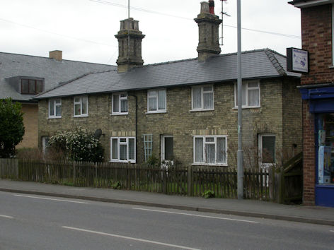
Alpha Cottage, 45 High Street, was built in grey gault brick in the early 1800s (Conservation Area Appraisal, 2010, p. 35). St Mary’s House, 47 High Street, was built as a detached period house on the site of the boarding school about 1880. As a major development of the village, Alpha Terrace was built between Alpha Cottage and St Mary’s House from the 1890s, including Victorian and Edwardian terrace houses and the Free Church, opened in 1899 (Conservation Area Appraisal, 2010, p. 26; VCH, 1982b, p. 250).
Numbers 49-51 High Street are Victorian gault brick buildings, used for a variety of shops. The Green Man was held by Thomas Bland at Inclosure and included land to rear. The nearby Red Lion pub opened by the 1840s (VCH, 1982b, p. 250). The farmhouse, buildings and land to the rear of Manor Farm were held by William Haggis at Inclosure.
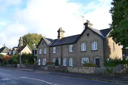
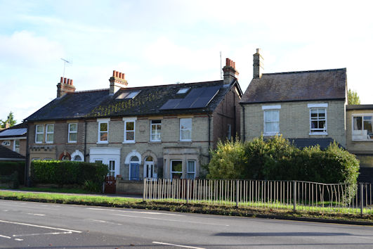
At Inclosure, there were still only 5 or 6 properties on the east side of the High Street between Cross Hill and the Hauxton Road and Shelford Road junction (Inclosure map areas 20-30). There was a regular north-south boundary some distance away from the road, marking the division between the village and farmland. The building that became the Tally Ho pub is shown on the Inclosure map and was first recorded as a beer house in the 1840s, with a plainer frontage. In the 1800s, a number of detached and semi-detached gault brick estate cottages were built at 79-93 High Street (Conservation Area Appraisal, 2010, p. 35). The land opposite Maris Lane continued to be farmed as part of Church Farm.
At Inclosure, there were two buildings owned by Anstey at the High Street and Shelford Road junction (Inclosure map areas 18-19). In the late 1800s, houses started to be built around the junction, including 109-119 High Street (Conservation Area Appraisal, 2010, p. 16). The land between Shelford Road and Hauxton Road was awarded to the Vicar at Inclosure (Inclosure map area 17) and later developed as the Extension Cemetery which opened in 1893, surrounded by tall pines, with and entrance lych gate and internal avenues of yew trees (Conservation Area Appraisal, 2010, p. 16, 22).
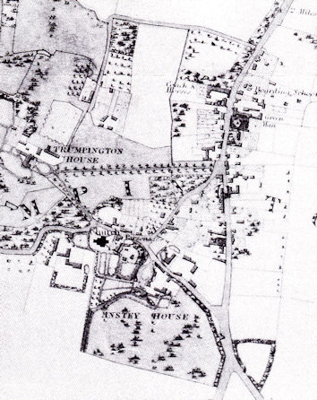
Development from 1901-present
We have covered this period in previous meetings, including Howard Slatter’s talk about Trumpington from 1801 to 2001 in October 2022. The starting point is the Land Value map from 1910, which shows that the village was largely unchanged since the early 1800s (VCH, 1982b, p. 250). There had been infill within the triangle but still limited development along the east side of the High Street and to the south of Maris Lane. There were still three farms within the village, with farmland extending to the east of the High Street and the eastern boundary to farmland still in place. There are 5 pubs marked on the High Street and Church Lane. The estates of Trumpington Hall and Anstey Hall dominate the west and south of the village. Alpha Terrace is now well developed to the north of the village.
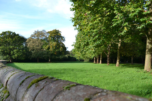
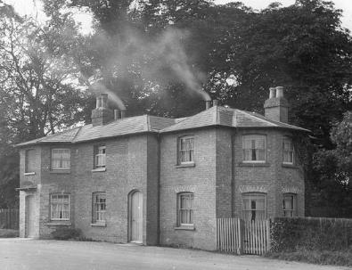
Today, of course, there have been major changes along the High Street and to the east and south, with infill and rebuilding and new side roads, including the estate built to the east of the High Street from the 1940s. Manor Farmhouse was demolished in the late 1960s and its land close to the village was developed for housing. Maris Farmhouse is still there but Church Farm itself ceased to be a working farm in the 1960s, with Bidwells and then housing filling the farmyard and the land. Anstey Hall and Anstey Hall Farm continued to be owned as a single unit until the late 1930s when the farmhouse and farmland being sold to Henry Parsons, the tenant farmer, with the farm also known as Tollers Farm and Parsons Farm. The land near the village continued in use as farmland and then the Plant Breeding Institute (PBI) until the 2000s but has now been developed. Anstey Hall itself and its outbuildings are relatively unchanged, although the setting has been encroached on by Waitrose. There were a number of changes of ownership and use up to 1941 when it was taken over by the Government and later sold to John de Bruyne in 1998. Trumpington Hall and its grounds are largely unchanged and have acted as a major influence on the growth of the village, protecting land from development between the High Street and river. They have become more secluded in recent decades. Partly because of Anstey Hall and Trumpington Hall, we have extensive areas of treescape within the village. Four of the 5 pubs are still active, although the Red Lion was rebuilt after a fire in 1914, rebuilt again in the 1930s and demolished in 1975. The Church School was replaced by Fawcett School in 1950.
1901-present: Church Lane
The Church School continued until 1950 when pupils transferred to Fawcett School. Trinity Hall sold The Unicorn to Dale’s in 1920 and it was renamed The Lord Byron in May 2012.
1901-present: Maris Lane
The estate around Anstey Hall was intact until the 1940s then continued as farmland until 2000s. It has now been developed as the Trumpington Meadows housing and country park, apart from the area immediately around the Hall. Maris Farm house is still in place but the farm yard and stackyard have been developed with office buildings for Trumpington Farm Company and others.
1901-present: High Street, west side
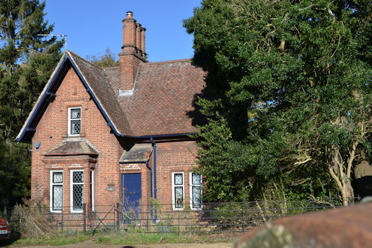
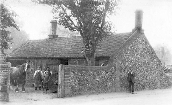
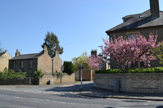
There have been frequent changes along the High Street. The Coach & Horses became the Wok ‘n’ Grill from c. 2005 to August 2020 when it was redeveloped as the Sole & Duck, October 2020. Around Cross Hill, the War Memorial was erected on the site of the village cross in 1921. The blacksmiths was replaced by a Bidwells building in 1985-86 (now Evelyn Partners), with Sloane Court to its south. Whitlocks was rebuilt in 1968 and again in 2006. The area towards Maris Lane included a wood-yard, cycle shop and village lock-up in the 1920s, replaced by the Shell Service Station garage and shops in 1957, plus Bidwells built in 1968, in brown brick with structural concrete banding and lead roof.
1901-present: High Street, east side
On the other side of the road, the Green Man was modernised in 1954. A house called The Villa was replaced by a petrol station which closed in 2012 and the land has been developed as houses. The Red Lion and Manor Farm and surrounding land were replaced by Lambourn Close, Gayton Close and Beverley Way in the 1960s and 1970s, with the track from the farmhouse to the agricultural fields to the east being used as the line of Beverley Way. The Village Hall was built in 1908 and extended to the rear in 1927 (Conservation Area Appraisal, p. 14, 35). The Tally Ho pub had bay windows and a porch roof added in about the 1930s. After two changes of name, it became the Hudson’s Ale House in February 2025. The Church Farm farmland extended to the east, with cows crossing the High Street to go to pasture in the 1920s. It became a recreation ground then shops and Anstey Way, built in the 1940s-50s on the line of a farm track to give access to the estate of houses and flats built from 1946 to 1948. The plot to the south became Crossway Nurseries in the 1920s, demolished and redeveloped in the early 1980s. One curiosity is 105-107 High Street, a pair of thatched roof cottages set back from the road, dating from the early 1900s.
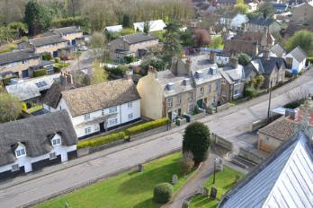
Despite the changes in recent decades, we are fortunate to still have an historic village centre, much of which would have been recognisable to previous generations.
Acknowledgements
I am grateful to previous researchers who have written about nucleated villages and the history of Trumpington, including Christopher Taylor, the Victoria County History authors, D.W. Lloyd (1951) and Edith Carr (1973). I have benefitted from advice from lecturers on Extra-Mural courses organised by the University at Madingley Hall, including Dr Susan Oosthuisen and Dr Jo Sear. I would also like to thank the other Committee members.
References
Ambrose, Tom (2006). St Mary & St Michael Trumpington. [Church guide]. [Trumpington: Parish Church.]
Anon. (1876). The Town and County, Trumpington. Cambridge Chronicle, 1 January 1876, p. 4.
Cambridge City Council. Planning Department (2010). Trumpington. Conservation Area Appraisal. Cambridge: City Council. Updated October 2010.
Cambridge City Council (2012). Cambridge Suburbs and Approaches. Trumpington Road. Beacon Planning Ltd.
Cambridgeshire Family History Society (2002). Trumpington Vestry Audit Book, 1602-1753. Transcribed by David E. Bland. : Cambridgeshire Family History Society. [Included on CD/012, Miscellaneous Cambridgeshire Documents from 1600. The original document is at Cambridgeshire Archive, reference P158/8/1.]
Carr, Edith (1973). Trumpington: a Cambridgeshire Village. In People and Places. An East Anglian Miscellany. Pages 8-67. Lavenham: Terence Dalton Ltd.
Dymond, David (1990). A Lost Social Institution: the Camping Close, Rural History (1990), 1: 165-192.
Evans, Christopher, Lucy, Sam and Patten, Rickie (2018). Riversides: Neolithic Barrows, a Beaker Grave, Iron Age and Anglo-Saxon Burials and Settlement at Trumpington, Cambridge (New Archaeologies of the Cambridge Region). Cambridge: McDonald Institute.
Evans, Nesta and Rose, Susan (2000). Cambridgeshire Hearth Tax Returns Michaelmas 1664. London: British Record Society.
Fairbairn, James (2015). Anstey Fall Farm. Historic Building Survey. September 2015. Oxford Archaeology East. Report 1802.
Ginn and Co. (1801). Records of Cambridgeshire manors. Inclosure records. Volume containing Trumpington Inclosure Act 41 George III (cap.128) 1801. [Cambridgeshire Archives 132/O1]
Glassock, Robin E. (1975). The Lay Subsidy of 1335. Records of Social and Economic History, NSII. Oxford: University Press for the British Academy. Cambridgeshire pages 23-28.
Hay, David (2006). ‘Introduction’, in P.S. Barnwell and M. Airs (eds.), Houses and the Hearth Tax: the Later Stuart House and Society. CBA Research Report, 150. Pages 3-6. York: CBA.
Kirby, Tony and Oosthuizen, Susan (eds.) (2000). An Atlas of Cambridgeshire and Huntingdonshire History. Cambridge: Anglia Polytechnic University.
Lloyd, David Willson (1951). English Village: the Story of Trumpington. Cambridge: Heffers.
Morris, John (editor) (1981). Domesday Book. A Survey of the Counties of England, compiled by Direction of King William I, Winchester 1086. Book 18, Cambridgeshire. Chichester: Philimore.
Muir, Richard (2000). The New Reading the Landscape. Fieldwork in Landscape History. Exeter: University of Exeter Press.
Oosthuizen, Susan (2007). The landscape provinces and Mercia in the 8th Century. ‘The Anglo-Saxon kingdom of Mercia and the origins and distribution of common fields’, Agricultural History Review, 55(2), p. 153-80.
Oosthuizen, Susan (2010a). ‘The distribution of two- and three-field systems in south Cambridgeshire before about 1350’, Medieval Settlement Research, 25, p. 25-31.
Oosthuizen, Susan (2010b). ‘Medieval field systems and settlement nucleation: common or separate origins?’, in Higham, Nicholas J. and Ryan, Martin J. (2010). Landscape archaeology of Anglo-Saxon England. Pages 107-31. Woodbridge: Boydell Press.
Perry, Edmund G. (2013). Summary of a lecture given to the Norfolk and Norwich Archaeological Society at Norwich Castle Museum, 2 November 2013, on The Climate of Late Medieval England: Reconstruction and Impacts by Dr. Kathleen Pribyl, Climate Research Unit University of East Anglia, and University of Bern, Switzerland.
Pevsner, Nicholas (1970). Cambridgeshire. The Buildings of England. Second Edition. Harmondsworth: Penguin Books. Trumpington, pages 472-75.
Reaney, Percy Hide (1943). The Place-names of Cambridgeshire and the Isle of Ely. English Place-name Society, Volume XIX. Cambridge: University Press.
Roberts, Brian K. (1987). The Making of the English Village: a Study in Historical Geography. London: Longman.
Roberts, Brian K. and Wrathmell, Stuart (2000). An Atlas of Rural Settlement in England. Swindon: English Heritage.
Roberts, Brian K. and Wrathmell, Stuart (2002). Region and Place: a Study of English Rural Settlement. Swindon: English Heritage.
Royal Commission on Historical Monuments (England) (1959). An Inventory of the Historical Monuments in the City of Cambridge. Part II. London: HMSO.
Schurer, Kevin and Arkell, Tom (editors) (1992). Surveying the People. The Interpretation and Use of Document Sources for the Study of Population in the Later Seventeenth Century. Local Population Studies Supplement. Oxford: Leopard’s Head Press.
Sharp, Thomas (1946). The Anatomy of the Village. : Penguin Books.
Spittle, S.D.T. (1970). ‘The Trumpington Brass’. The Archaeological Journal, 1970, pp. 223-227.
Spufford, Margaret (1974). Contrasting Communities. English Villagers in the Sixteenth and Seventeenth Centuries. Cambridge: University Press.
Taylor, Christopher (1971). Domesday to Dormitory: the history of the landscape of Great Shelford. Typescript.
Taylor, Christopher (1973). The Cambridgeshire Landscape. The Making of the English Landscape. London: Hodder and Stoughton.
Taylor, Christopher (1977). ‘Polyfocal settlement and the English village’, Medieval Archaeology, 21, p. 189-93.
Taylor, Christopher (1979). Roads and Tracks of Britain. London: Dent.
Taylor, C.C. (1982). ‘Medieval market grants and village morphology’, Landscape History, 4, 21-28.
Taylor, Christopher (1983). Village and Farmstead. A History of Rural Settlement in England. London: George Philip.
Taylor, Christopher (1989). ‘Whittlesford: the study of a river-edge village’. In Aston, Michael, Austin, David and Dyer, Christopher (1989). The Rural Settlements of Medieval England. Oxford: Blackwell. Pages 207-27.
Taylor, Christopher (2002). ‘Nucleated settlement: a view from the frontier’, Landscape History, 24(1).
The Victoria History of the Counties of England (1938). The History of the County of Cambridge & the Isle of Ely. Volume I. Edited by L.F. Salzman. Oxford: Oxford University Press for the Institute of Historical Research. Includes the Domesday Survey in Cambridgeshire, with its record of ‘Trumpintone’.
The Victoria History of the Counties of England (1948). The History of the County of Cambridge & the Isle of Ely. Volume II. Edited by L.F. Salzman. Oxford: Oxford University Press for the Institute of Historical Research.
The Victoria History of the Counties of England (1982a). ‘Thriplow Hundred‘, A History of the County of Cambridge and the Isle of Ely: Volume 8, pp. 152-54.
The Victoria History of the Counties of England (1982b). ‘Parishes: Trumpington‘, A History of the County of Cambridge and the Isle of Ely: Volume 8, pp. 248-67.
Widnall, S.P. [Samuel Page] (1889). Reminiscences of Trumpington Fifty Years Ago. Grantchester: the Author.
Williamson, Tom (2003). Shaping Medieval Landscapes. Settlement, Society, Environment. Macclesfield: Windgather Press.
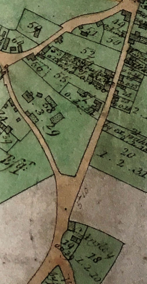
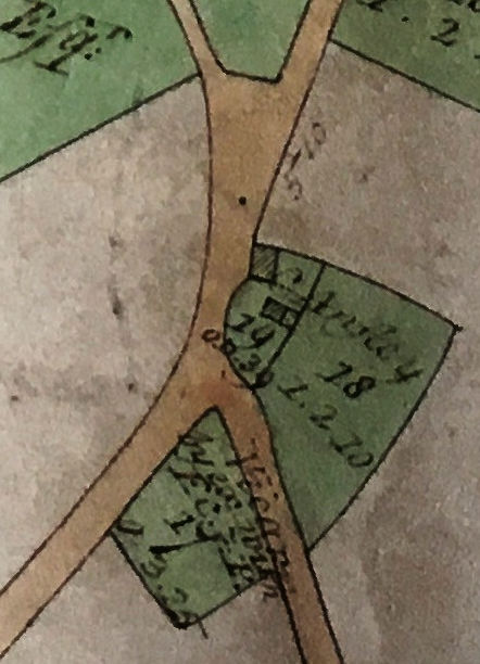
Inclosure Award: Extract from the map included within the Inclosure Award showing Trumpington village, 1804, published as part of the Inclosure Award in 1809. Cambridgeshire Archives. Reference KCB/8/4/1. See pages about Farming and Inclosure and the Inclosure Award.