| Trumpington Local History Group Trumpington Timeline: 1 - 1000 AD |
| Copyright © Trumpington Local History Group, 2013. Updated 11 March 2013. Email: admin@trumpingtonlocalhistorygroup.org |
Edited by Andrew Roberts
1000 years in Trumpington's history: Late Iron Age, Romano-British and
Anglo-Saxon settlement and the naming of the village. One of a series of
pages with Trumpington's timeline.
1000 years in Trumpington's history: Late Iron Age, Romano-British and
Anglo-Saxon settlement and the naming of the village. One of a series of
pages with Trumpington's timeline.
30-70 AD
A bronze jug and bowl (patera) were discovered in the north
of Trumpington in 1709 and are now on display in the
Fitzwilliam Museum.
The patera has a central medallion of an eagle bringing down
a deer, then a frieze and decoration, with a separate handle
with a ram's head decoration. They have been identified in
recent years as being among a group of items found in 1709;
other items included pots, an amphora and the remains of a
rectangular folding gaming board. The items date from c. 30-
70 AD, the pots with known potter's marks. They were
described in the 1722 and 1806 editions of Camden's
Britannia as being found by labourers working at Dam Hill,
to the west of Trumpington Road (said to be on the right side
of the road coming out of Cambridge, about ¼ mile from the
milestone not far from the river). They are typical of items
found in Iron Age burials on the edge of the Roman Empire
at the time of the Roman conquest of Britain. These were
elite and conspicuous burials of the Romanised or soon-to-be
Romanised elite, in areas separate from the main cemeteries.
There are comparable burials at Bartlow Hills and
Wheathampstead. The finds appear to have been given to
Trinity College by a son of James Thompson (Anstey Hall),
owner of the land.
Sources of information: Dr Lucilla Burn, Camden's Britannia
and Roman Finds from Trumpington, Fitzwilliam Museum, 3
November 2010. Finds in the Greek & Roman Gallery, case
12 [seen 3 November 2010], Loan Ant. 36, 37, 38 (lent by
Trinity College). Babington, Charles Cardale (1883). Ancient
Cambridgeshire, or an Attempt to Trace Roman and Other
Ancient Roads That Passed Through the County of
Cambridge. : George Bell & Sons. Page 48. Fox, Cyril
(1923). The Archaeology of the Cambridge Region.
Cambridge: Cambridge University Press. Page 205.
1st-5th centuries, Romano-British
Roman invasion in 43 AD and advance across England
from the south east. A substantial part of the country
was formally surrendered to Rome in the late summer of
43 AD in a ceremony at Camulodumum (Colchester).
The south Cambridgeshire area had probably been under
Catuvellauni control up to this time.
There was an early Roman military base at Great
Chesterford and a wooden then walled settlement at
Cambridge. This was to the north of the river, the basis
for a small town rather than a major military centre.
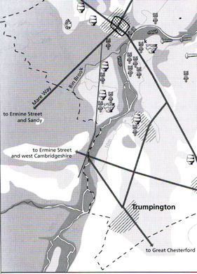
There was a network of Roman roads in the
Trumpington area. One road, later called Via Devana,
ran along the eastern side of the area (from Cambridge to
Red Cross to the east of the current Hills Road, between
the 'fens' of Trumpington/Shelford and Cherry Hinton):
this was part of a major route from Colchester through
Cambridge to Godmanchester where it linked with
Ermine Street. A second road ran east-west from Red
Cross to Grantchester. Writing in 1808, Lysons and
Lysons describe this as crossing the great London road
just to the north of the village of Trumpington
(Babington repeats this in 1888). In 2008, Christopher
Evans plotted the road line further north, running from
the Addenbrooke's Hospital area towards Dam Hill,
crossing the current north-south road a short distance
north of the Long Road/Trumpington Road junction and
possibly continuing to a ford between Grantchester and
Newnham. A third road may have run south-north from
Great Chesterford/Stump Cross to Cambridge, this may
be pre-Roman. The southwest-north route from Ermine
Street (Royston) to Trumpington and Cambridge may
also be pre-Roman. As in the prehistoric period, the line
of these routes through the village towards Cambridge
was probably to the west of the current main road, along
the slight ridge from the area of Trumpington Hall to
Vicar's Brook and the Leys School.
There were Romano-British settlement sites in the
Trumpington area, including along the east side of the
river to the south west of the current village; pockets of
settlement further to the east including in the Clay Farm
area; a Roman villa near Nine Wells; and the continued
use of the cemetery at Dam Hill in the north of the
parish. In his thesis on the Cambridge region published in
1923, Cyril Fox refers to finds of pottery (terra sigillata)
from Chaucer Road, including fine platters by named
potters found at Upwater Lodge (23 Chaucer Road), part
of the important Dam Hill cemetery area (see above).
Many of the finds from the sites discovered in the 18th
and 19th centuries are held in the Museum of
Archaeology & Anthropology and the Fitzwilliam
Museum. The Clay Farm excavation in 2010 identified
pits, a pottery kiln and a possible funerary monument.
The Hutchison site excavation in 2002-03 established
substantive evidence of Late Iron Age/Early Roman use
of that area, with mixed farming and pottery kilns.
Sources of information: Archaeology reports and visits to
archaeological sites. Babington, Charles Cardale (1883).
Ancient Cambridgeshire, or an Attempt to Trace Roman
and Other Ancient Roads That Passed Through the
County of Cambridge. : George Bell & Sons. Pages 29
and 43-51. Evans, Christopher, with Duncan Mackay
and Leo Webley (2008). Borderlands. The Archaeology
of the Addenbrooke's Environs, South Cambridge.
Cambridge: Cambridge Archaeological Unit. Including
page 19, Roman roads; pages 123-39, summary of
Hutchison site; page 132, map of Roman roads; pages
141 and 151, maps of archaeological sites and
cropmarks. Fox, Cyril (1923). The Archaeology of the
Cambridge Region. Cambridge: Cambridge University
Press. Pages 150-52, 167-221. Kirby, Tony and
Oosthuizen, Susan (eds.) (2000). An Atlas of
Cambridgeshire and Huntingdonshire History.
Cambridge: Anglia Polytechnic University. Map 14.
Lysons, Daniel and Lysons, Samuel (1808). Magna
Britannia. Cambridgeshire. Republished 1978.
Wakefield: EP Publishing. Pages 44-45. Taylor, Alison
(1999). Cambridge: the Hidden History. Map on page
24; pages 25-38, 41. The Victoria History of the
Counties of England (1948). The History of the County
of Cambridge & the Isle of Ely. Volume II. Page 48.
The Victoria History of the Counties of England
(1978).The History of the County of Cambridge & the
Isle of Ely. Volume VII: Roman Cambridgeshire. Pages
1-3, 16-21, 28, 46.
Local History Group web page: Clay Farm Archaeology,
August 2010.
Roman invasion in 43 AD and advance across England
from the south east. A substantial part of the country
was formally surrendered to Rome in the late summer of
43 AD in a ceremony at Camulodumum (Colchester).
The south Cambridgeshire area had probably been under
Catuvellauni control up to this time.
There was an early Roman military base at Great
Chesterford and a wooden then walled settlement at
Cambridge. This was to the north of the river, the basis
for a small town rather than a major military centre.
There was a network of Roman roads in the
Trumpington area. One road, later called Via Devana,
ran along the eastern side of the area (from Cambridge to
Red Cross to the east of the current Hills Road, between
the 'fens' of Trumpington/Shelford and Cherry Hinton):
this was part of a major route from Colchester through
Cambridge to Godmanchester where it linked with
Ermine Street. A second road ran east-west from Red
Cross to Grantchester. Writing in 1808, Lysons and
Lysons describe this as crossing the great London road
just to the north of the village of Trumpington
(Babington repeats this in 1888). In 2008, Christopher
Evans plotted the road line further north, running from
the Addenbrooke's Hospital area towards Dam Hill,
crossing the current north-south road a short distance
north of the Long Road/Trumpington Road junction and
possibly continuing to a ford between Grantchester and
Newnham. A third road may have run south-north from
Great Chesterford/Stump Cross to Cambridge, this may
be pre-Roman. The southwest-north route from Ermine
Street (Royston) to Trumpington and Cambridge may
also be pre-Roman. As in the prehistoric period, the line
of these routes through the village towards Cambridge
was probably to the west of the current main road, along
the slight ridge from the area of Trumpington Hall to
Vicar's Brook and the Leys School.
There were Romano-British settlement sites in the
Trumpington area, including along the east side of the
river to the south west of the current village; pockets of
settlement further to the east including in the Clay Farm
area; a Roman villa near Nine Wells; and the continued
use of the cemetery at Dam Hill in the north of the
parish. In his thesis on the Cambridge region published in
1923, Cyril Fox refers to finds of pottery (terra sigillata)
from Chaucer Road, including fine platters by named
potters found at Upwater Lodge (23 Chaucer Road), part
of the important Dam Hill cemetery area (see above).
Many of the finds from the sites discovered in the 18th
and 19th centuries are held in the Museum of
Archaeology & Anthropology and the Fitzwilliam
Museum. The Clay Farm excavation in 2010 identified
pits, a pottery kiln and a possible funerary monument.
The Hutchison site excavation in 2002-03 established
substantive evidence of Late Iron Age/Early Roman use
of that area, with mixed farming and pottery kilns.
Sources of information: Archaeology reports and visits to
archaeological sites. Babington, Charles Cardale (1883).
Ancient Cambridgeshire, or an Attempt to Trace Roman
and Other Ancient Roads That Passed Through the
County of Cambridge. : George Bell & Sons. Pages 29
and 43-51. Evans, Christopher, with Duncan Mackay
and Leo Webley (2008). Borderlands. The Archaeology
of the Addenbrooke's Environs, South Cambridge.
Cambridge: Cambridge Archaeological Unit. Including
page 19, Roman roads; pages 123-39, summary of
Hutchison site; page 132, map of Roman roads; pages
141 and 151, maps of archaeological sites and
cropmarks. Fox, Cyril (1923). The Archaeology of the
Cambridge Region. Cambridge: Cambridge University
Press. Pages 150-52, 167-221. Kirby, Tony and
Oosthuizen, Susan (eds.) (2000). An Atlas of
Cambridgeshire and Huntingdonshire History.
Cambridge: Anglia Polytechnic University. Map 14.
Lysons, Daniel and Lysons, Samuel (1808). Magna
Britannia. Cambridgeshire. Republished 1978.
Wakefield: EP Publishing. Pages 44-45. Taylor, Alison
(1999). Cambridge: the Hidden History. Map on page
24; pages 25-38, 41. The Victoria History of the
Counties of England (1948). The History of the County
of Cambridge & the Isle of Ely. Volume II. Page 48.
The Victoria History of the Counties of England
(1978).The History of the County of Cambridge & the
Isle of Ely. Volume VII: Roman Cambridgeshire. Pages
1-3, 16-21, 28, 46.
Local History Group web page: Clay Farm Archaeology,
August 2010.
| Extract from map of Prehistoric, Roman and early Anglo-Saxon sites. In Taylor, Alison (1999). Cambridge: the Hidden History, p. 24. |
Early 5th century
Withdrawal of the Roman legions from Britain: Rome
was attacked by the Goths in 410AD and Emperor
Honorius may have indicated that Britons should
organise their own defences.
Sources of information: Dr Sam Newton, Cambridge
and the Kingdom of East Anglia, Institute of Continuing
Education, University of Cambridge, November 2009.
1600th Anniversary of the End of Roman Britain Web
site [accessed 14 December 2010].
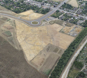
| Aerial view of the archaeological investigations on Clay Farm, to the east of Shelford Road, with the new Addenbrooke's Road and work on the Guided Busway in the old railway cutting, July-August 2010. Source: Oxford Archaeology East. |

| Truncated remains of a small early Roman period pottery kiln on the Clay Farm site. Photo: Stephen Brown, 11 August 2010. |
673-730
Æthelthryth [St Aethelburg or St Etheldreda] founded a monastery at Ely in 673. She died at
Ely in 679, leaving instruction that she be buried in a wooden coffin. Sixteen years after
Æthelthryth's death, brothers from the monastery travelled from Ely to Cambridge to obtain a
stone coffin (a marble sarcophagus) from the ruins of the Roman town. In The Ecclesiastical
History, c. 730, the Venerable Bede describes her way of life and refers to Cambridge as the
little ruined walled Roman city of Grantacaestir.
Sources of information: Dr Sam Newton, Cambridge and the Kingdom of East Anglia,
Institute of Continuing Education, University of Cambridge, November 2009. Campbell, J.
(2008). Bede (673/4-735)', Oxford Dictionary of National Biography, Oxford University Press.
[accessed 14 December 2010.]Thacker, Alan (2009). 'Æthelthryth (d. 679)', Oxford Dictionary
of National Biography, Oxford University Press. [accessed 14 December 2010] The Victoria
History of the Counties of England (1959). The History of the County of Cambridge & the Isle
of Ely. Volume III. The City and University of Cambridge. City of Cambridge, page 2.
| Logo of the 1600th Anniversary of the End of Roman Britain Web site. |
5th-8th centuries
Angles and Saxons from northern Germany took
land from the native British people in southeast
England and an Anglo-Saxon culture developed
alongside the Romano-British culture, with the
growth of small kingdoms. The Old English language
was close to Germanic roots.
East Anglia was settled by the Angles, with the
development of scattered rural communities. The
River Cam was a frontier between East Anglia and
Mercia. Cambridge continued as an Anglo-Saxon
settlement and port, with the River Cam providing a
major route into Britain.
The important Iron Age/Roman cemetery at Dam
Hill continued in use (the area between Latham
Road, River Farm, and Chaucer Road). In the
Anglo-Saxon period, Cyril Fox refers to this as an
inhumation cemetery, with finds including a
spearhead, clasps and brooches (see figures).
Sources of information: Evolving English: One
Language, Many Voices, exhibition at the British
Library, 2010-11. Medieval London gallery,
Museum of London. Fox, Cyril (1923). The
Archaeology of the Cambridge Region. Cambridge:
Cambridge University Press. Pages 227, 249.
Oosthuizen, Susan (1996). Cambridgeshire from the
Air. Stroud: Alan Sutton Publishing. Page 25.
Taylor, Alison (1999). Cambridge: the Hidden
History. Pages 39-50. The Victoria History of the
Counties of England (1938). The History of the
County of Cambridge & the Isle of Ely, Volume I.
Page 316-17. The Victoria History of the Counties of
England (1982). A History of Cambridgeshire and
the Isle of Ely, Volume VIII. Armingford and
Thriplow Hundreds. Trumpington, page 248.
991
Ealdorman Beorhtnoth [Brihtnoth or Byrhtnoth] died a hero during the Battle of Maldon
(Essex), leading the Anglo-Saxon fight against the Vikings. He owned extensive land in
Cambridgeshire and other counties. In his will, he left the monks of Ely nine estates, including a
manor at Trumpington. The bequest was completed on the death of his wife, Aelfflaed, who
died c. 1006. Ely was accumulating a great deal of property, particularly by purchase between
970 and 1020, following the refoundation of the monastery.
Sources of information: Abels, Richard (2004). 'Byrhtnoth (d. 991)', Oxford Dictionary of
National Biography, Oxford University Press. [accessed 14 December 2010.] Liber Eliensis.
A History of the Isle of Ely from the Seventh Century to the Twelfth, Compiled by a Monk of
Ely the Twelfth Century. Translated by Janet Fairweather (2005). Woodbridge: Boydell Press.
Pages 160-63. Miller, Edward (1951). The Abbey and Bishopric of Ely. Cambridge: CUP.
Pages 16-23. Taylor, Alison (1999). Cambridge: the Hidden History. Pages 129. The Victoria
History of the Counties of England (1982). A History of Cambridgeshire and the Isle of Ely,
Volume VIII. Armingford and Thriplow Hundreds. Trumpington, page 251.
c. 890-905
King Alfred (c. 849 - c. 899) ordered the writing of the Anglo-Saxon Chronicle. Written in Old
English, copies were distributed across the country and updated locally. Nine copies survive,
including one in the Parker Library, Corpus Christi College, Cambridge.
Sources of information: Evolving English: One Language, Many Voices, exhibition at the
British Library, 2010-11. Anglo-Saxon Chronicle (Wikipedia) [accessed 14 December 2010].
Wormald, Patrick (2006). 'Alfred (848/9-899)', Oxford Dictionary of National Biography,
Oxford University Press. [accessed 14 December 2010].
8th-9th century
Vikings from Norway and Denmark raided England from the late 700s. The Great Army of
Danish Vikings landed in England in 865 and defeated most of the English kingdoms over the
next few years, including East Anglia in 869-70. In 878, the West Saxon King Alfred [Ælfred]
rallied his troops against the Vikings. By 886, he had captured the London area and made peace
with the Danish King Guthrum but the Danes retained control of the north and east of England
(the Danelaw).
In East Anglia, a Danish army led by King Guthrum established Eastern Danelaw, in 880-81
according to the Anglo-Saxon Chronicle. The Cambridgeshire area was a conflict zone between
Mercia and East Anglia. The Danes reorganised the southern part of the county, including
establishing a fortified enclosure and mint in Shelford. Cambridge developed as a defensive and
commercial centre, called Grante-brycge in the Chronicle. The Danes in this area were defeated
by Edward the Elder in 917, but were not forced to give up their land, so there was continuity.
There was a probable change in land use from dispersed farmsteads to the communal
cultivation of large open fields divided into strips, requiring greater co-operation between the
owners of the strips. The previous settlement pattern had been scattered hamlets and
farmsteads and this farming change may have lead to the development of villages.
Sources of information: Dr Sam Newton, Cambridge and the Kingdom of East Anglia,
Institute of Continuing Education, University of Cambridge, November 2009. Medieval London
gallery, Museum of London. Costambeys, Marios (2008). 'Guthrum (d. 890)', Oxford
Dictionary of National Biography, Oxford University Press [accessed 14 December 2010].
Kirby, Tony and Oosthuizen, Susan (eds.) (2000). An Atlas of Cambridgeshire and
Huntingdonshire History. Cambridge: Anglia Polytechnic University. Map 26, 30. Oosthuizen,
Susan (1996). Cambridgeshire from the Air. Stroud: Alan Sutton Publishing. Page 25. The
Victoria History of the Counties of England (1959). The History of the County of Cambridge &
the Isle of Ely. Volume III. The City and University of Cambridge. City of Cambridge, page 2-
3. Wormald, Patrick (2006). 'Alfred (848/9-899)', Oxford Dictionary of National Biography,
Oxford University Press. [accessed 14 December 2010].
10th century
The County and Hundred boundaries within
Cambridgeshire became established in the early
10th century.
The nucleated village of 'Trumpington' and the use
of that name also become established in the 10th
century.
Most place names in Cambridgeshire are
Anglo-Saxon in origin. Names ending in 'ton' tend
to have formed later than those ending in 'ham'.
The 'ton' suffix is more common in the Mercia
area west of the Cam.
Trumpington appears to be one of a number of
parishes to the south of Cambridge with names
formed from a personal name and 'ton'.
Sources of information: Kirby, Tony and
Oosthuizen, Susan (eds.) (2000). An Atlas of
Cambridgeshire and Huntingdonshire History.
Cambridge: Anglia Polytechnic University. Maps
26, 31.
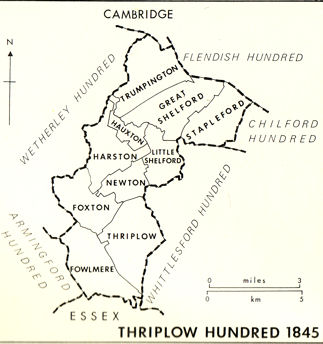
| Map of the Thriplow Hundred. From The Victoria History of the Counties of England (1982). A History of Cambridgeshire and the Isle of Ely, Volume VIII. Armingford and Thriplow Hundreds. Thriplow Hundred, page 153. |
10th century
By the late Anglo-Saxon period, Cambridge was established as the county town and an
important market for the area. It was developing to the south east of the Roman river crossing.
There was a ditch, the 'King's Ditch', around the new settlement, probably intended as a
customs barrier rather than a defensive line. The Ditch was crossed by two routes out of
Cambridge to the south and east, the road to Trumpington and the highway on the line of the
Roman road towards Colchester. The route now called Trumpington Street was the primary
focus for the development of the town, reaching as far as the King's Ditch. A series of churches
were established along this route, including St Botolph's on the town side of the King's Ditch,
dedicated to the patron saint of travellers. By the 13th century, there were tollgates on the two
routes, 'Trumpington Gate' and 'Barnwell Gate'. The King's Ditch limited the development of
Cambridge to the south and east until the open fields were enclosed in the 19th century.
Sources of information: National Monuments Record web site [accessed 22 December 2010].
St Botolph's Church Web site [accessed 23 December 2010]. Taylor, Alison (1999).
Cambridge: the Hidden History. Pages 45-49 and map page 46. The Victoria History of the
Counties of England (1959). The History of the County of Cambridge & the Isle of Ely.
Volume III. The City and University of Cambridge. Medieval Cambridge, page 3 and
Economic History, page 89.
| Timeline pages 1000- 1- 1001- 1501- 1601- 1701- 1801- 1851- 1901- 1951- 2001- 0 BC 1000 AD 1500 1600 1700 1800 1850 1900 1950 2000 present |
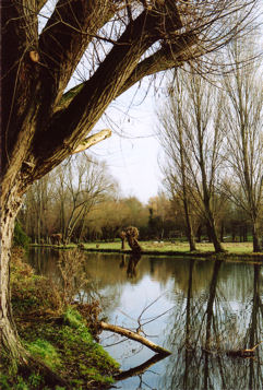
| Looking across the River Cam towards the Dam Hill area (the west end of Chaucer Road and Latham Road). Photo: Andrew Roberts, January 2011. |

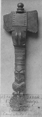
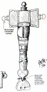
| Small bronze steelyard with weight, Roman, from Dam Hill, Trumpington, Deck Collection, Cambridge Antiquarian Society, 1883 (now in Cambridge University Museum of Archaeology and Anthropology, 83CAS817). From a photograph used by Percy Robinson, 1920s-1940s. |
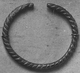
| Bronze rope-twist bracelet, Roman, from Trumpington, Deck Collection, Cambridge Antiquarian Society, 1883 (now in Cambridge University Museum of Archaeology and Anthropology, 83CAS552). From a photograph used by Percy Robinson, 1920s-1940s. |
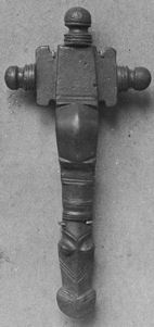
| Bronze fibula, Saxon, from Trumpington, Deck Collection, Cambridge Antiquarian Society, 1883 (now in Cambridge University Museum of Archaeology and Anthropology, number not traced). Left: from a photograph used by Percy Robinson, 1920s-1940s. Right: probably the same object, illustrated by Cyril Fox in Fox, 1923, plate xxx.6, facing page 268. |
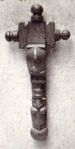
| Cruciform horse headed bronze brooch, Saxon, from Trumpington, Deck Collection, Cambridge Antiquarian Society, 1883 (now in Cambridge University Museum of Archaeology and Anthropology, 83CAS518). Left: from a photograph used by Percy Robinson, 1920s-1940s. Right: illustrated in Fox, 1923, plate xxix.5, facing page 252. |
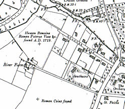
| Sites in the Dam Hill area, Ordnance Survey map 1904. |
Late 7th century
There is evidence of the development of the
Anglo-Saxon settlement in Trumpington, to the
south of the current church. The area was
excavated in 2011 in advance of house
construction on the Trumpington Meadows
site. It included a number of sunken buildings
('grubenhause') and four burial pits. The
national significant finds included a bed burial
with the body of a young girl wearing a gold
cross (announced in March 2012).
Sources of information: University of
Cambridge press release.
Local History Group web pages: Trumpington
Meadows archaeological visit, 24 May 2011.
Discovery of Anglo-Saxon bed burial and cross.
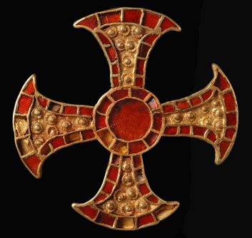
| The Trumpington Cross, after cleaning. © Cambridge Archaeological Unit. |