Tom Phillips (Oxford Archaeology East) gave a talk about the archaeology of Clay Farm, including Hobson Square and the Clay Farm Centre, at the Local History Group meeting on 22 March 2018. There was also a talk by Andy Robinson about public art. This was one of three events held in the Clay Farm Centre before its opening in April 2018. Report by Andrew Roberts, with thanks to Tom Phillips and Oxford Archaeology East.
Speaking in the Clay Farm Centre alongside Hobson Square, Tom said that the archaeologists had excavated on this very spot. He was pleased that their work had helped give a sense of identity to Trumpington.
Archaeologists from Oxford Archaeology East worked on excavations across Clay Farm and at Fawcett Primary School from 2010-15. These excavations have shown that people have lived here for over 3000 years, from the Middle Bronze Age through the Roman period, with six settlements and field systems in the Clay Farm area. There have been further excavations in other parts of Trumpington and across the Southern Fringe, showing the extent of human occupation on the higher land between the River Cam and Hobson’s Brook and to the east of Hobson’s Brook.
Tom said that Clay Farm is his favourite site, as it is rare to find such a range of evidence during one excavation, including Middle Bronze Age settlements and field systems, Iron Age enclosed farmsteads, and Roman enclosed farmsteads and high status cremation burials. There was little evidence of Saxon occupation on Clay Farm, with the focus changing in that period to the area of the historic village, but the team did find modern features including the remains of World War 2 searchlights!
In the Middle Bronze Age (c. 1500-1150 BC) , the landscape had been cleared of trees. The Clay Farm area was divided into strip fields, running down the contours from the higher land to the west (where the current village developed) towards the valley (Hobson’s Brook). These strip fields were then overlain by rectangular fields with bigger ditches. When these ditches were excavated, items were found which came from the settlements, and they also provided environmental information, including berries and insects. Two of the settlements areas had middens with waste material. The excavation to the east of the original Fawcett Primary School buildings revealed a cremation cemetery. In the land at the southern end of the site, there were large ditches, clearly visible in aerial photographs (the area of the Addenbrooke’s Road roundabout, Abode development).
In the limited time available, Tom concentrated on a few of the excavated areas.
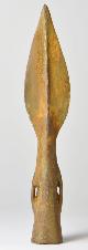
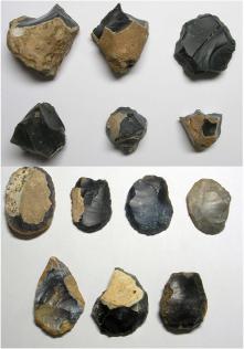
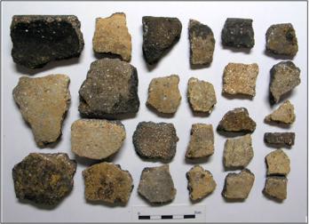
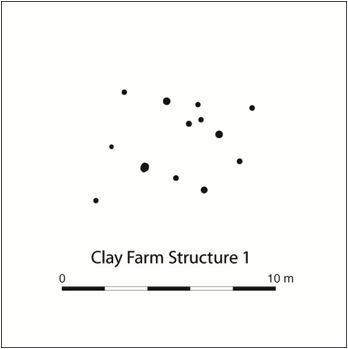
Tom described the settlement area in the northern part of the site (Settlement 1 on the plans) (now covered by the Halo and Aura developments). This included structures on the higher ground to the west (now covered by Clay Farm Drive in the Halo development) and midden waste in a ditch to the east (parallel with the north side of the east-west tree belt, now covered by Green Lane, Halo development). The archaeologists found 4 kg of ceramics in the ditch, which was a substantial amount to be found in a site from that period, including decorated fineware. There were also bone pins and needles, struck flint arrowheads and scrapers. Metalwork preserved in the ditch included a Middle Bronze Age copper alloy socketed spearhead and a ‘moustached type’ item which may have been a scabbard chape. The structures were identified through the survival of post holes. The burials included a female, and had been radio-carbon dated to the range 1515-1260 BC.
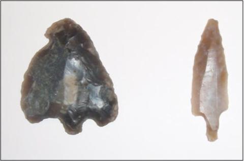
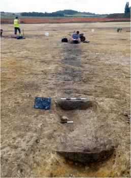
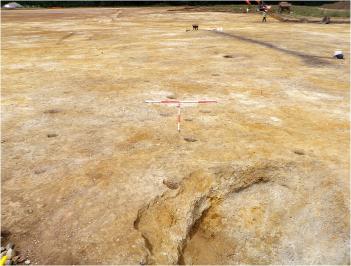
The excavation to the rear of Fawcett Primary School (on the site of the school extension) identified a Bronze Age barrow and cremation cemetery. The barrow may be Early Bronze Age. The centre of the barrow was outside the excavated area, but there were 37 cremation and 1 inhumation burials in the ditch that was excavated, 7 of which have been dated to the range 1530-1260 BC. There was also a small Early Iron Age ring-ditch, dated to the range 780-520 BC.


There was also evidence of a routeway or trackway across the area. The excavation uncovered two ditches close together, which must have continued to the west and also to the wetter area to the east where they were identified in the Clay Farm excavation. The ditches were larger in the Fawcett site than on Clay Farm, with burials close to or associated with the alignment. Tom said that this may have been an important route, along the same alignment as the possible Roman road from Grantchester to Red Cross, proposed by early writers including F.G. Walker (1911) and Cyril Fox (1923).
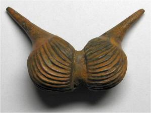
There was another settlement area to the south (Settlement 2 on the plans) (now the Abode and Paragon developments). The finds from this included pottery, bone points, metalwork and Bronze Age structures than informed the planning for the ‘Bronze House’ artwork in Hobson Square. (Tom’s talk was immediately followed by one by Andy Robinson, about the public art features.)

Tom added that further work was undertaken in the summer of 2015 (in the area where Trumpington Park Primary School has been built). This found more ditches, a wooden bowl in the bottom of a Bronze Age well and a weaving comb.
Tom then concentrated on the Iron Age evidence. He said that in the Early Iron Age, a settlement was established in the northern part of the Clay Farm area, within the Bronze Age field system. This revealed a large assemblage of pottery in pits which had been dated to 800-350 BC. In the Middle Iron Age, there was a series of enclosed farmsteads, 300-100 BC, in the western part of the site, extending into the Cambridge Professional Development Centre (CPDC)/Fawcett Primary School playing field.

There was continuous occupation into the Roman period, with two main areas of activity. Close to the footpath from Paget Close to the Busway and Addenbrooke’s Hospital, there were two high status cremation burials within a rectangular enclosure (in the area now built up as Hawkey Road in the Aura development, north of the Clay Farm Centre). These Early Roman cremations, c. 43 AD, were in a large circular pit, with 11 ceramic vessels. These were high status imported finewares, including Samian wares and others from Gaul which could be dated to 10-30 AD. There was also a fine toiletry set. The cremated remains were placed in a wooden box covered in leather, with a complex lock plate and hinges. There was also an Early Roman pottery kiln. These would have been highly self-sufficient communities with accumulated wealth.


Tom Phillips finished his talk by stressing that here in the Clay Farm Centre we were on the spot where there had been one of the earliest Bronze Age strip fields, then in the Roman period the land had been heavily used as a farmstead.

Questions
Q: how far did the settlement area extend?
A: Tom said that the local topography was the key. In the Middle Bronze Age, there were two large blocks of settlement in the Clay Farm area, similar to the Cambridge Biomedical Campus ridge where there were three settlements (AstraZeneca and Papworth excavation). There were also settlements on the Trumpington Meadows and Trumpington Park & Ride areas, plus a prehistoric monument and 100s of Iron Age pits and the later Saxon village. There was good free draining soil on these ridges and water sources, ideal conditions for settlement. Tom suggested looking in our back gardens!
Q: if there were 37 cremation burials (in the Bronze Age cemetery at Fawcett School), what would have been the population?
A: there is always a tendency to underestimate numbers. In this case, there may have been more burials around the rest of the barrow and there may have been many people who died but were not buried there over the period of 300 years. In that time, there may have been an extended family group of perhaps 20-30 people in each of 2 or 3 farmsteads.
Q: were the Bronze Age ditches used for irrigation?
A: the use would have changed over time, including processing animals, drainage and showing off the abilities of the community. Ditches were more functional in the Roman period and may have included cultivation beds.
Q: would there have been hedges beside the ditches to keep stock in?
A: the evidence has been truncated but it is assumed there may have been a bank with a hedge.
Tom Phillips at the meeting on 22 March 2018. Photo: Andrew Roberts.
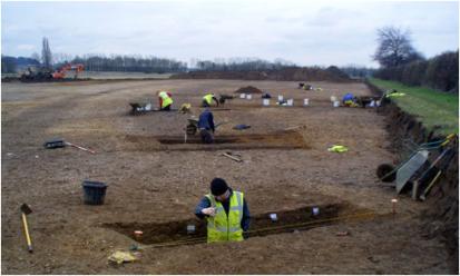
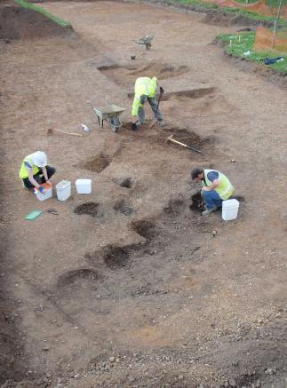
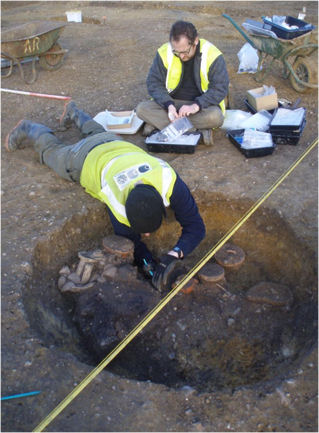
Excavating the Clay Farm field to the east of Fawcett Primary School. Oxford Archaeology East, early 2011.

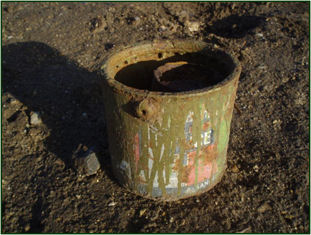
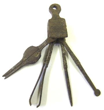
Paint tin with a baked-bean tin inside, found on the site of the World War 2 searchlight. Oxford Archaeology East, 2011.


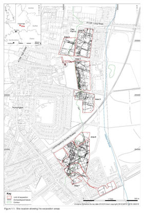
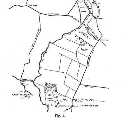
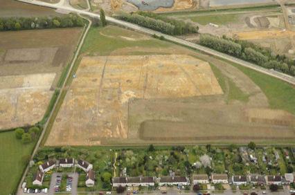
Site locations on Clay Farm, showing the excavated areas. Oxford Archaeology East.
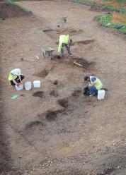
Excavating the Clay Farm field to the east of Fawcett Primary School (now Woodpecker Way, Aura development). Oxford Archaeology East, early 2011.

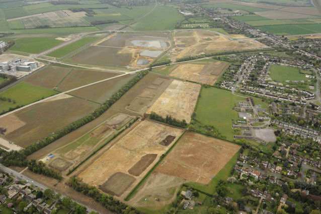
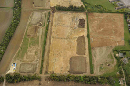
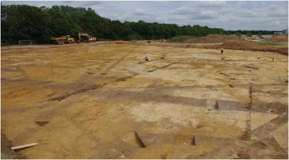
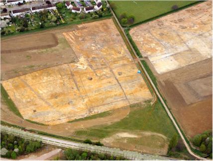
Aerial view of the northern area of the Clay Farm archaeological excavation, with evidence of the Middle Bronze Age field system (OAE Areas A and B, Settlement 1). The view is from the north, from over Long Road, with Clay Farm House lower right, Fawcett Primary School upper right and Hobson’s Brook hidden in the tree belt to the left. There were extensive finds in the area parallel with the tree belt upper centre, still to be excavated at this point. The Aura and Halo developments now cover this area, with Lime Avenue constructed to the right of the north-south hedgerow. Oxford Archaeology East, 13 April 2011.

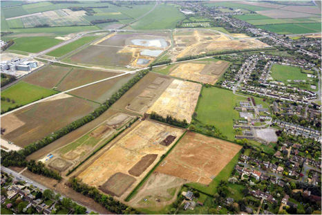
Aerial view of the archaeological excavation on Clay Farm, looking east from Shelford Road. The old railway line and cutting is to the left (being converted into the Busway), with the newly built Addenbrooke’s Road and roundabout to the right. Evidence of Middle Bronze Age ditches can be seen in the areas cleared of topsoil. The Abode development has now been built on these cleared areas, with the Paragon development built on land to the upper right. Oxford Archaeology East, July-August 2010.


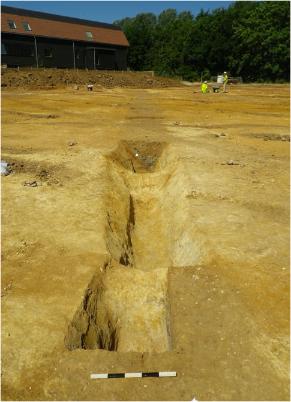
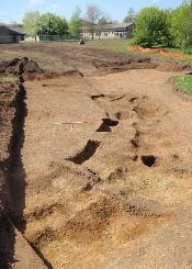
Excavating the ditch in the northern part of Clay Farm, Settlement 1. The tree belt is to the right. This land is now covered by Green Lane, Halo development, with Lime Avenue going left to right in the area beyond the cleared topsoil and Trumpington Community College in the area upper right in sunlight. Oxford Archaeology East, February 2011.
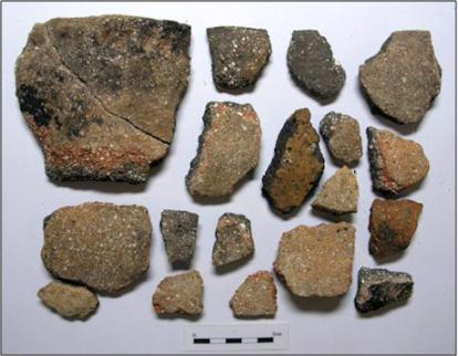
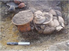
Deverel-Rimbury ceramics excavated from the Middle Bronze Age ditch. Oxford Archaeology East, 2011.


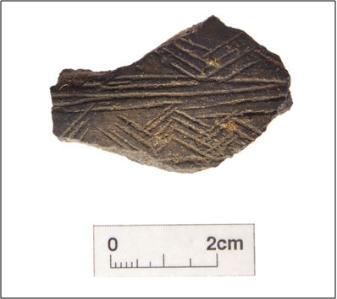
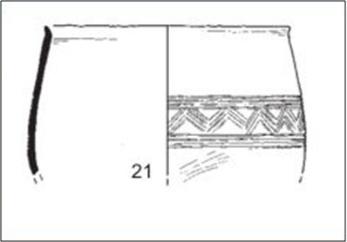
Decorated fineware pottery from the Middle Bronze Age ditch, with drawing showing the style of the full pot. Oxford Archaeology East, 2011.


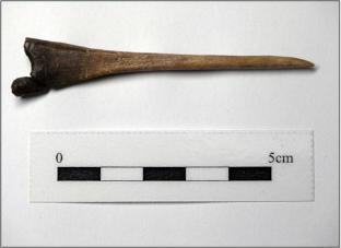
Bone needle from the Middle Bronze Age ditch. Oxford Archaeology East, 2011.
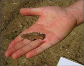
Small bronze spearhead from the Middle Bronze Age ditch. Oxford Archaeology East, December 2010.
Middle Bronze Age bronze scabbard chape? Oxford Archaeology East, 2011.


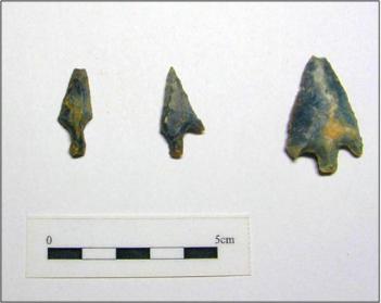
Middle Bronze Age struck flint arrowheads and scrapers from the northern part of Clay Farm, Area B. Oxford Archaeology East.

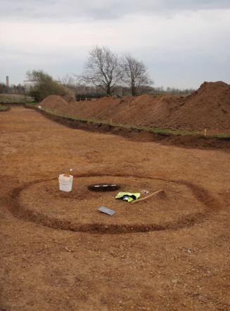
The Bronze Age barrow and cremation cemetery, Fawcett School site. Oxford Archaeology East, spring 2014.
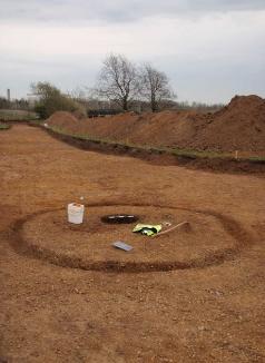

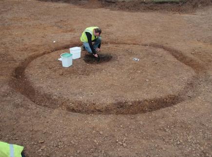
The Bronze Age ring-ditch, Fawcett School site. Oxford Archaeology East, spring 2014.


Map by F.G. Walker (1911) showing the possible route of a Roman road. ‘Excavations near Latham Road, Trumpington’, Proceedings of the Cambridge Antiquarian Society , 15, p. 192-96.
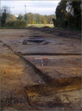
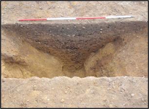
Section through the routeway, Fawcett School excavation. Oxford Archaeology East, spring 2014.

Working on the excavation of the southern part of Clay Farm, Settlement 2, looking south east across the farmland towards Nine Wells and White Hill. Oxford Archaeology East, summer 2010.


Deverel-Rimbury ceramics, polished bone point, metalwork and arrowheads, excavated from Settlement 2. Oxford Archaeology East, summer 2010.


Excavating post holes on Clay Farm, Settlement 2, a pattern which influenced the design of the ‘Bronze House’ artwork in Hobson Square. Oxford Archaeology East, summer 2010.


Excavating the site of Trumpington Park Primary School. Oxford Archaeology East, summer 2015.

Aerial view with evidence of a Middle Iron Age enclosed farmstead, east of the Cambridge Professional Development Centre. Oxford Archaeology East, Clay Farm, early 2011.

Aerial view with evidence of a Romano-British farmstead and rectangular enclosure, north of the path from Paget Close to the Busway, now covered by the Aura development. Oxford Archaeology East, February 2011.


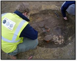
Excavating the Romano-British (Conquest period) cremation burial, north of the path from Paget Close to the Busway, now covered by the Aura development. Oxford Archaeology East, February 2011.

Samian cremation bowl dated to 10-30 AD from the cremation pit. Oxford Archaeology East, February 2011.
Toiletry set dated to 30-50 AD from the cremation pit. Oxford Archaeology East, February 2011.

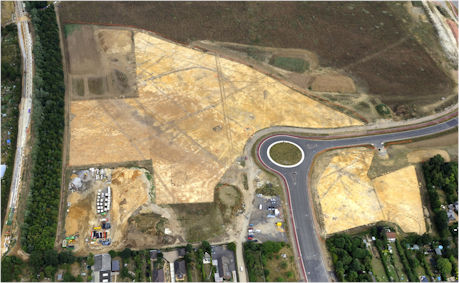
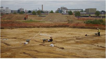
Aerial view of the archaeological excavation on Clay Farm looking east from Foster Road, to the Guided Busway with excavations of Romano-British farmsteads underway in the field to the east of Foster Road. This area is now crossed by Lime Avenue and Hobson Avenue, with the Clay Farm Centre and Hobson Square built in the centre of the view, surrounded by the Aura, Virido and Cala housing developments. Oxford Archaeology East, 13 April 2011.
Aerial view looking west over Clay Farm towards Foster Road, with the Guided Busway in the lower part of the view and the footpath from Paget Close to the Busway and Addenbrooke’s Hospital to the right. The early stage of constructing Hobson Avenue can be seen lower left. The Clay Farm Centre and Hobson Square have been built in the centre of the view. Oxford Archaeology East, early 2011.
Previous site visits and talks by Oxford Archaeology East
Clay Farm site visit, August 2010 ;
Clay Farm site visit, April 2011 ;
Archaeology of Clay Farm, Richard Mortimer, March 2012 ;
Papworth Hospital/Bell School site visit, August 2014 ;
Archaeology of Trumpington and South Cambridge, Tom Phillips, March 2015 .